File:Ordnance Survey Drawings - Bishop's Castle, Shropshire (OSD 200).jpg
Jump to navigation
Jump to search

Size of this preview: 800 × 505 pixels. Other resolutions: 320 × 202 pixels | 640 × 404 pixels | 1,024 × 646 pixels | 1,280 × 808 pixels | 2,560 × 1,615 pixels | 4,000 × 2,524 pixels.
Original file (4,000 × 2,524 pixels, file size: 4.96 MB, MIME type: image/jpeg)
Captions
Captions
Add a one-line explanation of what this file represents
| Bishop's Castle (OSD 200)
|
|||||
|---|---|---|---|---|---|
| Artist |
Budgen, Thomas - Draughtsman |
.jpg) | |||
| Title |
Ordnance Survey Drawings: Bishop's Castle, Shropshire (OSD 200) |
||||
| Object type |
manuscript map |
||||
| Description |
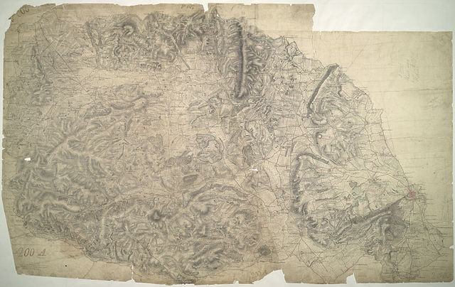
 Centre of map shown on a map of England
English: The River Clun Valley dominates the right-hand section of this plan of Shropshire. To the left is Clun Forest, famous for the sheep of the same name. The plan shows a section of the Offa's Dike running from top left towards bottom right. Extending 176 miles along the English border from the northern Welsh coast south to Chepstow,this great earth bank is eight miles longer than Hadrian's Wall. Unlike Hadrian's Wall, it was never garrisoned..
This image has been georeferenced.
|
||||
| Language |
English |
||||
| Date | 1816 | ||||
| Medium | Pen and ink on paper | ||||
| Dimensions | height: 340 mm (13.38 in); width: 540 mm (21.25 in) | ||||
| Collection | |||||
| Accession number |
Maps OSD 200 |
||||
| Credit line | British Library | ||||
| Notes |
Scale 2 inches : 1 mile (1:31680). Please note that the British Library provides these digital files "as-is"; materials will not be rephotographed under this programme. If resupply of files is required, the requestor will be required to purchase them at the standard rate. |
||||
| References |
http://www.bl.uk/onlinegallery/onlineex/ordsurvdraw/b/002osd000000022u00158000.html (English) |
||||
| Source/Photographer |
|
||||
| Permission (Reusing this file) |
|
||||


_(St_Edwards_Crown).svg)
.jpg¶ms=52.450416_N_-2.937132_E_)
.jpg¶ms=52.285096_N_-3.286458_E_)
.jpg¶ms=52.615736_N_-2.587807_E_)
.jpg¶ms=52.615736_N_-3.177248_E_)
.jpg¶ms=52.387923_N_-3.286458_E_)
.jpg¶ms=52.285096_N_-2.697016_E_)
.jpg¶ms=52.512909_N_-2.587807_E_)
File history
Click on a date/time to view the file as it appeared at that time.
| Date/Time | Thumbnail | Dimensions | User | Comment | |
|---|---|---|---|---|---|
| current | 09:12, 26 September 2013 | | 4,000 × 2,524 (4.96 MB) | LibraryBot (talk | contribs) | {{subst:User:Andrew Gray/OSD|ID= 002OSD000000022U00158000 |OSD_NUM= OSD 200 |MEDIUM= Pen and ink on paper |TITLE= Bishop's Castle, Shropshire |CREATOR= Budgen, Thomas - Draughtsman |YEAR= 1816 |DESCRIPTION= The River Clun Valley dominates the right-han... |
You cannot overwrite this file.
File usage on Commons
The following page uses this file:
File usage on other wikis
The following other wikis use this file:
- Usage on www.wikidata.org
.jpg&oldid=688969027)