File:Plan de Saint-Victor vers 1550, d'après la reprise de Dheulland en 1756 - aviary.jpg
(Redirected from File:Old map of Paris.jpg)

Size of this preview: 725 × 599 pixels. Other resolutions: 290 × 240 pixels | 581 × 480 pixels | 929 × 768 pixels | 1,239 × 1,024 pixels | 2,478 × 2,048 pixels | 4,499 × 3,719 pixels.
Original file (4,499 × 3,719 pixels, file size: 6 MB, MIME type: image/jpeg)
Captions
Captions
Add a one-line explanation of what this file represents
Summary[edit]
| Description |
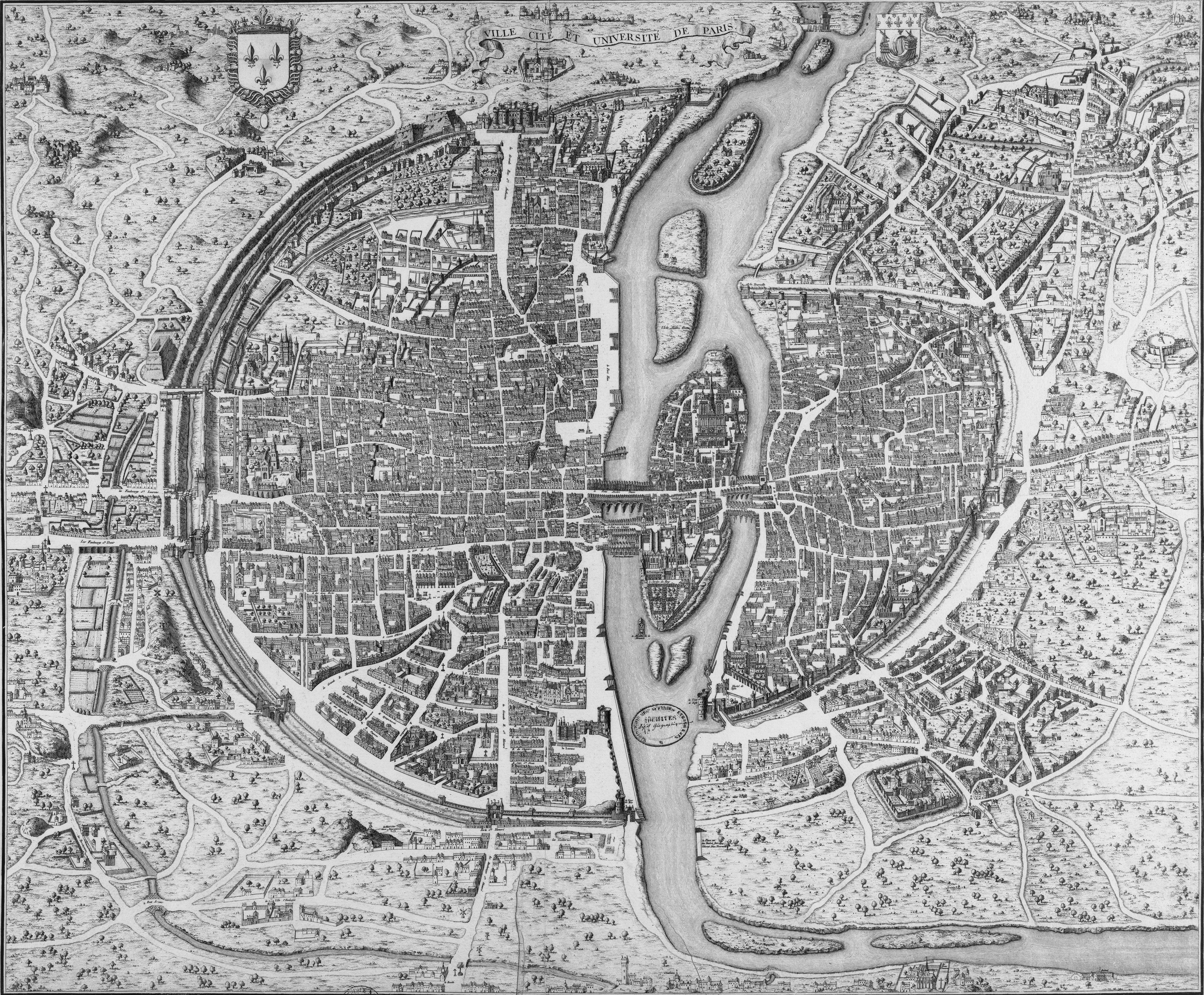
Français : Plan de Saint-Victor vers 1550, d'après la reprise de Dheulland en 1756. Plus ancienne version fidèle du plan premier.
On peut y voir le cimetière des Sts Innocents, la Bastille, l'Hotel de Nesle, Le Louvre qui n'est pas encore le palais royal (Référence: Plansanciens.html de numericable.fr)
English: According to Boutier 2007, pp. 88–89, 287–289, this engraved copy of the Saint Victor map of Paris was created by Guillaume Dheulland in 1756–1757. The map depicts Paris as it was c. 1552. The original Saint Victor map has been attributed to Jacques I Androuet du Cerceau, although this has been disputed. The map is named Saint Victor because it was preserved in a Parisian library of this name in the 18th century. |
||||||||||||||||||||
| Date |
circa 1552, original map 1756–1757, this copy |
||||||||||||||||||||
| Source |
This file was originally downloaded from aviary.com. Info from Plansanciens.html at numericable.fr Originally digitized by the Bibliothèque nationale de France from a map in the Département des Cartes et plans, CPL GE DD-2987 (809 B) |
||||||||||||||||||||
| Author |
Design and engraving of the original map is attributed to
|
||||||||||||||||||||
| Other versions |
.jpg) BNF : EST, RESERVEFOL-QB-201(7) |
||||||||||||||||||||

Sources[edit]
- Boutier, Jean (2007). Les Plans de Paris des origines (1493) à la fin du VIIIe siècle, (second edition). Paris: Bibliothèque nationale de France. ISBN 9782717723892.
Licensing[edit]
|
This work is in the public domain in its country of origin and other countries and areas where the copyright term is the author's life plus 100 years or fewer. | |
| This file has been identified as being free of known restrictions under copyright law, including all related and neighboring rights. | |
File history
Click on a date/time to view the file as it appeared at that time.
| Date/Time | Thumbnail | Dimensions | User | Comment | |
|---|---|---|---|---|---|
| current | 06:32, 21 January 2012 | | 4,499 × 3,719 (6 MB) | Paris 16 (talk | contribs) | Reverted to version as of 06:16, 17 January 2011 |
| 23:23, 19 January 2012 |  | 4,444 × 3,674 (11.26 MB) | Paris 16 (talk | contribs) | edited | |
| 06:16, 17 January 2011 |  | 4,499 × 3,719 (6 MB) | Paris 16 (talk | contribs) | {{Information |Description=A old map of Paris |Source=[http://www.aviary.com/artists/Tinka/creations/1550_stvictor_1 aviary.com] |Date=Unknow |Author=Unknow |Permission={{PD-Old}} |other_versions= }} Category:Old maps of Paris |
You cannot overwrite this file.
File usage on Commons
The following 4 pages use this file:
.jpg)
File usage on other wikis
The following other wikis use this file:
- Usage on fr.wikipedia.org