Category:Dheulland map of Paris
Jump to navigation
Jump to search
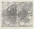
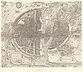
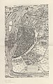
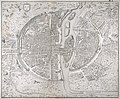
English: The Dheulland map of Paris is a faithrully engraved copy of the Saint Victor map of Paris. It was engraved by Guillaume Dheulland in 1756–1757. The map depicts Paris as it was c. 1552. The original Saint Victor map has been attributed to Jacques I Androuet du Cerceau, although this has been disputed. The map is named Saint Victor because it was preserved in a Parisian library of this name in the 18th century.
Sources
[edit]- Boutier, Jean (2007). Les Plans de Paris des origines (1493) à la fin du VIIIe siècle, (second edition). Paris: Bibliothèque nationale de France. ISBN 9782717723892.
Subcategories
This category has only the following subcategory.
P
Media in category "Dheulland map of Paris"
The following 27 files are in this category, out of 27 total.
-
 Ville, Cite et Universite de Paris.jpg 4,693 × 3,865; 10.53 MB
-
 Atlas des anciens plans de Paris - 048. Paris en 1555 - David Rumsey.jpg 18,137 × 24,932; 96.22 MB
-
 Atlas des anciens plans de Paris - 049. Paris en 1555 - David Rumsey.jpg 18,184 × 24,886; 93.71 MB
-
 Atlas des anciens plans de Paris - 050. Paris en 1555 - David Rumsey.jpg 27,544 × 24,699; 156.54 MB
-
 Atlas des anciens plans de Paris - Paris en 1555 - BHVP.jpg 5,218 × 4,373; 21.53 MB
-
 Atlas des anciens plans de Paris - Paris en 1555 - David Rumsey.jpg 19,300 × 16,850; 135.35 MB
-
 Atlas des anciens plans de Paris - Paris en 1555 A - BHVP.jpg 2,818 × 4,373; 3.78 MB
-
 Atlas des anciens plans de Paris - Paris en 1555 B - BHVP.jpg 2,840 × 4,445; 4.08 MB
-
 Dheulland 1756-7 copy of c1552 St Victor map of Paris - BNF-EST, RESERVEFOL-QB-201(7).jpg 11,610 × 8,581; 18.41 MB
-
 Dheulland 1756-7 copy of ca. 1552 Saint Victor map of Paris - BNF.jpg 9,727 × 7,992; 14.59 MB
-
 Guillaume Dheulland, Plan en perspective de la ville de Paris, 1766 - Gallica.jpg 11,816 × 8,382; 24.83 MB
-

-
 Plan de la ville de Paris au XVIe siècle - Paris Musées.jpg 10,048 × 8,504; 67.26 MB
-
 Plan de Paris au seizième siècle by Ludovic Baschet, 1800 - Gallica.jpg 7,615 × 6,269; 10.14 MB
-

-

-

-
 Plan de Paris au XVIe siècle by Guillaume Dheulland - Gallica.jpg 11,178 × 8,862; 50.2 MB
-

-

-

-
 Plan en Perspective, De La Ville De Paris, telle qu'elle etoit sous le Regne de Charles IX - 02.jpg 11,345 × 8,448; 23.81 MB
-
-
 Plan en Perspective, De La Ville De Paris, telle qu'elle etoit sous le Regne de Charles IX.jpg 11,930 × 8,743; 23.97 MB
-

-

-
 Ville, cité et université de Paris (en perspective) - Dheulland - btv1b53053095r.jpg 11,433 × 8,658; 23.26 MB


.jpg)


_-_Dheulland,_del._et_sculp._1756_-_btv1b53062185p.jpg)


.jpg)


.jpg)


_-_Dheulland_-_btv1b53053095r.jpg)