File:Novi sad quarters ethnic.png
Jump to navigation
Jump to search
Size of this preview: 408 × 600 pixels. Other resolutions: 163 × 240 pixels | 326 × 480 pixels | 522 × 768 pixels | 696 × 1,024 pixels | 1,800 × 2,646 pixels.
Original file (1,800 × 2,646 pixels, file size: 970 KB, MIME type: image/png)
Captions
Captions
Add a one-line explanation of what this file represents
Summary[edit]
| Description |
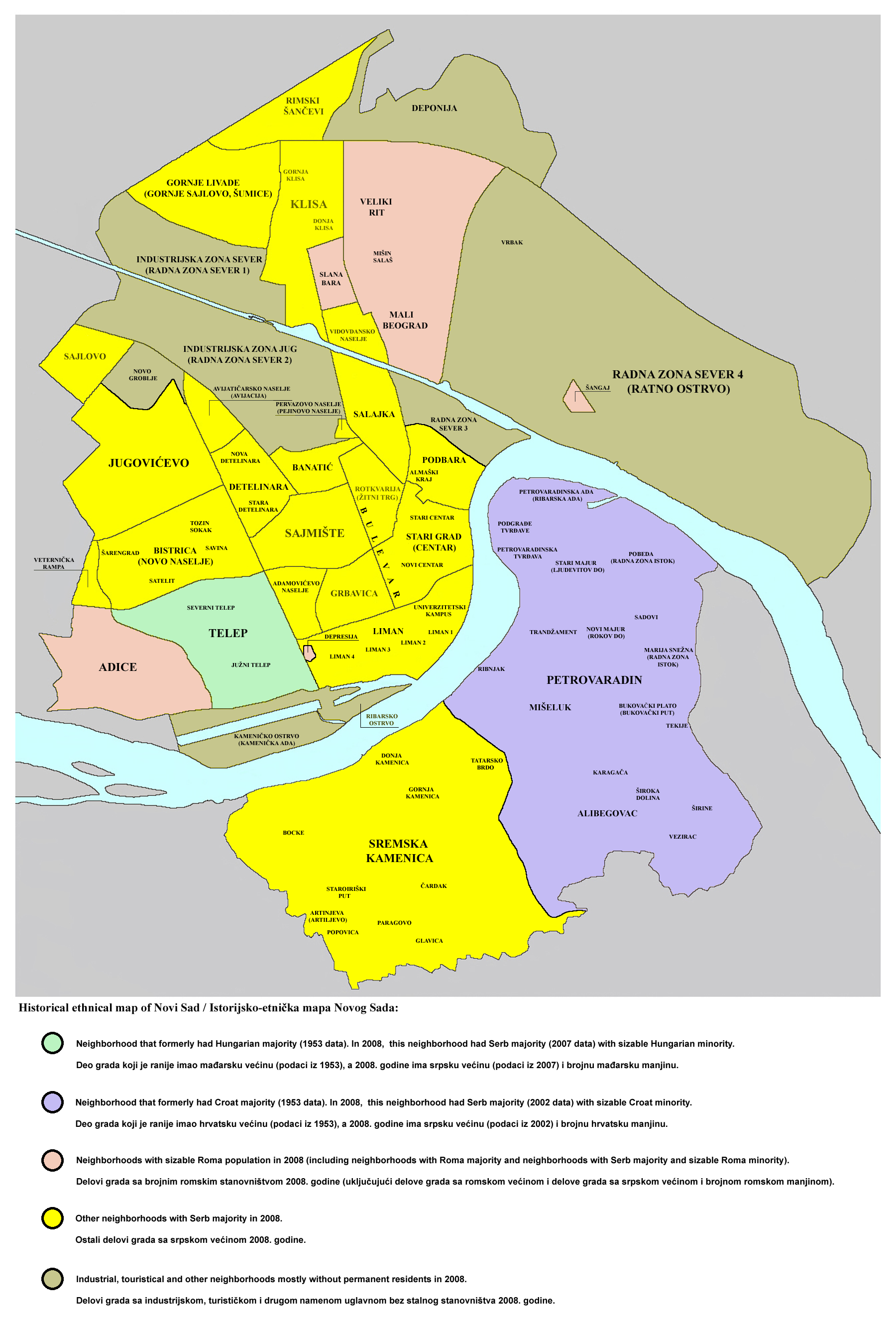
English: Historical ethnical map of Novi Sad (1953-2008).
Српски / srpski: Istorijsko-etnička mapa Novog Sada (1953-2008). |
| Date | 15 November 2008 (original upload date) |
| Source | No machine-readable source provided. Own work assumed (based on copyright claims). |
| Author | No machine-readable author provided. PANONIAN assumed (based on copyright claims). |
Licensing[edit]
my own work
PANONIAN, the copyright holder of this work, hereby publishes it under the following license:
| I, the copyright holder of this work, release this work into the public domain. This applies worldwide. In some countries this may not be legally possible; if so: I grant anyone the right to use this work for any purpose, without any conditions, unless such conditions are required by law. |
References[edit]
- Ferenc Uri, Telep, Enciklopedija Novog Sada, knjiga 28, Novi Sad, 2007.
- Mr Vladimir Stojanović - Dr Dušan Popov, Petrovaradin, Enciklopedija Novog Sada, knjiga 20, Novi Sad, 2002.
- 30 godina mesne zajednice "7. Juli" u Novom Sadu 1974-2004, Monografija, Novi Sad, 2004.
- Popis stanovništva, domaćinstava i stanova u 2002, Stanovništvo - nacionalna ili etnička pripadnost - Podaci po naseljima, knjiga 1, Republika Srbija - Republički zavod za statistiku, Beograd, februar 2003.
- Branko Ćurčin, Slana Bara - nekad i sad, Novi Sad, 2002.
- Branko Ćurčin, Novosadsko naselje Šangaj - nekad i sad, Novi Sad, 2004.
File history
Click on a date/time to view the file as it appeared at that time.
| Date/Time | Thumbnail | Dimensions | User | Comment | |
|---|---|---|---|---|---|
| current | 22:41, 13 September 2010 | | 1,800 × 2,646 (970 KB) | PANONIAN (talk | contribs) | improved version |
| 13:46, 24 November 2009 |  | 1,800 × 2,646 (953 KB) | PANONIAN (talk | contribs) | Reverted to version as of 10:22, 26 September 2009 - fixing thumbnail problem | |
| 13:45, 24 November 2009 |  | 1,800 × 2,386 (1,021 KB) | PANONIAN (talk | contribs) | Reverted to version as of 23:00, 17 February 2009 - fixing thumbnail problem | |
| 10:22, 26 September 2009 |  | 1,800 × 2,646 (953 KB) | PANONIAN (talk | contribs) | ||
| 23:00, 17 February 2009 |  | 1,800 × 2,386 (1,021 KB) | PANONIAN (talk | contribs) | ||
| 18:03, 15 November 2008 |  | 1,800 × 2,386 (1,022 KB) | PANONIAN (talk | contribs) | ==Description== Historical ethnical map of Novi Sad / Istorijsko-etnička mapa Novog Sada == Licensing == my own work {{PD-user|PANONIAN}} Category:Maps of Novi Sad |
You cannot overwrite this file.
File usage on Commons
The following 2 pages use this file:
File usage on other wikis
The following other wikis use this file:
- Usage on bs.wikipedia.org
- Usage on hr.wikipedia.org
- Usage on sr.wikipedia.org