File:New Orleans–Metairie–Slidell combined statistical area.svg
Jump to navigation
Jump to search

Size of this PNG preview of this SVG file: 498 × 599 pixels. Other resolutions: 199 × 240 pixels | 399 × 480 pixels | 638 × 768 pixels | 851 × 1,024 pixels | 1,701 × 2,048 pixels | 997 × 1,200 pixels.
Original file (SVG file, nominally 997 × 1,200 pixels, file size: 1.08 MB)
Captions
Captions
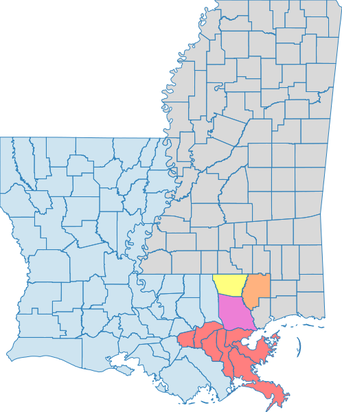
Map of Louisiana (blue) and Mississippi (gray) with the New Orleans–Metairie–Slidell combined statistical area highlighted
Summary[edit]
| Description |
English: Map of Louisiana (blue) and Mississippi (gray) with the New Orleans–Metairie–Slidell combined statistical area highlighted Louisiana
Mississippi
New Orleans–Metairie–Kenner, Louisiana, Metropolitan Statistical Area
Bogalusa, Louisiana, Micropolitan Statistical Area
Slidell–Mandeville–Covington, Louisiana, Metropolitan Statistical Area
Picayune, Mississippi, Micropolitan Statistical Area |
| Date | |
| Source | Own work using U.S Census Bureau KML files |
| Author | Tcr25 |
Licensing[edit]
I, the copyright holder of this work, hereby publish it under the following license:
| This file is made available under the Creative Commons CC0 1.0 Universal Public Domain Dedication. | |
| The person who associated a work with this deed has dedicated the work to the public domain by waiving all of their rights to the work worldwide under copyright law, including all related and neighboring rights, to the extent allowed by law. You can copy, modify, distribute and perform the work, even for commercial purposes, all without asking permission.
|
File history
Click on a date/time to view the file as it appeared at that time.
| Date/Time | Thumbnail | Dimensions | User | Comment | |
|---|---|---|---|---|---|
| current | 12:20, 20 March 2024 | | 997 × 1,200 (1.08 MB) | Tcr25 (talk | contribs) | Uploaded own work with UploadWizard |
You cannot overwrite this file.
File usage on Commons
The following page uses this file:
File usage on other wikis
The following other wikis use this file:
- Usage on en.wikipedia.org
- Usage on www.wikidata.org
Metadata
Categories:
- Maps of census statistical areas in Louisiana
- Maps of census statistical areas in Mississippi
- Maps of Pearl River County, Mississippi
- Maps of Jefferson Parish, Louisiana
- Maps of Orleans Parish, Louisiana
- Maps of Plaquemines Parish, Louisiana
- Maps of Saint Bernard Parish, Louisiana
- Maps of Saint Charles Parish, Louisiana
- Maps of Saint John the Baptist Parish, Louisiana
- Maps of Saint James Parish, Louisiana
- Maps of Saint Tammany Parish, Louisiana
- Maps of Washington Parish, Louisiana