File:Micronesia and Marshall islands bathymetry.pdf
Jump to navigation
Jump to search

Size of this JPG preview of this PDF file: 800 × 518 pixels. Other resolutions: 320 × 207 pixels | 640 × 415 pixels | 1,024 × 663 pixels | 1,280 × 829 pixels | 2,560 × 1,658 pixels | 8,231 × 5,331 pixels.
Original file (8,231 × 5,331 pixels, file size: 16.49 MB, MIME type: application/pdf)
Captions
Captions
Add a one-line explanation of what this file represents
Summary
[edit]| Description |
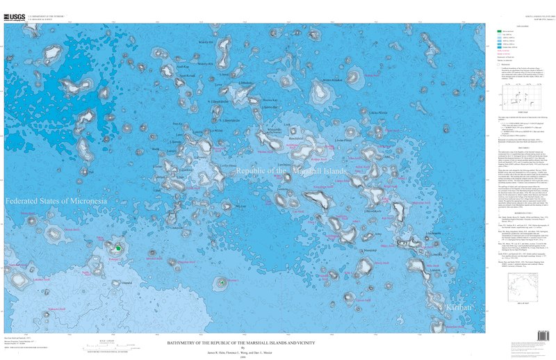
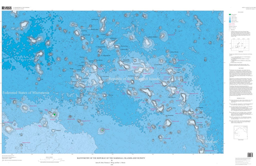
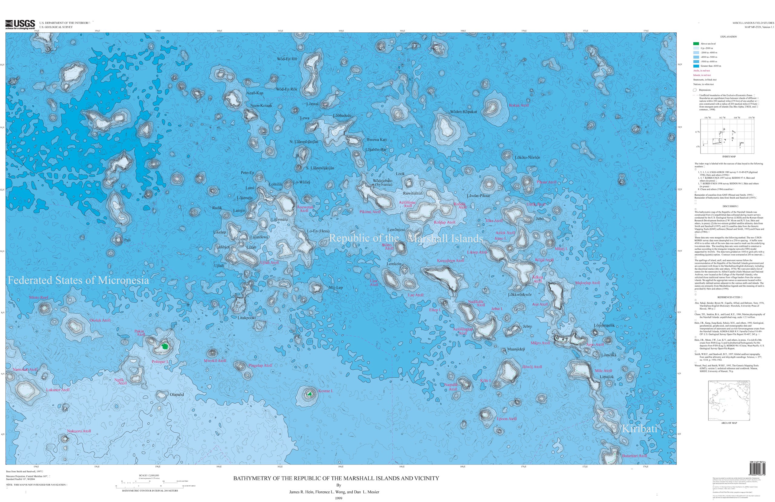
Français : Carte bathymétrique des monts sous-marins et des îles de Micronésie et des Îles Marshall. |
| Date | |
| Source | https://ngmdb.usgs.gov/Prodesc/proddesc_33349.htm |
| Author | James R. Hein, Florence L. Wong, Dan L. Mosier |
Licensing
[edit]This image is in the public domain in the United States because it only contains materials that originally came from the United States Geological Survey, an agency of the United States Department of the Interior. For more information, see the official USGS copyright policy.
|
File history
Click on a date/time to view the file as it appeared at that time.
| Date/Time | Thumbnail | Dimensions | User | Comment | |
|---|---|---|---|---|---|
| current | 19:56, 17 September 2019 |  | 8,231 × 5,331 (16.49 MB) | Sémhur (talk | contribs) | == {{int:filedesc}} == {{Information |Description = A bathymetric map of seamounts and islands in Micronesia and the Marshall Islands |Source = https://ngmdb.usgs.gov/Prodesc/proddesc_33349.htm |Date = 1999 |Author = James R. Hein, Florence L. Wong, Dan L. Mosier }} == {{int:license-header}} == {{PD-USGov-USGS}} Category:Geography of the Marshall Islands Category:Geography of the Federated States of Micronesia |
You cannot overwrite this file.
File usage on Commons
The following 9 pages use this file:
- File:Micronesia and Marshall islands bathymetry, Ioah (IOAN; Fedorov) Guyot.png
- File:Micronesia and Marshall islands bathymetry, Ita Mai Tai Guyot.png
- File:Micronesia and Marshall islands bathymetry, Lo-En (Hess) Guyot.png
- File:Micronesia and Marshall islands bathymetry, Lomilik and Ļami.png
- File:Micronesia and Marshall islands bathymetry, Pako (Pallada) Guyot.png
- File:Micronesia and Marshall islands bathymetry, Ruwitūn̄tūn̄ Guyot.png
- File:Micronesia and Marshall islands bathymetry, Ujlān volcanic complex.png
- File:Micronesia and Marshall islands bathymetry, Wōdejebato (Sylvania) Guyot.png
- File:Micronesia and Marshall islands bathymetry, Ļemkein.png
_Guyot.png)
_Guyot.png)
_Guyot.png)
_Guyot.png)
File usage on other wikis
The following other wikis use this file:
- Usage on de.wikipedia.org
- Usage on en.wikipedia.org
- Usage on fr.wikipedia.org
- Usage on ru.wikipedia.org