File:Messnetzkarte boden DWD 2019-02-12.pdf

From Wikimedia Commons, the free media repository
Jump to navigation Jump to search

Original file(4,966 × 7,020 pixels, file size: 2.44 MB, MIME type: application/pdf)

Captions

Captions

Add a one-line explanation of what this file represents

Summary[edit]

Description
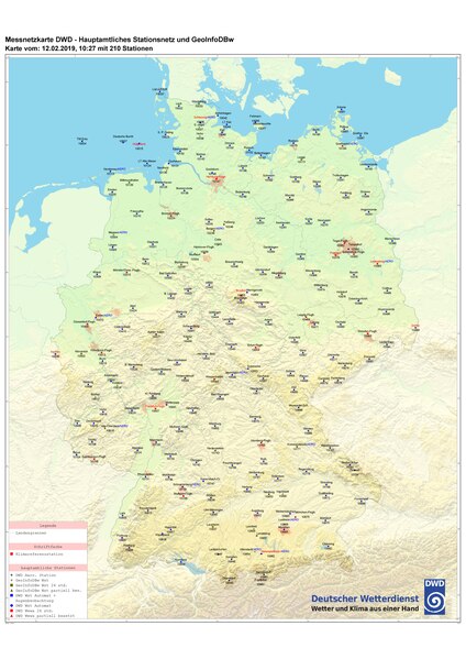
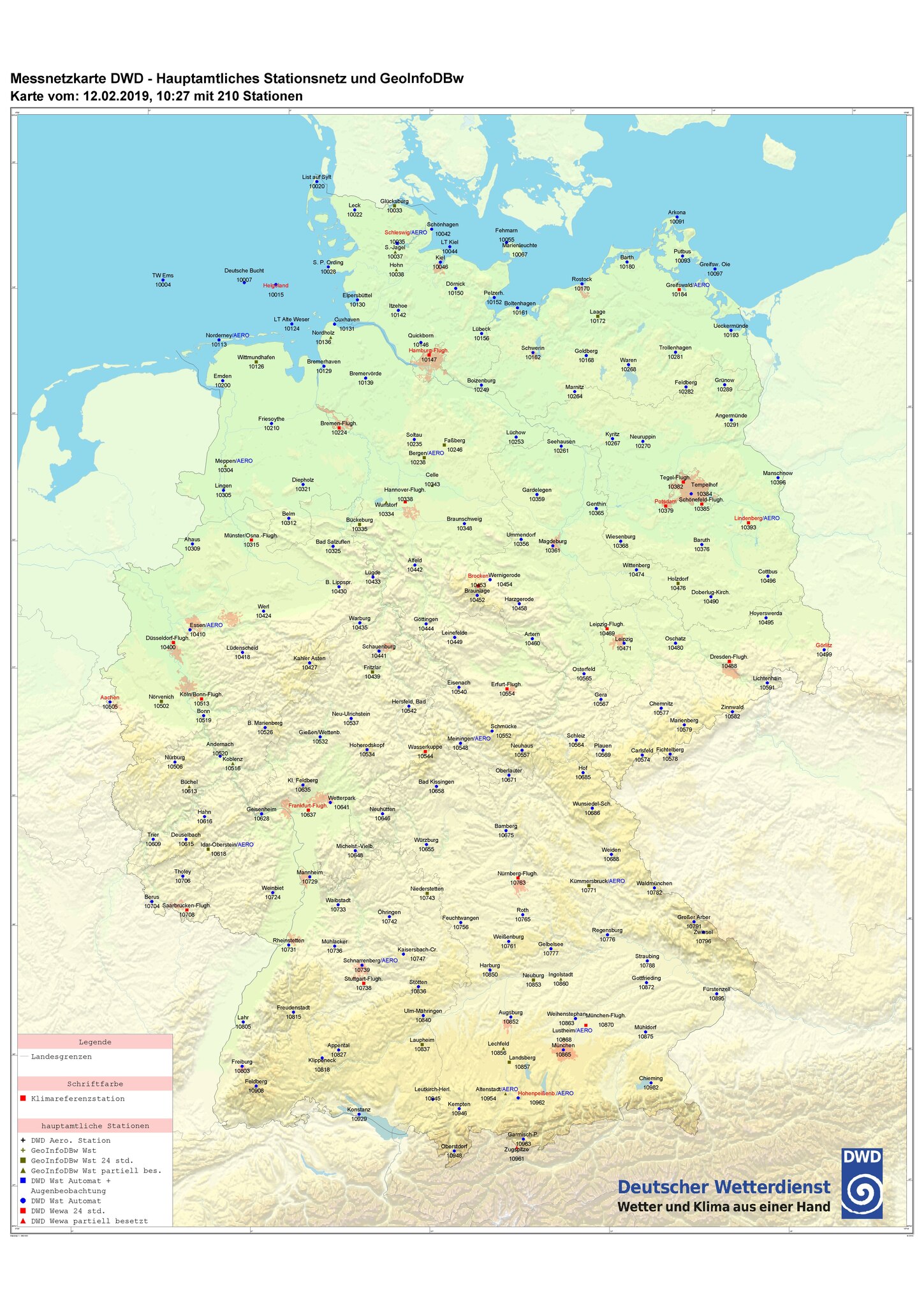
Deutsch: Messnetzkarte DWD - Hauptamtliches Stationsnetz und GeoInfoDBw; Karte vom 12.02.2019 mit 210 Stationen
Date
Source DWD
Author
This file could be used under the terms of the Verordnung zur Festlegung der Nutzungsbestimmungen für die Bereitstellung von Geodaten des Bundes. The summary below is not official. For an english translation see Ordinance to Determine the Conditions for Use for the Provision of Spatial Data of the Federation.

You are free:

  • to copy, print, present, alter, process and transmit this work to third parties for commercial and non-commercial use
  • to merge this work with own data and with the data of others and to combine it to form new and independent datasets
  • to integrate this work in internal and external business processes, products and applications in public and non-public electronic networks

Under the following conditions:

  • You have to guarantee that all source notices, which are in the geodata, metadata or geodata service, or other legal notices are recognizable integrated in the optical background
  • You have to guarantee that all changes, deratived, new designs, or other variants be provided with a changing notice in the source notice
  • You have to guarantee that, if geodata holding authority requests this, the source notice will be deleted

Permission
(Reusing this file)
This file could be used under the terms of the Verordnung zur Festlegung der Nutzungsbestimmungen für die Bereitstellung von Geodaten des Bundes. The summary below is not official. For an english translation see Ordinance to Determine the Conditions for Use for the Provision of Spatial Data of the Federation.

You are free:

  • to copy, print, present, alter, process and transmit this work to third parties for commercial and non-commercial use
  • to merge this work with own data and with the data of others and to combine it to form new and independent datasets
  • to integrate this work in internal and external business processes, products and applications in public and non-public electronic networks

Under the following conditions:

  • You have to guarantee that all source notices, which are in the geodata, metadata or geodata service, or other legal notices are recognizable integrated in the optical background
  • You have to guarantee that all changes, deratived, new designs, or other variants be provided with a changing notice in the source notice
  • You have to guarantee that, if geodata holding authority requests this, the source notice will be deleted

Licensing[edit]

Public domain This image is in the public domain according to German copyright law because it is part of a statute, ordinance, official decree or judgment (official work) issued by a German authority or court (§ 5 Abs.1 UrhG).

dansk  Deutsch  English  español  Esperanto  français  italiano  Malti  Nederlands  polski  sicilianu  suomi  svenska  Tiếng Việt  македонски  русский  українська  বাংলা  日本語  中文(简体)  中文(繁體)  العربية  +/−

File history

Click on a date/time to view the file as it appeared at that time.

Date/TimeThumbnailDimensionsUserComment
current13:56, 2 June 2020Thumbnail for version as of 13:56, 2 June 20204,966 × 7,020 (2.44 MB)Woelle ffm (talk | contribs){{Information |description ={{de|1=Messnetzkarte DWD - Hauptamtliches Stationsnetz und GeoInfoDBw; Karte vom 12.02.2019 mit 210 Stationen}} |date =2019-02-12 |source =DWD |author ={{GeoNutzV}} |permission ={{GeoNutzV}} }} Category:Weather stations Category:Weather stations in Germany Category:Weather stations of Deutscher Wetterdienst in Germany

The following page uses this file:

File usage on other wikis

The following other wikis use this file:

Metadata