File:Map of the southern Balkans, 1410-es.svg
Jump to navigation
Jump to search

Size of this PNG preview of this SVG file: 679 × 600 pixels. Other resolutions: 272 × 240 pixels | 543 × 480 pixels | 869 × 768 pixels | 1,159 × 1,024 pixels | 2,318 × 2,048 pixels | 2,217 × 1,959 pixels.
Original file (SVG file, nominally 2,217 × 1,959 pixels, file size: 2.76 MB)
Captions
Captions
Add a one-line explanation of what this file represents
Summary
[edit]
| Description |
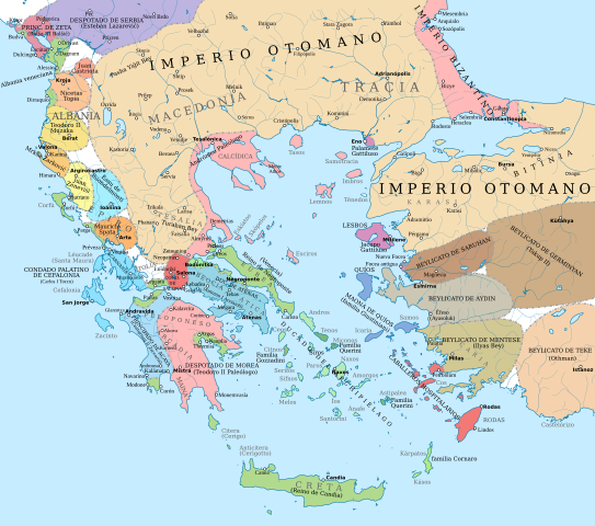
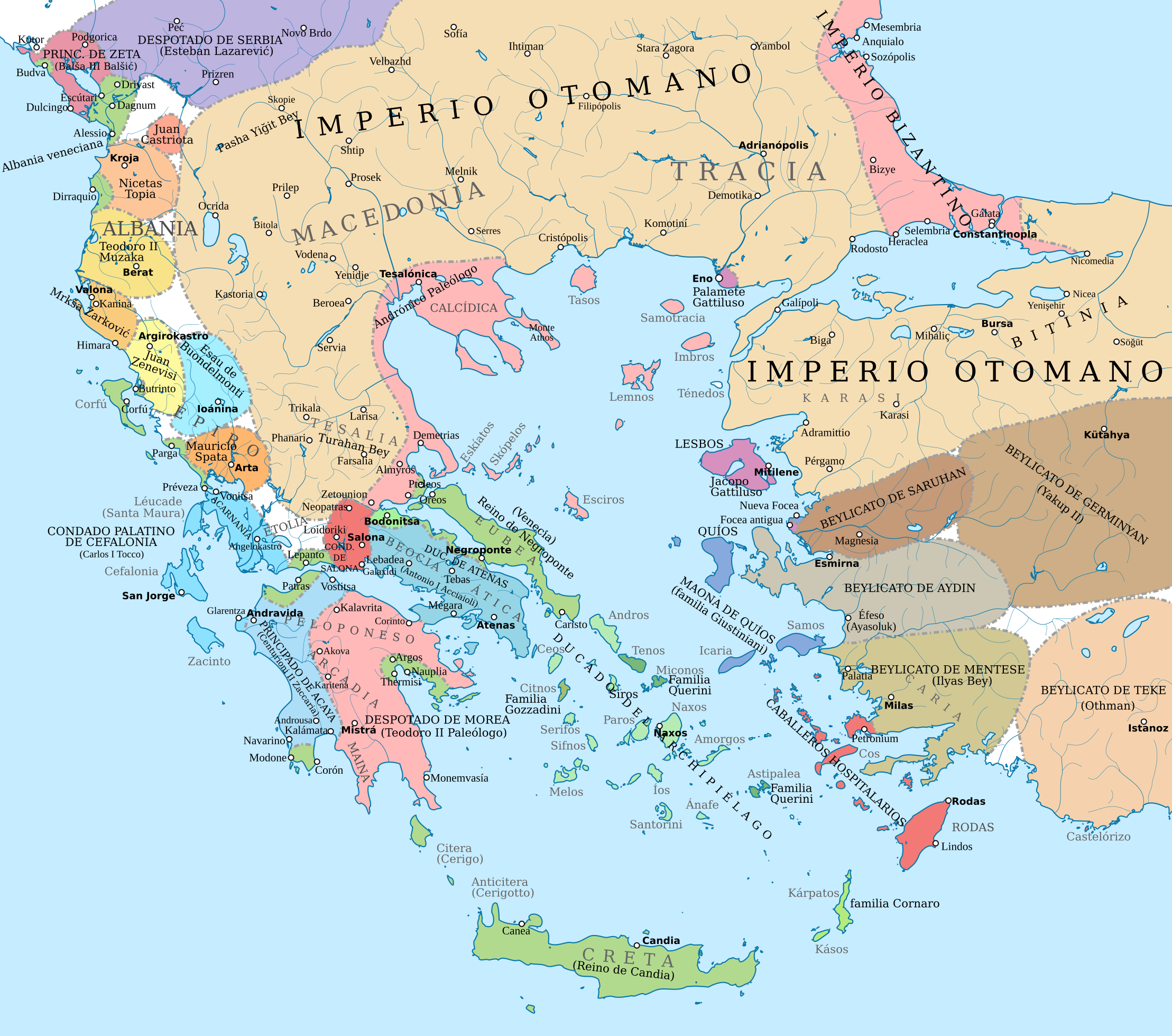
English: Political map of the southern Balkans and western Anatolia in 1410. Disclaimer: The borders shown are often uncertain and conjectural; an effort has been made to be as accurate as possible and follow the relevant scholarship, but errors or omissions may still be present. Any help in correcting and/or improving this work would be greatly appreciated.
Sources: Basic map sources:
Southern Greece and Latin states in the Aegean and the Balkans:
Epirus, Albania, Montenegro:
Northern Greece:
Boundaries of the Byzantine Empire:
Ottoman Empire and Anatolian beyliks:
|
| Source |
This file was derived from: Map of the southern Balkans, 1410.svg |
| Author | Constantine Plakidas |
Licensing
[edit]
This file is licensed under the Creative Commons Attribution-Share Alike 4.0 International license.
- You are free:
- to share – to copy, distribute and transmit the work
- to remix – to adapt the work
- Under the following conditions:
- attribution – You must give appropriate credit, provide a link to the license, and indicate if changes were made. You may do so in any reasonable manner, but not in any way that suggests the licensor endorses you or your use.
- share alike – If you remix, transform, or build upon the material, you must distribute your contributions under the same or compatible license as the original.
File history
Click on a date/time to view the file as it appeared at that time.
| Date/Time | Thumbnail | Dimensions | User | Comment | |
|---|---|---|---|---|---|
| current | 06:43, 23 August 2021 | | 2,217 × 1,959 (2.76 MB) | Rowanwindwhistler (talk | contribs) | Background updated from source map |
| 16:41, 16 July 2019 |  | 2,217 × 1,959 (2.76 MB) | Rowanwindwhistler (talk | contribs) | Uploading a file from a free published source using File Upload Wizard |
You cannot overwrite this file.
File usage on Commons
The following page uses this file:
File usage on other wikis
The following other wikis use this file:
- Usage on es.wikipedia.org
- Usage on fr.wikipedia.org
Metadata
Categories:
- Maps showing 15th-century history
- Maps of the history of the Ottoman Empire in the 1410s
- Maps of the Byzantine empire in the 15th century
- Maps of the history of the medieval Balkans
- 1410
- Maps of the Duchy of Athens
- Maps of the Principality of Achaea
- Maps of Anatolian beyliks
- Maps of the Duchy of the Archipelago
- Stato da Màr
- Spanish-language SVG maps showing history