File:Map of the rebel fortifications at Columbus, Ky. LOC 2009581441.jpg
Jump to navigation
Jump to search

Size of this preview: 621 × 600 pixels. Other resolutions: 248 × 240 pixels | 497 × 480 pixels | 795 × 768 pixels | 1,060 × 1,024 pixels | 2,120 × 2,048 pixels | 6,195 × 5,985 pixels.
Original file (6,195 × 5,985 pixels, file size: 4.29 MB, MIME type: image/jpeg)
Captions
Captions
Add a one-line explanation of what this file represents
Summary[edit]
| Description |
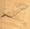
English: Relief shown by hachures and spot heights. Finished manuscript map of Columbus and vicinity, Ky., displaying roads, city streets without names, buildings, drainage, some vegetation, "Mobile and Ohio R.R.," and the location of "abattis or felled trees" which obstructed the approaches to the fortifications. In the lower right corner: Engr. Dept. July 18/64. Recd. with Gen. Cullum's letter of the 16th inst. (C.5621). LC Civil War Maps (2nd ed.), 216.95 Description derived from published bibliography. Available also through the Library of Congress Web site as a raster image. Includes six "Cross sections of the different intrenchments" and a list of references. |
||
| Title | Map of the rebel fortifications at Columbus, Ky. | ||
| Shelf ID | G3954.C515S5 1862 .C8 | ||
| Date | |||
| Source | https://www.loc.gov/item/2009581441/ | ||
| Author | Cullum, George W. (George Washington); Cullum, George W. | ||
| Permission (Reusing this file) |
|
||
| Other versions |
|
||
| Location | United States · Columbus Region · Kentucky | ||
| Part of | Military Battles And Campaigns · American Memory · Civil War Maps · Catalog · Geography And Map Division | ||
| Subject | Maps, Manuscript · Fortification · Columbus Region · Kentucky · United States · Maps · Civil War · Columbus Region (Ky.) · History |

Licensing[edit]
|
This is a faithful photographic reproduction of a two-dimensional, public domain work of art. The work of art itself is in the public domain for the following reason:
The official position taken by the Wikimedia Foundation is that "faithful reproductions of two-dimensional public domain works of art are public domain".
This photographic reproduction is therefore also considered to be in the public domain in the United States. In other jurisdictions, re-use of this content may be restricted; see Reuse of PD-Art photographs for details. | ||||
File history
Click on a date/time to view the file as it appeared at that time.
| Date/Time | Thumbnail | Dimensions | User | Comment | |
|---|---|---|---|---|---|
| current | 03:41, 21 June 2018 | | 6,195 × 5,985 (4.29 MB) | Fæ (talk | contribs) | LOC Maps https://www.loc.gov/item/2009581441/ #22742 |
You cannot overwrite this file.
File usage on Commons
The following page uses this file: