File:Map of Darwin (Palmerston) railway station, 1895.tif
Jump to navigation
Jump to search

Size of this PNG preview of this TIF file: 377 × 599 pixels. Other resolutions: 151 × 240 pixels | 302 × 480 pixels | 483 × 768 pixels | 645 × 1,024 pixels | 1,422 × 2,258 pixels.
Original file (1,422 × 2,258 pixels, file size: 12.25 MB, MIME type: image/tiff)
Captions
Captions
Map of Darwin (then named Palmerston) railway station, 1895, superimposed on a contemporary map of central Darwin
Summary[edit]
| Description |
English: Map of layout of Darwin (then named Palmerston) railway station, 1895, superimposed on a contemporary map of central Darwin |
| Date | |
| Source | https://www.openstreetmap.org/#map=16/-12.4637/130.8426&layers=T (map underlay) |
| Author | OpenStreetMap contributors (map underlay – CC BY); SCHolar44 (other artwork – CC0) |
| Camera location | | View this and other nearby images on: OpenStreetMap |
|---|
Licensing[edit]
This file is licensed under the Creative Commons Attribution 4.0 International license.
- You are free:
- to share – to copy, distribute and transmit the work
- to remix – to adapt the work
- Under the following conditions:
- attribution – You must give appropriate credit, provide a link to the license, and indicate if changes were made. You may do so in any reasonable manner, but not in any way that suggests the licensor endorses you or your use.
File history
Click on a date/time to view the file as it appeared at that time.
| Date/Time | Thumbnail | Dimensions | User | Comment | |
|---|---|---|---|---|---|
| current | 08:22, 13 January 2023 |  | 1,422 × 2,258 (12.25 MB) | SCHolar44 (talk | contribs) | Cropped 14 % horizontally, 3 % vertically using CropTool with precise mode. |
| 09:29, 27 June 2021 |  | 1,653 × 2,338 (14.75 MB) | SCHolar44 (talk | contribs) | Reverted to version as of 09:06, 27 June 2021 (UTC). Most recent version. | |
| 09:27, 27 June 2021 | 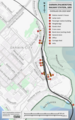 | 1,412 × 2,252 (12.13 MB) | SCHolar44 (talk | contribs) | Reverted to version as of 02:48, 21 June 2021 (UTC); I uploaded the irrelevant image by accident. | |
| 09:06, 27 June 2021 | 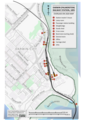 | 1,653 × 2,338 (14.75 MB) | SCHolar44 (talk | contribs) | Added source of station track layout detail, overlooked when I uploaded the 1st version. | |
| 08:59, 27 June 2021 |  | 1,653 × 2,338 (14.75 MB) | SCHolar44 (talk | contribs) | Added source of station track layout detail, overlooked when I uploaded the 1st version. | |
| 02:48, 21 June 2021 |  | 1,412 × 2,252 (12.13 MB) | SCHolar44 (talk | contribs) | Uploaded a work by OpenStreetMap contributors (map underlay – CC BY); SCHolar44 (other artwork – CC0) from https://www.openstreetmap.org/#map=16/-12.4637/130.8426&layers=T (map underlay) with UploadWizard |
You cannot overwrite this file.
File usage on Commons
The following 3 pages use this file: