File:Map european russia volgograd.png
Jump to navigation
Jump to search
No higher resolution available.
Map_european_russia_volgograd.png (230 × 223 pixels, file size: 14 KB, MIME type: image/png)
Captions
Captions
Add a one-line explanation of what this file represents
Summary[edit]
| Description | |
| Source |
This file was derived from: Rs-map.png |
| Author |
Licensing[edit]
This image is in the public domain because it contains materials that originally came from the United States Central Intelligence Agency's World Factbook.
|
 |
Original upload log[edit]
The original description page was here. All following user names refer to en.wikipedia.
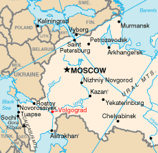
- 2005-05-03 23:10 ChrisO~enwiki 230×223× (13911 bytes) Map of European [[Russia]] showing the location of [[Volgograd]] Adapted from http://en.wikipedia.org/wiki/Image:Rs-map.png {{PD-USGov-CIA-WF}}
The original description page was here. All following user names refer to ro.wikipedia.
| Date/Time | Dimensions | User | Comment |
|---|---|---|---|
| 2006-09-25 17:28 | 230×223× (13911 bytes) | Vali | Harta Rusiei europene cu indicarea locaţiei Volgogradului. Adaptată de pe http://en.wikipedia.org/wiki/Image:Rs-map.png |
File history
Click on a date/time to view the file as it appeared at that time.
| Date/Time | Thumbnail | Dimensions | User | Comment | |
|---|---|---|---|---|---|
| current | 17:03, 10 November 2014 | | 230 × 223 (14 KB) | Strainu (talk | contribs) | Transferred from ro.wikipedia |
You cannot overwrite this file.
File usage on Commons
The following 2 pages use this file:
File usage on other wikis
The following other wikis use this file:
- Usage on en.wikipedia.org
- Usage on fa.wikipedia.org
- Usage on pl.wikivoyage.org
- Usage on pnb.wikipedia.org
- Usage on ro.wikipedia.org