File:Map Lesotho SRTM.pdf
Jump to navigation
Jump to search

Size of this JPG preview of this PDF file: 800 × 565 pixels. Other resolutions: 320 × 226 pixels | 640 × 452 pixels | 1,024 × 723 pixels | 1,280 × 904 pixels | 1,754 × 1,239 pixels.
Original file (1,754 × 1,239 pixels, file size: 1.88 MB, MIME type: application/pdf)
Captions
Captions
Add a one-line explanation of what this file represents

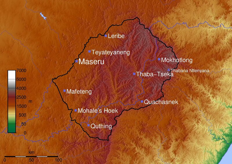
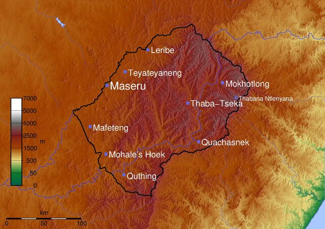
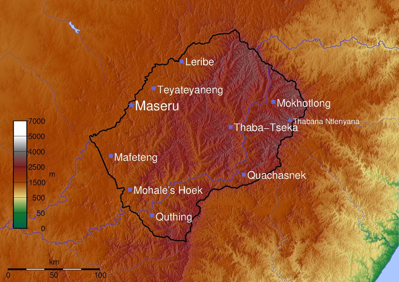
Topographical map of Lesotho.
© 2005 Médéric Boquien (Med)
Topography: National Geospatial-Intelligence Agency and NASA, [1]
Mapping: Generic Mapping Tools.
This file is licensed under the Creative Commons Attribution-Share Alike 2.0 Generic license.
- You are free:
- to share – to copy, distribute and transmit the work
- to remix – to adapt the work
- Under the following conditions:
- attribution – You must give appropriate credit, provide a link to the license, and indicate if changes were made. You may do so in any reasonable manner, but not in any way that suggests the licensor endorses you or your use.
- share alike – If you remix, transform, or build upon the material, you must distribute your contributions under the same or compatible license as the original.
#!/bin/sh
RFLAG="-R26/30.5/-31.05/-28.2"
FORMAT=""
PROJECTION="$RFLAG -JM29.7 $FORMAT"
CITY_TEXT_COLOR=255/255/255
CITY_SYMBOL="-Ss.4 -G102/102/220"
CAPITAL_SYMBOL="-Sa.5 -G102/102/220"
PEAK_SYMBOL="-St.4 -G102/102/220"
PALETTE=mountains2.cpt

PSFILE=lesotho.ps
PNGFILE=lesotho.png

gmtset ANNOT_FONT_SIZE 16p LABEL_FONT_SIZE 16p
grdgradient sortie.grd -Ne.3 -A100 -M -GLesotho_i5.grd
grdimage -Ei -ILesotho_i5.grd -C$PALETTE $PROJECTION sortie.grd -K > $PSFILE

RIVERS="\
  -I1/0.5p/50/50/255\
  -I2/0.4p/50/50/255\
  -I3/0.3p/50/50/255\
  -I4/0.2p/50/50/255\
  -I5/0.4p,-/50/50/255\
  -I6/0.3p,-/50/50/255\
  -I7/0.2p,-/50/50/255\
  -I8/1p/50/50/255"

SCALE=-Lfx4/1/-29.7/100k

pscoast $PROJECTION\
  -Df \
  -W0.5p/100/100/200 \
  -N1/2p \
  -S170/200/255\
  $SCALE\
   -O -K\
  >> $PSFILE

psscale -D1/8/8/1 -C$PALETTE -B:m: -L -O -K $FORMAT >>$PSFILE

recode utf8..iso8859-1 < lesotho_cities.txt | psxy  $PROJECTION $CITY_SYMBOL -O -K >> $PSFILE
recode utf8..iso8859-1 < lesotho_capital.txt | psxy  $PROJECTION $CAPITAL_SYMBOL -O -K >> $PSFILE
recode utf8..iso8859-1 < lesotho_peaks.txt | psxy  $PROJECTION $PEAK_SYMBOL -O -K >> $PSFILE

recode utf8..iso8859-1 < lesotho_cities.txt | pstext $PROJECTION -G$CITY_TEXT_COLOR -Dj0.25 -O  -K >> $PSFILE
recode utf8..iso8859-1 < lesotho_capital.txt | pstext $PROJECTION -G$CITY_TEXT_COLOR -Dj0.25 -O -K  >> $PSFILE
recode utf8..iso8859-1 < lesotho_peaks.txt | pstext $PROJECTION -G$CITY_TEXT_COLOR -Dj0.25 -O  >> $PSFILE

epstopdf $PSFILE
GS_OPTIONS="-dTextAlphaBits=2 -dGraphicsAlphaBits=2"
export GS_OPTIONS
pstopnm -portrait -ysize=2048 -xborder=0 -yborder=0 -stdout -ppm  $PSFILE | pnmtopng > $PNGFILE
#File mountains2.cpt
#COLOR_MODEL = RGB
#
0       0       97      71      50      16      122     47
50      16      122     47      500     232     215     125
500     232     215     125     1500    161     67      0
1500    161     67      0       2500    130     30      30
2500    130     30      30      4000    110     110     110
4000    110     110     110     5000    255     255     255
5000    255     255     255     7000    255     255     255
N 0 97 71
F 255 0 0
B 0 97 71
lesotho_capital.txt:
27.4833333 -29.3166667 28 0 0 LM Maseru
lesotho_cities.txt:
27.7333333  -29.15 22 0 0 LM Teyateyaneng
28.05  -28.8833333 22 0 0 LM Leribe
29.0833333  -29.2833333 22 0 0 LM Mokhotlong
28.6  -29.5333333 22 0 0 LM Thaba-Tseka
28.75  -30.0 22 0 0 LM Quachasnek
27.7166667  -30.4 22 0 0 LM Quthing
27.4666667  -30.15 22 0 0 LM Mohale's Hoek
27.25  -29.8166667 22 0 0 LM Mafeteng
lesotho_peaks.txt:
29.2666667 -29.4666667 16 0 0 LM Thabana Ntlenyana
File history
Click on a date/time to view the file as it appeared at that time.
| Date/Time | Thumbnail | Dimensions | User | Comment | |
|---|---|---|---|---|---|
| current | 21:43, 12 June 2005 |  | 1,754 × 1,239 (1.88 MB) | Med (talk | contribs) | 450px|right|Topographical map of Lesotho Topographical map of Lesotho. © 2005 Médéric Boquien (Med) '''Topography:''' National Geospatial-Intelligence Agency |
You cannot overwrite this file.
File usage on Commons
There are no pages that use this file.
File usage on other wikis
The following other wikis use this file:
- Usage on nl.wikipedia.org