File:Map France 1030-de.svg
Jump to navigation
Jump to search

Size of this PNG preview of this SVG file: 527 × 600 pixels. Other resolutions: 211 × 240 pixels | 422 × 480 pixels | 675 × 768 pixels | 900 × 1,024 pixels | 1,800 × 2,048 pixels | 988 × 1,124 pixels.
Original file (SVG file, nominally 988 × 1,124 pixels, file size: 1.49 MB)
Captions
Captions
Add a one-line explanation of what this file represents
Summary[edit]
| Description |
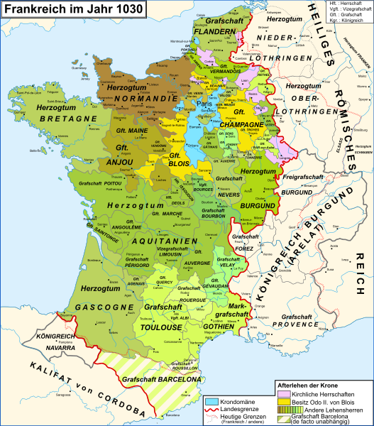
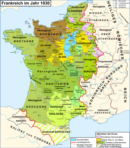
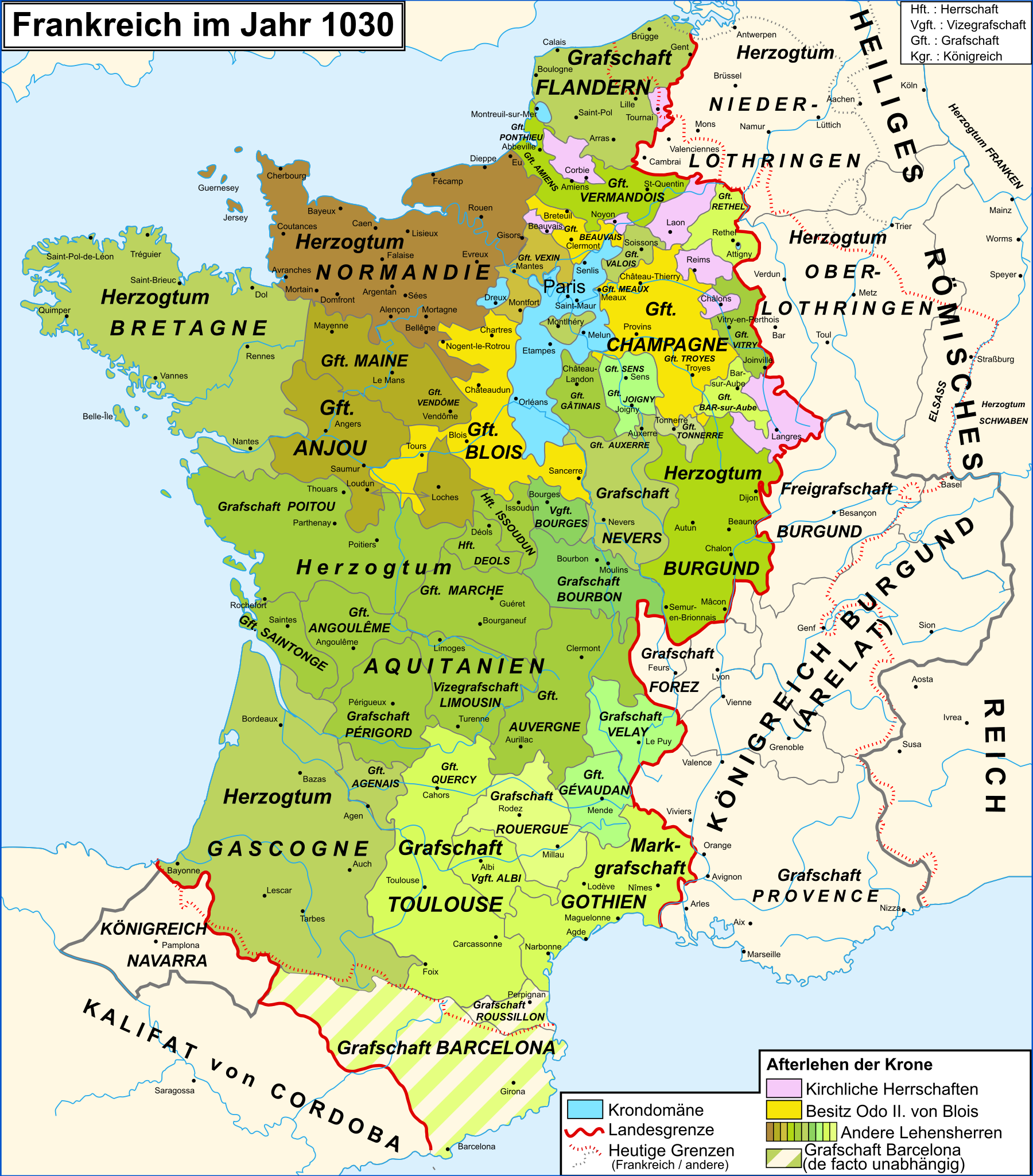
Deutsch: Karte Frankreichs im Jahr 1030
Français : Carte de la France en 1030
English: Map of the France in 1030 |
| Date | (UTC) |
| Source | |
| Author |
|
| Other versions |
[]
|
| SVG development | This vector image was created with Adobe Illustrator. |


Legende[edit]
| This is a retouched picture, which means that it has been digitally altered from its original version. Modifications: traduction allemand/deutsche Übersetzung/German translation. The original can be viewed here: Map France 1030-fr.svg:
|
Licensing[edit]
I, the copyright holder of this work, hereby publish it under the following licenses:
This file is licensed under the Creative Commons Attribution-Share Alike 3.0 Unported, 2.5 Generic, 2.0 Generic and 1.0 Generic license.
- You are free:
- to share – to copy, distribute and transmit the work
- to remix – to adapt the work
- Under the following conditions:
- attribution – You must give appropriate credit, provide a link to the license, and indicate if changes were made. You may do so in any reasonable manner, but not in any way that suggests the licensor endorses you or your use.
- share alike – If you remix, transform, or build upon the material, you must distribute your contributions under the same or compatible license as the original.

|
Permission is granted to copy, distribute and/or modify this document under the terms of the GNU Free Documentation License, Version 1.2 or any later version published by the Free Software Foundation; with no Invariant Sections, no Front-Cover Texts, and no Back-Cover Texts. A copy of the license is included in the section entitled GNU Free Documentation License. |
You may select the license of your choice.
Original upload log[edit]
This image is a derivative work of the following images:
- File:Map_France_1030-fr.svg licensed with Cc-by-sa-3.0,2.5,2.0,1.0, GFDL
- 2010-10-19T16:47:44Z Sxilderik 988x1124 (832361 Bytes) ajouté quelques accents ( PERIGORD, ... )
- 2009-01-23T15:29:02Z Zigeuner 988x1124 (832365 Bytes) Légendes déplacées
- 2009-01-23T15:05:05Z Zigeuner 988x1124 (826462 Bytes) Marquisat de Gothie : même couleur que le comté de Toulouse Comté de Barcelone : + hachures Iles atlantiques : + couleurs
- 2008-06-18T20:16:34Z Zigeuner 988x1124 (810778 Bytes) {{Information |Description={{en|1=Map of the France in 1030}} {{fr|1=Carte de la France en 1030}} |Source=travail personnel (own work) [http://www.lib.utexas.edu/maps/historical/shepherd_1911/shepherd-c-061.jpg] |Author=[[Use
Uploaded with derivativeFX
File history
Click on a date/time to view the file as it appeared at that time.
| Date/Time | Thumbnail | Dimensions | User | Comment | |
|---|---|---|---|---|---|
| current | 21:06, 23 August 2016 | | 988 × 1,124 (1.49 MB) | Furfur (talk | contribs) | SVG aufgeräumt, jetzt valides SVG, Dateigröße signifikant kleiner |
| 21:12, 25 December 2011 |  | 988 × 1,124 (1.96 MB) | Furfur (talk | contribs) | Details | |
| 20:42, 25 December 2011 |  | 988 × 1,124 (1.96 MB) | Furfur (talk | contribs) | == {{int:filedesc}} == {{Information |Description={{de|1=Karte Frankreichs im Jahr 1030}} {{fr|1=Carte de la France en 1030}} {{en|1=Map of the France in 1030}} |Source=*File:Map_France_1030-fr.svg |Date=2011-12-25 20:39 (UTC) |Author=*[[:File:Map_F |
You cannot overwrite this file.
File usage on Commons
The following 9 pages use this file:
File usage on other wikis
The following other wikis use this file:
- Usage on de.wikipedia.org
- Usage on et.wikipedia.org
- Usage on la.wikipedia.org
- Usage on sl.wikipedia.org
Metadata
Categories:
- Maps showing 1030
- Maps of 11th-century France
- Maps showing 11th-century history
- SVG maps of the history of France
- German-language SVG maps showing history
- County of Champagne
- Maps of the county of Flanders
- Duchy of Burgundy
- County of Burgundy
- Kingdom of Burgundy
- Duchy of Brittany
- Duchy of Normandy
- Maps of the history of Lorraine
- Maine (province)
- County of Anjou
- Marche (province)
- Nivernais
- Bourbonnais
- Maps of Poitou
- Angoumois
- Saintonge
- County of Auvergne
- Forez
- Maps of Limousin
- Maps of the history of Provence
- Kingdom of Navarre
- Maps of the County of Barcelona
- County of Toulouse
- Maps of Gascogne
- Maps of the Kingdom of France
- Roussillon