File:MPR-coverage in cold war Germany.svg
Jump to navigation
Jump to search

Size of this PNG preview of this SVG file: 506 × 599 pixels. Other resolutions: 203 × 240 pixels | 405 × 480 pixels | 648 × 768 pixels | 865 × 1,024 pixels | 1,729 × 2,048 pixels | 1,075 × 1,273 pixels.
Original file (SVG file, nominally 1,075 × 1,273 pixels, file size: 491 KB)
Captions
Captions
Add a one-line explanation of what this file represents
| Description |
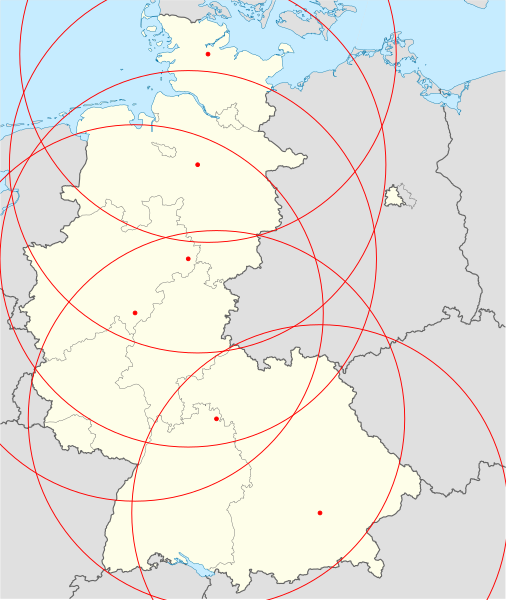
Deutsch: Positionskarte mit Radarabdeckung (Schema) der MPR-Radargeräte in Deutschland zur Zeit des Kalten Krieges. Gebietsstand zwischen Januar 1957 bis Oktober 1990. |
| Date | (UTC) |
| Source | |
| Author |
|
| This is a retouched picture, which means that it has been digitally altered from its original version. Modifications: approx. RADAR-coverage of MPR added. The original can be viewed here: Germany, Federal Republic of location map January 1957 - October 1990.svg:
|
I, the copyright holder of this work, hereby publish it under the following licenses:
This file is licensed under the Creative Commons Attribution-Share Alike 3.0 Unported license.
- You are free:
- to share – to copy, distribute and transmit the work
- to remix – to adapt the work
- Under the following conditions:
- attribution – You must give appropriate credit, provide a link to the license, and indicate if changes were made. You may do so in any reasonable manner, but not in any way that suggests the licensor endorses you or your use.
- share alike – If you remix, transform, or build upon the material, you must distribute your contributions under the same or compatible license as the original.

|
Permission is granted to copy, distribute and/or modify this document under the terms of the GNU Free Documentation License, Version 1.2 or any later version published by the Free Software Foundation; with no Invariant Sections, no Front-Cover Texts, and no Back-Cover Texts. A copy of the license is included in the section entitled GNU Free Documentation License. |
You may select the license of your choice.
Original upload log[edit]
This image is a derivative work of the following images:
- File:Germany,_Federal_Republic_of_location_map_January_1957_-_October_1990.svg licensed with Cc-by-sa-3.0, GFDL
- 2009-01-18T03:25:19Z TUBS 1075x1273 (501729 Bytes) {{Information |Description=Germany,_Federal_Republic_of__location_map_April_1952_-_August_1955 |Source=own work |Date=2009 |Author=[[Author:TUBS]] |Permission= |other_versions= }}
Uploaded with derivativeFX
File history
Click on a date/time to view the file as it appeared at that time.
| Date/Time | Thumbnail | Dimensions | User | Comment | |
|---|---|---|---|---|---|
| current | 19:08, 11 August 2010 | | 1,075 × 1,273 (491 KB) | Gomera-b (talk | contribs) | {{Information |Description={{de|Positionskarte mit Radarabdeckung (ungefahr) der MPR-Radargeräte in Bundesrepublik Deutschland zur Zeit des Kalten Krieges. Gebietsstand zwischen Januar 1957 bis Oktober 1990.}} |S |
You cannot overwrite this file.
File usage on Commons
There are no pages that use this file.