File:Linha do Minho de.svg
Jump to navigation
Jump to search

Size of this PNG preview of this SVG file: 246 × 598 pixels. Other resolutions: 98 × 240 pixels | 197 × 480 pixels | 316 × 768 pixels | 421 × 1,024 pixels | 842 × 2,048 pixels | 856 × 2,081 pixels.
Original file (SVG file, nominally 856 × 2,081 pixels, file size: 7.49 MB)
Captions
Captions
Add a one-line explanation of what this file represents
| Description |
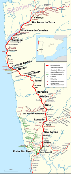
Deutsch: Karte der Linha do Minho, deutsche Legende Português: Mapa da Linha do Minho, Índice em alemão |
|||||||||
| Date | ||||||||||
| Source | Open Street Map | |||||||||
| Creator | ||||||||||
| Permission (Reusing this file) |
Map data (c) OpenStreetMap (and) contributors, CC-BY-SA | |||||||||
| Geotemporal data | ||||||||||
| Bounding box |
|
|||||||||
| Other versions |
 Same file with portuguese index Same file with portuguese index |
|||||||||
This file is licensed under the Creative Commons Attribution-Share Alike 2.0 Generic license.
- You are free:
- to share – to copy, distribute and transmit the work
- to remix – to adapt the work
- Under the following conditions:
- attribution – You must give appropriate credit, provide a link to the license, and indicate if changes were made. You may do so in any reasonable manner, but not in any way that suggests the licensor endorses you or your use.
- share alike – If you remix, transform, or build upon the material, you must distribute your contributions under the same or compatible license as the original.
| This work is licensed under the Open Database License (summary). |
File history
Click on a date/time to view the file as it appeared at that time.
| Date/Time | Thumbnail | Dimensions | User | Comment | |
|---|---|---|---|---|---|
| current | 03:12, 25 September 2016 | 856 × 2,081 (7.49 MB) | Pechristener (talk | contribs) | diverse Korrekturen | |
| 13:27, 18 September 2016 | 856 × 2,081 (7.34 MB) | Pechristener (talk | contribs) | {{Map |Description={{de|1=Karte der Linha do Minho, deutsche Legende}}{{pt|1=Mapa da Linha do Minho, Índice em alemão}} |Source = [http://www.openstreetmap.org/ Open Street Map] |Author =... |
You cannot overwrite this file.
File usage on Commons
The following 12 pages use this file:
- User:Chumwa/OgreBot/Potential transport maps/2016 September 11-20
- User:Chumwa/OgreBot/Potential transport maps/2016 September 21-30
- User:Chumwa/OgreBot/Public transport information/2016 September 11-20
- User:Chumwa/OgreBot/Public transport information/2016 September 21-30
- User:Chumwa/OgreBot/Transport Maps/2016 September 11-20
- User:Chumwa/OgreBot/Transport Maps/2016 September 21-30
- User:Chumwa/OgreBot/Travel and communication maps/2016 September 11-20
- User:Chumwa/OgreBot/Travel and communication maps/2016 September 21-30
- User:Jcornelius/Portugal Public Transport/2016 September 11-20
- User:Jcornelius/Portugal Public Transport/2016 September 21-30
- File:Linha do Minho.svg
- Category:Linha do Minho
File usage on other wikis
The following other wikis use this file:
- Usage on de.wikipedia.org
- Usage on www.wikidata.org