File:Landeskarte 1-50000 ein Blatt - Siegfriedkarte 1-25000 sechzehn Blätter (from Swisstopo LT LK 262S 1950).tiff

Landeskarte_1-50000_ein_Blatt_-_Siegfriedkarte_1-25000_sechzehn_Blätter_(from_Swisstopo_LT_LK_262S_1950).tiff (537 × 378 pixels, file size: 623 KB, MIME type: image/tiff)
Captions
Captions
Summary[edit]
| Title |
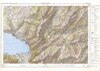
English: 16 map sheets of Siegfriedkarte (scale 1:25,000) used as basis for the sheet #262 of the National Map of Switzerland scale 1:50,000.
Deutsch: Blätter der Siegfriedkarte die als Grundlage für das Skitourenblatt der Landeskarte 1:50'000 dienen: Landeskarte 1:50'000 ein Blatt - Siegfriedkarte 1:25'000 sechzehn Blätter |
|||||||||||||||||||||||||
| Map legend |
Français : Signes conventionnels, Ecritures (1950) |
|||||||||||||||||||||||||
| Source | https://www.swisstopohistoric.ch/text-und-ton/blog/leidgenoessischer-widerstandr-und-die-ersten-skiroutenkarten-151.html | |||||||||||||||||||||||||
| Creator | ||||||||||||||||||||||||||
| Geotemporal data | ||||||||||||||||||||||||||
| Date depicted | ||||||||||||||||||||||||||
| Spatial reference system | projection conforme cylindrique à axe oblique | |||||||||||||||||||||||||
| Scale | 1:50,000 | |||||||||||||||||||||||||
| Heading |
 |
|||||||||||||||||||||||||
| Bibliographic data | ||||||||||||||||||||||||||
| Part of the series | Skiroutenkarten | |||||||||||||||||||||||||
| Map sheet | 262 S (crop) | |||||||||||||||||||||||||
| Language | French | |||||||||||||||||||||||||
| Publisher |
Service topographique fédéral, Wabern-Berne |
|||||||||||||||||||||||||
| Archival data | ||||||||||||||||||||||||||
| Collection |
|
|||||||||||||||||||||||||
| Accession number |
LT LK 262 S 1950 |
|||||||||||||||||||||||||

Licensing[edit]
The data made publicly available by swisstopo may be used, distributed and made accessible. Furthermore, they may be enriched and processed and also used commercially. A reference to the source is mandatory. In the case of digital or analogue representations and publications, as well as in the case of dissemination, one of the following source references must be attached in any case:
Terms of use for free geodata and geoservices (OGD) from swisstopo
|
.svg) |
File history
Click on a date/time to view the file as it appeared at that time.
| Date/Time | Thumbnail | Dimensions | User | Comment | |
|---|---|---|---|---|---|
| current | 19:45, 26 October 2023 |  | 537 × 378 (623 KB) | Enhancing999 (talk | contribs) | Cropped 16 % horizontally, 25 % vertically using CropTool with precise mode. |
| 19:44, 26 October 2023 | 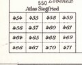 | 641 × 507 (981 KB) | Enhancing999 (talk | contribs) | File:Swisstopo Skiroutenkarte RochersdeNaye LT LK 262 S 1950.tif cropped 96 % horizontally, 96 % vertically using CropTool with precise mode. |
You cannot overwrite this file.
File usage on Commons
The following 2 pages use this file: