File:Karte Venedigergruppe.png
Jump to navigation
Jump to search
Size of this preview: 774 × 600 pixels. Other resolutions: 310 × 240 pixels | 619 × 480 pixels | 991 × 768 pixels | 1,280 × 992 pixels | 2,560 × 1,984 pixels | 5,130 × 3,976 pixels.
Original file (5,130 × 3,976 pixels, file size: 3.49 MB, MIME type: image/png)
Captions
Captions
Add a one-line explanation of what this file represents
Summary[edit]
| Description |
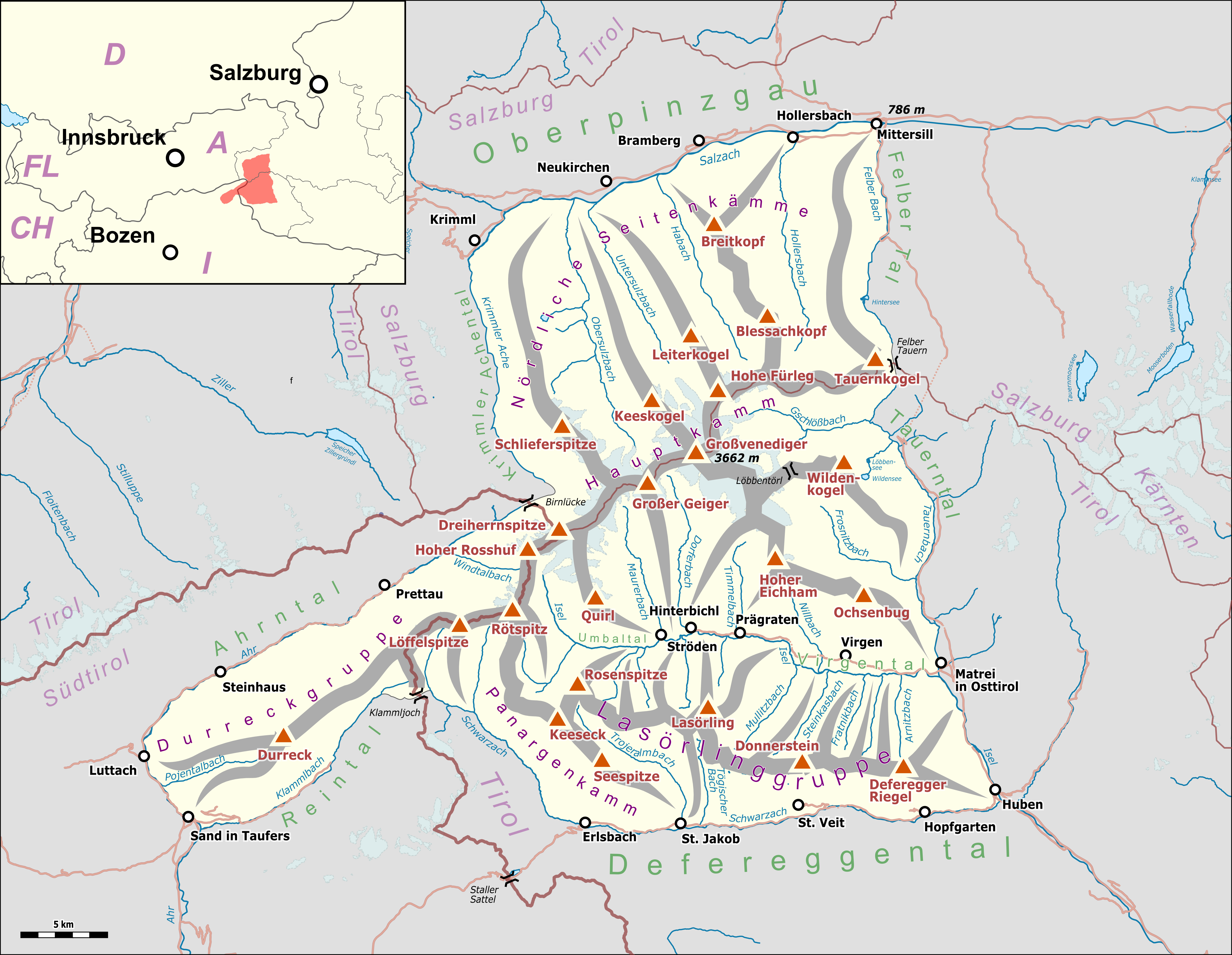
Deutsch: Übersichtskarte der Venedigergruppe. |
|||||||||
| Date | ||||||||||
| Source |
Map was created using:
|
|||||||||
| Creator |
|
|||||||||
| Permission (Reusing this file) |
Map data (c) OpenStreetMap (and) contributors, CC-BY-SA | |||||||||
| Geotemporal data | ||||||||||
| Bounding box |
|
|||||||||
| Georeferencing | ||||||||||
| This work is licensed under the Open Database License (summary). |
File history
Click on a date/time to view the file as it appeared at that time.
| Date/Time | Thumbnail | Dimensions | User | Comment | |
|---|---|---|---|---|---|
| current | 10:50, 14 July 2018 | | 5,130 × 3,976 (3.49 MB) | Pechristener (talk | contribs) | nachgebessert |
| 19:42, 13 July 2018 |  | 5,130 × 3,976 (3.49 MB) | Pechristener (talk | contribs) | location map added | |
| 18:36, 13 July 2018 |  | 5,130 × 3,976 (3.37 MB) | Pechristener (talk | contribs) | == {{int:filedesc}} == {{Map |Description={{de|1=Übersichtskarte der {{w|Venedigergruppe||de}}. }} |Source = Map was created using: *[http://www.openstreetmap.org/ Open Street Map] Data *{{w|Austria location map.svg}} for location map |Author = *Hauptkarte: Pechristener *{{w|Austria location map.svg}} : NordNordWest, {{u|Lencer}} |Date =2017-07-13 |Permission =Map data (c) OpenStreetMap (and) contributors, CC-BY-SA... |
You cannot overwrite this file.
File usage on Commons
The following 4 pages use this file:
File usage on other wikis
The following other wikis use this file:
- Usage on arz.wikipedia.org
- Usage on bg.wikipedia.org
- Usage on de.wikipedia.org
- Habachtal
- Neue Prager Hütte
- Sajathütte
- Essener-Rostocker Hütte
- Kreuzspitze (Venedigergruppe)
- Schernerskopf
- Venedigergruppe
- Alte Prager Hütte
- Bonn-Matreier Hütte
- Nilljochhütte
- Lasörlinggruppe
- Liste der Gebirgsgruppen in den Ostalpen (nach AVE)
- St. Pöltner Hütte
- Eisseehütte
- Panargenkamm
- Lenkjöchlhütte
- Zupalseehütte
- Wunspitze
- Kuhhaut (Venedigergruppe)
- Türml
- Arventalspitze
- Vorlage:Positionskarte Venedigergruppe
- Benutzer Diskussion:Pechristener/Alpenkarten
- Mutti (Gratturm)
- Diskussion:Mutti (Gratturm)
- Gottschaunalm
- Liste der Dreitausender in Salzburg
- Seespitzhütte
- Benutzer:Geiserich77/Wikidata Lienz
- Usage on hy.wikipedia.org
- Usage on it.wikipedia.org
- Usage on www.wikidata.org