File:Kalmarunionen.png
Jump to navigation
Jump to search
No higher resolution available.
Kalmarunionen.png (540 × 238 pixels, file size: 70 KB, MIME type: image/png)
Captions
Captions
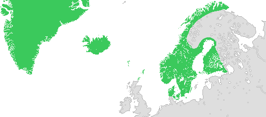
Map of the Kalmar union in 1397

|
This historical map image could be re-created using vector graphics as an SVG file. This has several advantages; see Commons:Media for cleanup for more information. If an SVG form of this image is available, please upload it and afterwards replace this template with
{{vector version available|new image name}}.
It is recommended to name the SVG file “Kalmarunionen.svg”—then the template Vector version available (or Vva) does not need the new image name parameter. |
Summary[edit]
English: Map of the Kalmar union in 1397.
Changes made on 12 July 2012:
- More natural features, such as lakes.
- The southern border of Denmark has been moved northward (the duchies of Schleswig and Holstein weren't made a part of Denmark until 1460).
- The island of Gotland has been removed from the union (in 1396 it came into the hands of pirates and in 1398 it was taken over by the Teutonic Order, who didn't return it to the union until 1408).
- The northern borders of Sweden and Norway have been smoothed out (they were uncertain at this time and weren't drawn according to today's borders until the 17th and 18th centuries).
Svenska: Karta över Kalmarunionen 1397.
Ändringar gjorda 12 juli 2012:
- Fler geografiska delar, såsom sjöar.
- Danmarks sydgräns har flyttats norrut (hertigdömena Schleswig och Holstein blev inte delar av Danmark förrän 1460).
- Gotland har tagits bort från unionen (1396 hamnade ön i händerna på sjörövare och 1398 övertogs den av Tyska orden, som inte återlämnade den till unionen förrän 1408).
- Sveriges och Norges nordgränser har blivit utslätade (de var vid denna tid osäkra och drogs inte enligt nutida gränser förrän under 1600- och 1700-talen).
Licensing[edit]
I, the copyright holder of this work, hereby publish it under the following licenses:

|
Permission is granted to copy, distribute and/or modify this document under the terms of the GNU Free Documentation License, Version 1.2 or any later version published by the Free Software Foundation; with no Invariant Sections, no Front-Cover Texts, and no Back-Cover Texts. A copy of the license is included in the section entitled GNU Free Documentation License. |
| This file is licensed under the Creative Commons Attribution-Share Alike 3.0 Unported license. | ||
| ||
| This licensing tag was added to this file as part of the GFDL licensing update. |
This file is licensed under the Creative Commons Attribution-Share Alike 2.5 Generic, 2.0 Generic and 1.0 Generic license.
- You are free:
- to share – to copy, distribute and transmit the work
- to remix – to adapt the work
- Under the following conditions:
- attribution – You must give appropriate credit, provide a link to the license, and indicate if changes were made. You may do so in any reasonable manner, but not in any way that suggests the licensor endorses you or your use.
- share alike – If you remix, transform, or build upon the material, you must distribute your contributions under the same or compatible license as the original.
You may select the license of your choice.
File history
Click on a date/time to view the file as it appeared at that time.
| Date/Time | Thumbnail | Dimensions | User | Comment | |
|---|---|---|---|---|---|
| current | 10:37, 12 July 2012 | | 540 × 238 (70 KB) | Ludde23 (talk | contribs) | Apparantly, that minor coastline fix wasn't fixed the last time, but now it is. |
| 10:33, 12 July 2012 |  | 540 × 238 (70 KB) | Ludde23 (talk | contribs) | Minor coastline fix. | |
| 10:16, 12 July 2012 |  | 540 × 238 (70 KB) | Ludde23 (talk | contribs) | A more accurate version of the map including: * More natural features, such as lakes. * The southern border of Denmark moved northward (the duchies of Schleswig and Holstein weren't made a part of Denmark until 1460). * The island of Gotland being r... | |
| 15:19, 9 April 2006 |  | 540 × 238 (8 KB) | Masae~commonswiki (talk | contribs) | The Kalmar Union in 1397 in green. |
You cannot overwrite this file.
File usage on Commons
The following page uses this file:
File usage on other wikis
The following other wikis use this file:
- Usage on ast.wikipedia.org
- Usage on bn.wikipedia.org
- Usage on ca.wikipedia.org
- Usage on da.wikipedia.org
- Usage on el.wikipedia.org
- Usage on en.wikipedia.org
- Usage on eo.wikipedia.org
- Usage on es.wikipedia.org
- Usage on eu.wikipedia.org
- Usage on fo.wikipedia.org
- Usage on hr.wikipedia.org
- Usage on la.wikipedia.org
- Usage on nn.wikipedia.org
- Usage on no.wikipedia.org
- Usage on pl.wikipedia.org
- Usage on sv.wikipedia.org
- Usage on zh.wikipedia.org