File:Italija 1810 Slovenscina.png
Jump to navigation
Jump to search

Size of this preview: 413 × 599 pixels. Other resolutions: 165 × 240 pixels | 628 × 911 pixels.
Original file (628 × 911 pixels, file size: 171 KB, MIME type: image/png)
Captions
Captions
Add a one-line explanation of what this file represents

Summary[edit]
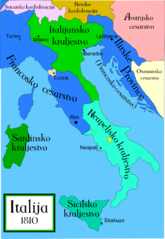
A political map of Italy in 1810, with Slovenian labels. An English version of this map can be found at Image:Italy c 1810.png. The original SVG version of this map, suitable for editting, can be found at Image:Italija 1810 Slovenscina.svg, but it shows a black square that I cannot seem to fix.
A companion map can be found at Image:Italy 1796.png
Licensing[edit]
I, the copyright holder of this work, hereby publish it under the following license:

|
Permission is granted to copy, distribute and/or modify this document under the terms of the GNU Free Documentation License, Version 1.2 or any later version published by the Free Software Foundation; with no Invariant Sections, no Front-Cover Texts, and no Back-Cover Texts. A copy of the license is included in the section entitled GNU Free Documentation License. |
| This file is licensed under the Creative Commons Attribution-Share Alike 3.0 Unported license. | ||
| ||
| This licensing tag was added to this file as part of the GFDL licensing update. |
File history
Click on a date/time to view the file as it appeared at that time.
| Date/Time | Thumbnail | Dimensions | User | Comment | |
|---|---|---|---|---|---|
| current | 03:44, 27 October 2006 | | 628 × 911 (171 KB) | MapMaster (talk | contribs) | I made a few changes based on recommendations from Slovenian editors. |
| 04:11, 20 October 2006 |  | 621 × 901 (166 KB) | MapMaster (talk | contribs) | A political map of Italy in 1810, with Slovenian labels. An English version of this map can be found at Image:Italy c 1810.png. The original SVG version of this map, suitable for editting, can be found at Image:Italija 1810 Slovenscina.svg, bu |
You cannot overwrite this file.
File usage on Commons
There are no pages that use this file.
File usage on other wikis
The following other wikis use this file:
- Usage on sh.wikipedia.org
- Usage on sl.wikipedia.org