File:Islam in Netherlands.jpg
Jump to navigation
Jump to search
Size of this preview: 515 × 599 pixels. Other resolutions: 206 × 240 pixels | 412 × 480 pixels | 660 × 768 pixels | 1,027 × 1,195 pixels.
Original file (1,027 × 1,195 pixels, file size: 264 KB, MIME type: image/jpeg)
Captions
Captions
Add a one-line explanation of what this file represents
| Description |
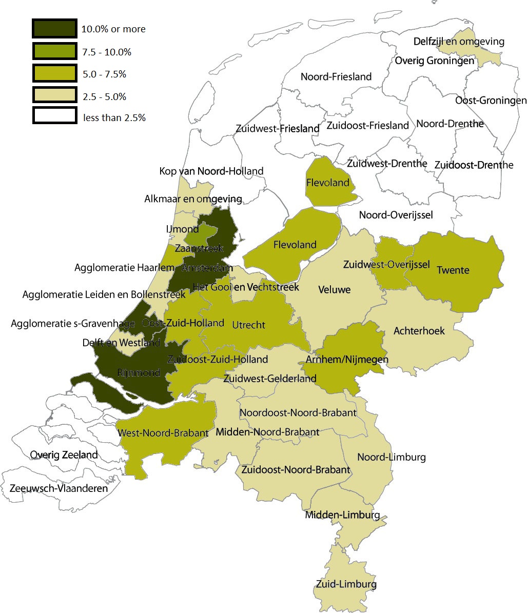
English: Share of Muslims per COROP area, 1 January 2004 . Data are from Statistics Netherlands (this Statline table); note that Statistics Netherlands calculated the number of muslims by adding up all persons by country of 'origin'. That method changed in 2006, allowing for a more accurate measuring of actual muslims; see this CBS webpage. |
| Date | (UTC) |
| Source | |
| Author |
|
| This is a retouched picture, which means that it has been digitally altered from its original version. Modifications: Share of Muslims per COROP area, 1 January 2004. The original can be viewed here: Coropgebieden plain.png:
|
I, the copyright holder of this work, hereby publish it under the following license:
| This file is made available under the Creative Commons CC0 1.0 Universal Public Domain Dedication. | |
| The person who associated a work with this deed has dedicated the work to the public domain by waiving all of their rights to the work worldwide under copyright law, including all related and neighboring rights, to the extent allowed by law. You can copy, modify, distribute and perform the work, even for commercial purposes, all without asking permission.
|
Original upload log[edit]
This image is a derivative work of the following images:
- File:Coropgebieden_plain.png licensed with Cc-zero
- 2010-07-28T16:31:25Z Classical geographer 1027x1195 (213857 Bytes) Without border.
- 2010-07-28T16:30:11Z Classical geographer 1102x1300 (215966 Bytes) B&W and with more readable labels.
- 2009-07-09T11:31:36Z Classical geographer 1199x1407 (554327 Bytes) [[Category:Maps of the Netherlands]] [[Category:Statistical divisions]]
- 2009-07-09T11:30:29Z Classical geographer 3588x3529 (566115 Bytes) {{Information |Description={{en|1=Map of the Dutch NUTS3 regions (COROP regions). Made using GIS software.}} |Source=Own work by uploader |Author=[[User:Classical geographer|Classical geographer]] |Date=2009-07-09 |Permission
Uploaded with derivativeFX
File history
Click on a date/time to view the file as it appeared at that time.
| Date/Time | Thumbnail | Dimensions | User | Comment | |
|---|---|---|---|---|---|
| current | 05:05, 6 January 2011 | | 1,027 × 1,195 (264 KB) | Giornorosso (talk | contribs) | {{Information |Description={{en|1=Map of the Dutch NUTS3 regions (COROP regions). Made using GIS software.}} |Source=*File:Coropgebieden_plain.png |Date=2011-01-06 05:02 (UTC) |Author=*File:Coropgebieden_plain.png: [[User:Classical geographer| |
You cannot overwrite this file.
File usage on Commons
There are no pages that use this file.
File usage on other wikis
The following other wikis use this file:
- Usage on ar.wikipedia.org
- Usage on bn.wikipedia.org
- Usage on fr.wikipedia.org
- Usage on tt.wikipedia.org