File:Iraqi Civil War map (2014–present).png
Jump to navigation
Jump to search

Size of this preview: 586 × 599 pixels. Other resolutions: 235 × 240 pixels | 469 × 480 pixels | 751 × 768 pixels | 1,001 × 1,024 pixels | 2,003 × 2,048 pixels | 3,360 × 3,436 pixels.
Original file (3,360 × 3,436 pixels, file size: 821 KB, MIME type: image/png)
Captions
Captions
Add a one-line explanation of what this file represents
See also : Category:Conflicts by country
Summary

|
This file may be updated to reflect new information. If you wish to use a specific version of the file without new updates being mirrored, please upload the required version as a separate file. |
| Description |
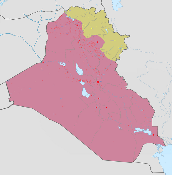
Català: Mapa de la guerra d'Iraq Controlat pel govern
Controlat per l'IS Controlat pels kurds Deutsch: Karte des Bürgerkrieges im Irak.
Kontrolliert von der Irakischen Regierung Kontrolliert vom Islamischen Staat (IS, Daesch, ISIS, ISIL) Kontrolliert durch die irakischen Kurden English: Map of the Second Iraqi War. After updating this map, please also update the date(s) at w:Module:Iraq Syria map date, used to denote the date in articles.
Controlled by the Iraqi Government Controlled by ISIS Controlled by Peshmerga (Kurdistan Regional Government) and other Kurdish forces from the Kurdistan Region Español: Mapa de la guerra of the insurgencia iraquí.
Controlado por el gobierno iraquí. Controlado por el Estado Islámico de Irak y el Levante Controlado por el Peshmerga Français : Carte actualisée de l'actuelle guerre d'Irak. Русский: Карта Гражданской войны в Ираке
Контролируется иракским правительством Контролируется Исламским государством (ИГ, ИГИЛ) Контролируется иракскими курдами |
||||
| Date | |||||
| Source |
Own work |
||||
| Author | Absalao777 | ||||
| Other versions |
|


.png)


.svg)


.svg)

.svg)


_Territory_Change_2014-2016.gif)

_(within_Northern_Syria).svg)


.png)
.svg)


_map.png)
.svg)


.svg)


|
File:Iraqi Civil War map (2014–present).svg is a vector version of this file. It should be used in place of this PNG file when not inferior.
File:Iraqi Civil War map (2014–present).png → File:Iraqi Civil War map (2014–present).svg
For more information, see Help:SVG. |
.svg) |
Licensing
I, the copyright holder of this work, hereby publish it under the following license:
This file is licensed under the Creative Commons Attribution-Share Alike 3.0 Unported license.
- You are free:
- to share – to copy, distribute and transmit the work
- to remix – to adapt the work
- Under the following conditions:
- attribution – You must give appropriate credit, provide a link to the license, and indicate if changes were made. You may do so in any reasonable manner, but not in any way that suggests the licensor endorses you or your use.
- share alike – If you remix, transform, or build upon the material, you must distribute your contributions under the same or compatible license as the original.
File history
Click on a date/time to view the file as it appeared at that time.
.png&dir=prev)
.png&offset=20171201014044)
.png&offset=&limit=20)
.png&offset=&limit=50)
.png&offset=&limit=100)
.png&offset=&limit=250)
.png&offset=&limit=500)
| Date/Time | Thumbnail | Dimensions | User | Comment | |
|---|---|---|---|---|---|
| current | 19:12, 17 March 2019 | | 3,360 × 3,436 (821 KB) | Enterlousy (talk | contribs) | Slightly fixed Iraq. |
| 04:53, 7 March 2019 |  | 3,360 × 3,436 (1.07 MB) | LightandDark2000 (talk | contribs) | With all due respect, the PKK handed over the Sinjar region to the Iraqi Government back in March 2018. See https://en.wikipedia.org/w/index.php?title=Module:Iraqi_insurgency_detailed_map&diff=832661725&oldid=822528600 | |
| 19:23, 24 February 2019 |  | 3,360 × 3,436 (1.07 MB) | Jim7049 (talk | contribs) | Reverted to version as of 02:08, 23 February 2019 (UTC) Reverting vandalism and edit warring, warned the user on their talk page. | |
| 15:06, 24 February 2019 |  | 3,360 × 3,436 (1.07 MB) | AVRTM2 (talk | contribs) | Reverted to version as of 12:53, 3 May 2018 (UTC) | |
| 02:08, 23 February 2019 |  | 3,360 × 3,436 (1.07 MB) | Jim7049 (talk | contribs) | Reverted to version as of 22:36, 21 January 2018 (UTC) PKK never stopped controlling Sinjar, if you believe they did please present a source. | |
| 12:53, 3 May 2018 |  | 3,360 × 3,436 (1.07 MB) | Nate Hooper (talk | contribs) | The PKK no longer controls the Sinjar area. | |
| 22:36, 21 January 2018 |  | 3,360 × 3,436 (1.07 MB) | Rob984 (talk | contribs) | Kifri is under KRG control still. Kurdish media reported an agreement was made with Iraq; and in late December TheNewArab reported that protestors stormed Barzani's KDP offices in the town, pretty much confirming it's still KRG. | |
| 01:02, 12 December 2017 |  | 3,360 × 3,436 (967 KB) | BlueHypercane761 (talk | contribs) | 12-11-2017 Update. ISIL has lost the war in Iraq. I will correct the remaining front lines and coloring issues in about 2-3 weeks. | |
| 17:39, 3 December 2017 |  | 3,360 × 3,436 (996 KB) | Mehrdad 12 (talk | contribs) | Reverted to version as of 22:00, 17 November 2017 (UTC) | |
| 01:40, 1 December 2017 |  | 3,360 × 3,436 (1.07 MB) | Koxem918 (talk | contribs) | Update per request by User:MonsterHunter32. |
You cannot overwrite this file.
File usage on Commons
More than 100 pages use this file. The following list shows the first 100 pages that use this file only. A full list is available.
.png)
- User:Hermes79
- User:Hermes7979
- User:Magog the Ogre/Maps of conflicts/2015 April
- User:Magog the Ogre/Maps of conflicts/2015 August
- User:Magog the Ogre/Maps of conflicts/2015 December
- User:Magog the Ogre/Maps of conflicts/2015 February
- User:Magog the Ogre/Maps of conflicts/2015 January
- User:Magog the Ogre/Maps of conflicts/2015 July
- User:Magog the Ogre/Maps of conflicts/2015 June
- User:Magog the Ogre/Maps of conflicts/2015 March
- User:Magog the Ogre/Maps of conflicts/2015 May
- User:Magog the Ogre/Maps of conflicts/2015 November
- User:Magog the Ogre/Maps of conflicts/2015 October
- User:Magog the Ogre/Maps of conflicts/2015 September
- User:Magog the Ogre/Maps of conflicts/2016 April
- User:Magog the Ogre/Maps of conflicts/2016 February
- User:Magog the Ogre/Maps of conflicts/2016 January
- User:Magog the Ogre/Maps of conflicts/2016 March
- File:2013 Hama Offensive.svg
- File:2015 Latakia Frontlines.svg
- File:Aleppo Offensives 2015.svg
- File:Battle of Daraa City.svg
- File:Battle of Hasakah.svg
- File:Battle of Qamishli.svg
- File:Battle of Raqqa.svg
- File:Battle of Tadmur.svg
- File:Battle of Western Qalamoun.svg
- File:Battlefields in The Global War on Terror.svg
- File:Battlefields in The Global War on Terror - edit03.png
- File:Battlefields in The Global War on Terror - edit04.png
- File:Boko Haram insurgency map.svg
- File:Countries by soldier count.svg
- File:Deir ez-Zor clashes (2017).svg
- File:East Congo conflict map.svg
- File:GSPC map.png
- File:Iraq war map.png (file redirect)
- File:Iraqi Civil War map (2014–present).png
- File:Islamist insurgency in Nigeria.svg
- File:Lebanese insurgency.png
- File:Lebanese insurgency.svg
- File:Libyan Civil War.svg
- File:Libyan war final-fr.svg
- File:Map of Ongoing conflicts around the world.png
- File:Map of terror of the Islamic State (ad-Daula al-islāmiyya).png
- File:Mexico states map small war.PNG
- File:Mosul offensive (2015) map.png
- File:Number of Terrorist Incidents.png
- File:Ongoing Conflicts (1).png
- File:Ongoing conflicts around the world.svg
- File:Pakistan-Waziristan-Map.png
- File:Political map Afar triangle.png
- File:Rif Damashq.svg
- File:Siege of Homs Map.svg
- File:Sinai insurgency.svg
- File:Somali Civil War (2009-present).svg
- File:Southern Sudan Civil War.svg
- File:Sudanese Internal Conflict.svg
- File:Syria and Iraq 2014-onward War map.png
- File:Syrian, Iraqi, and Lebanese insurgencies.png
- File:Syrian civil war.png
- File:Tadmur offensive (2015).jpg
- File:Turkish-PKK rebellion.svg
- File:War in North-West Pakistan.svg
- File:World2s.png
- File:Yemeni Civil War.svg
- File:Саудовско-йеменский конфликт.png
- Template:Ongoing civil wars (maps)
- Category:2015 military intervention in Yemen
- Category:Attack
- Category:Battle of Aleppo
- Category:Battles of Syria
- Category:Battles of the Syrian Civil War
- Category:Civil wars
- Category:Conflicts
- Category:Conflicts by continent
- Category:Conflicts by country
- Category:Conflicts by type
- Category:Current civil wars maps
- Category:Feuds
- Category:Fights
- Category:Maps of Somali Civil War
- Category:Maps of conflicts
- Category:Maps of disputed territories
- Category:Maps of the 2014 pro-Russian unrest in Ukraine
- Category:Maps of the Demilitarized Zone of Korea
- Category:Maps of the War in Afghanistan (2001–2021)
- Category:Maps of wars
- Category:Military conflicts
- Category:Military maps of the world
- Category:Ongoing armed conflicts
- Category:Quarrels
- Category:Rebellions
- Category:Riots
- Category:Schisms
- Category:Syrian Civil War
- Category:Terrorism
- Category:Uprisings
- Category:War
- Category:War casualties
- Category:Warfare by type
.png)
.png)
.jpg)
View more links to this file.
File usage on other wikis
The following other wikis use this file:
- Usage on ar.wikipedia.org
- Usage on ast.wikipedia.org
- Usage on ca.wikipedia.org
- Usage on ckb.wikipedia.org
- Usage on cs.wikipedia.org
- Usage on da.wikipedia.org
- Usage on el.wikipedia.org
- Usage on en.wikipedia.org
- Usage on es.wikipedia.org
- Usage on et.wikipedia.org
- Usage on eu.wikipedia.org
- Usage on fa.wikipedia.org
- Usage on fr.wikipedia.org
- Usage on gl.wikipedia.org
- Usage on he.wikipedia.org
- Usage on hu.wikipedia.org
- Usage on hy.wikipedia.org
- Usage on it.wikipedia.org
- Usage on ka.wikipedia.org
- Usage on ko.wikipedia.org
- Usage on lv.wikipedia.org
- Usage on mk.wikipedia.org
- Usage on mt.wikipedia.org
- Usage on nn.wikipedia.org
- Usage on pl.wikipedia.org
- Usage on pnb.wikipedia.org
- Usage on pt.wikipedia.org
- Usage on ro.wikipedia.org
View more global usage of this file.
.png)
.png&oldid=827732958)