File:Illustrated Atlas of Shanhai, Yongping, Jizhou, Miyun, Gubeikou, Huanghua Zhen and Other Areas WDL11386.pdf
Jump to navigation
Jump to search

Size of this JPG preview of this PDF file: 231 × 599 pixels. Other resolutions: 92 × 240 pixels | 185 × 480 pixels | 296 × 768 pixels | 395 × 1,024 pixels | 1,447 × 3,750 pixels.

Original file (1,447 × 3,750 pixels, file size: 6.19 MB, MIME type: application/pdf, 71 pages)
Captions
Captions
Add a one-line explanation of what this file represents
Summary[edit]
| Title |
Русский: Иллюстрированный атлас Шанхая, Юнпина, Цзичжоу, Миюня, Губэйкоу, Хуанхуа Чжэнь и других областей
Français : Atlas illustré de Shanhai, Yongping, Jizhou, Miyun, Gubeikou, Huanghua Zhen et d'autres régions
English: Illustrated Atlas of Shanhai, Yongping, Jizhou, Miyun, Gubeikou, Huanghua Zhen and Other Areas
中文:山海永平薊州密云古北口黄花镇等处地方里路图本
Português: Atlas ilustrado de Shanhai, Yongping, Jizhou, Miyun, Gubeikou, Huanghua Zhen e outras áreas
العربية: أطلس توضيحي لشانهاي ويونغ بينغ وجي جو ومي يوَن وجو باي كو وهوانغ هوا جين ومناطق أخرى
Español: Atlas ilustrado de Shanhai, Yongping, Jizhou, Miyun, Gubeikou, Huanghua Zhen y otras áreas |
| Description |
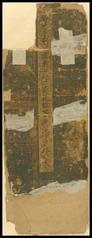
Русский: Эта работа представляет собой иллюстрированную военную карту северо-восточной части Цзинши (современный Пекин) вдоль Великой стены и датируется периодом правления династии Мин (1368–1644 гг.). Листы карты (58,8 сантиметра в высоту и 21 сантиметр в ширину) сложены "гармошкой". Края атласа обломаны и потерты. Первый коллекционер с большой осторожностью прикрепил атлас к твердой доске и поместил в футляр. На карте изображен Шаньхайгуань (Шанхайский проход), начинающийся у Бохайского залива на востоке, извивающийся в направлении на запад через Фунин Сянь, Чанли Сянь, Лэтин Сянь, Юнпин Фу, Луаньчжоу, Цяньань Сянь, Сифэнко, Ловэньгу, Цзуньхуа Сянь, Юйтянь Сянь, Маланьгу Гуань, Цзичжоу, Пингу Сянь, Цзицзячжуан Ин, Сыматай Ин, Губэйкоу Ин, Чаохэчжай (посты один–семь), Баймагуань, Шитанлин Ин, Миюнь Сянь, Шуньи Сянь, Хуайжоу Сянь, Бахайсо, Хуанхуа Чжэнь и, наконец, проходящий от Люйаньлина (горы Ослиное седло) до входа в Дачжэньгу (Великую ореховую долину). Карта заканчивается в Нанье. Остальная часть атласа отсутствует. Непрерывные горы и холмы окрашены зеленым, и их направления четко показаны на карте. Единственный недостаток атласа заключается в отсутствии названий рек, поэтому неясно, какие реки на нем изображены. Великая стена представлена как непрерывная белая полоса, проходящая через горы и холмы, с сотнями рвов и военных постов. Красные бумажные ленты, на которых указаны расстояния до определенного поста или прохода, прикреплены под постами, обозначенными белым цветом. Эти названия на других картах, как правило, не указаны. До наших дней дошло очень мало военных атласов времен династии Мин, что придает особую ценность этому редкому, частично сохранившемуся сокровищу.
Историческая география; Рукописные карты; Военные карты; Названия, географические — Китай Français : Cet ouvrage est une carte militaire illustrée, réalisée sous la dynastie Ming (1368–1644), représentant le nord-est de Jingshi (aujourd'hui Pékin) et la Grande Muraille. Il est formé de feuilles pliées en accordéon, de grand format, et mesure 58,8 centimètres de haut et 21 centimètres de large. Les bords de l'atlas sont endommagés et déchirés. Le premier collectionneur de l'atlas en prit grand soin, et l'attacha à un panneau rigide pour le ranger dans un coffret. La carte représente Shanhaiguan (col de Shanhai) de la mer de Bohai à l'est, se déroulant vers l'ouest à travers le xian de Funing, le xian de Changli, le xian de Leting, Yongping Fu, Luanzhou, le xian de Qian'an, Xifengkou, Luowengu, le xian de Zunhua, le xian d'Yutian, Malangu Guan, Jizhou, le xian de Pinggu, Jijiazhuang Ying, Simatai Ying, Gubeikou Ying, Chaohezhai (premier des sept avant-postes), Baimaguan, Shitangling Ying, le xian de Miyun, le xian de Shunyi, le xian d'Huairou, Bohaisuo, Huanghua Zhen, et enfin Lü'anling (montagne de la selle d'âne), à l'entrée de Dazhengu (grande vallée des noisettes). Cette carte s'arrête à Nanye. Le reste de l'atlas a disparu. Les collines et les montagnes ininterrompues sont peintes en vert et représentées clairement avec leur orientation. L'inconvénient de cet atlas est qu'il ne fournit pas le nom des rivières, ne permettant pas de les identifier avec certitude. La Grande Muraille ondule constamment à travers les montagnes et les collines, avec des centaines de douves et de postes militaires peints en blanc. Des morceaux de papier rouges indiquant les distances vers un poste ou un col donné sont collés au-dessous des postes blancs. Habituellement, ces noms n'apparaissent pas sur les autres cartes. Aujourd'hui, il existe très peu d'atlas militaires datant de la dynastie Ming, ce qui confère une grande valeur à cet ouvrage parcellaire.
Géographie historique; Cartes manuscrites; Cartes militaires; Noms géographiques - Chine English: This work is an illustrated military map dating from the Ming dynasty (1368–1644) of the northeastern part of Jingshi (present-day Beijing), along the Great Wall. It is formatted in accordion pleat-like leaves, and is large, measuring 58.8 centimeters high by 21 centimeters wide. The edges of the atlas are broken and frayed. The original collector tied the atlas on a hard board and placed it in a case, taking great care. The map depicts Shanhaiguan (Shanhai Pass) from Bohai Sea in the east, winding westward through Funing Xian, Changli Xian, Leting Xian, Yongping Fu, Luanzhou, Qian’an Xian, Xifengkou, Luowengu, Zunhua Xian, Yutian Xian, Malangu Guan, Jizhou, Pinggu Xian, Jijiazhuang Ying, Simatai Ying, Gubeikou Ying, Chaohezhai (outposts one to seven), Baimaguan, Shitangling Ying, Miyun Xian, Shunyi Xian, Huairou Xian, Bohaisuo, Huanghua Zhen, and lastly from Lü’anling (Donkey Saddle Mountains) to the entrance of Dazhengu (Great Hazelnut Valley). This map ends at Nanye. The rest of the atlas is missing. The unbroken mountains and hills are painted green and their directions are depicted clearly. The one drawback of the atlas is that it does not provide names for rivers, so it is uncertain which ones are depicted. The Great Wall is shown snaking continuously through the mountains and hills, with hundreds of moats and military posts, all painted in white. Red-colored paper slips recording the distances to a certain post or pass are taped below the white-colored posts. These names normally are not seen on other maps. Very few military atlases from the Ming dynasty are extant, making this rare fragmentary treasure a work of great value.
Historical geography; Manuscript maps; Military maps; Names, Geographical--China 中文:本书是明代描绘京师(北直隸)东北方的军事地图,乃沿著长城而绘。 此图为经摺装,版式宽大。唯摺口多已断裂成为散张。藏者以硬纸板綑束,外加函套,甚为珍視。全图描述从东起渤海边上的山海关,蜿蜒西行,经抚宁县、昌黎县、乐亭县、永平府、滦州、迁安县、喜峰口、罗文谷、遵化县、玉田县、马兰谷关、薊州、平谷县、吉家庄营、司马台营、古北口营、潮河寨(一至七寨)、白马关、石塘岭营、密云县、顺义县、怀柔县、渤海所、黄花镇,最后自驴鞍岭至大榛谷口,再至南冶口止。其后部分地图缺。沿途所绘綠色山丘,绵延不断,其座落方位,当系实景。唯惜所绘河流均未标注名字,故不详其为何山何水。图中绘有长城蜿蜒于各山丘间,城池营寨数百座,皆以白色涂料涂之。再此,以红纸条记录从某一关至某一寨有若干里,纸条粘贴其下。這些地名皆为一般地图上所不易見得者。明代之军事地图传世甚稀,存此吉光片羽,甚为宝惜。
历史地理学; 手绘地图; 军事地图; 地理名称--中国 Português: Esta obra é um mapa militar ilustrado, datado da dinastia Ming (1368 a 1644), da parte nordeste de Jingshi (atual Pequim), ao longo da Grande Muralha. Ela está formatada em folhas com pregas sanfonadas e é grande, medindo 58,8 centímetros de altura por 21 centímetros de largura. As bordas do atlas estão quebradas e desgastadas. O colecionador original amarrou o atlas em uma placa rígida e o colocou em uma caixa, com grande cuidado. O mapa representa Shanhaiguan (Passo de Shanhai), visto do Mar de Bohai a leste, indo no sentido a oeste por Funing Xian, Changli Xian, Leting Xian, Yongping Fu, Luanzhou, Qian’an Xian, Xifengkou, Luowengu, Zunhua Xian, Yutian Xian, Malangu Guan, Jizhou, Pinggu Xian, Jijiazhuang Ying, Simatai Ying, Gubeikou Ying, Chaohezhai (postos avançados de um a sete), Baimaguan, Shitangling Ying, Miyun Xian, Shunyi Xian, Huairou Xian, Bohaisuo, Huanghua Zhen e, finalmente, de Lü'anling (Montanhas da Sela do Burro) até a entrada de Dazhengu (Grande Vale do Avelã). Este mapa termina em Nanye. O restante do atlas está faltando. As montanhas e colinas contínuas estão pintadas em verde e têm suas direções claramente representadas. A única desvantagem do atlas é que ele não fornece os nomes dos rios e, portanto, não se pode ter certeza de quais estão representados. A Grande Muralha é mostrada serpenteando continuamente através das montanhas e colinas, com centenas de fossos e postos militares, todos pintados em branco. Tiras de papel de cor vermelha registrando as distâncias até certos postos ou passagens estão colados abaixo dos postos de cor branca. Estes nomes normalmente não são vistos em outros mapas. Poucos atlas militares da dinastia Ming ainda existem, o que torna este raro tesouro fragmentado uma obra de grande valor.
Geografia histórica; Mapas manuscritos; Mapas militares; Nomes, geográficos--China العربية: هذا العمل هو خريطة حربية مرسومة للجزء الشمالي الشرقي لجِنْغ شي (بكين الحالية)، على طول السور العظيم، ويرجع تاريخها إلى عهد أسرة مينغ (1368–1644). رُتِبَت الخريطة في أوراق مطوية بثنيات بطريقة تشبه الأكورديون، وهي كبيرة، قياسها بارتفاع 58.8 سنتيمتر وبعرض 21 سنتيمتر. حواف الأطلس مُقطعة ومُتَهَرِّئة. ربط الجامع الأصلي الأطلس على لوحة صلبة ووضعه في حافظة، بحرص شديد. تُصور الخريطة شانهايغوان (معبر شانهاي) من بحر بوهاي بالشرق، ينعطف غربًا عبر فونينغ شيان وتشانغ لي شيان ولاتينغ شيان ويونغ بينغ فو ولوان جو وتشيانان شيان وشي فينغ كو ولو وِن غو وزوَن هوا شيان ويوتيان شيان ومالانغو غوان وجي جو وبينغ غو شيان وجي جيا تشانغ يِنغ وسيماتاي يِنغ وغوبايكو يِنغ وتشاوهيجاي (المعسكرات البعيدة من واحد إلى سبعة) وبايماغوان وشيتانغلينغ يِنغ ومي يوَنْ شيان وبوهايسواو وهوانغ هوا جين وأخيرًا من لو أنلينغ (جبال سرج الحمار) إلى مدخل داتشينغو (وادي البندق العظيم). تنتهي هذه الخريطة في نانيِه. بقية الأطلس مفقودة. طُليَت الجبال والتلال المتواصلة باللون الأخضر ورُسِمَت اتجاهاتها بوضوح. العيب الوحيد الموجود بالأطلس هو أنه ليس به أسماء للأنهار، لذا فإنه من غير الواضح أيّ الأنهار مرسوم. يظهر السور العظيم كأنه يتلوى باستمرار عبر الجبال والتلال، بالإضافة إلى مئات الخنادق المائية والمعسكرات، التي طُليت جميعها باللون الأبيض. أُلصقت القصاصات الورقية حمراء اللون، التي تشير للمسافة إلى معسكر أو معبر معين، أسفل علامات المعسكرات بيضاء اللون. لا تظهر هذه الأسماء عادةً بخرائط أخرى. يوجد عدد قليل جدًا من الأطالِس العسكرية من أسرة مينغ، مما يجعل هذا الكنز المُجزأ النادر عملًا ذا قيمة كبيرة.
الجغرافيا التاريخية; الخرائط المخطوطة; الخرائط الحربية; الأسماء، الجغرافية--الصين Español: Esta obra es un mapa militar ilustrado, que data de la dinastía Ming (1368–1644) y muestra la parte noreste de Jingshi (actual Pekín) a lo largo de la Gran Muralla. El mapa ha sido confeccionado en hojas plegadas en acordeón, y es grande: mide 58,8 centímetros de alto y 21 centímetros de ancho. Los bordes del atlas están rasgados y desgastados. El coleccionista original ató el atlas a una tabla dura y lo guardó cuidadosamente en un estuche. El mapa muestra el serpenteo de Shanhaiguan (el Paso Shanhai), en dirección oeste, desde el mar de Bohai. Atraviesa Funing Xian, Changli Xian, Leting Xian, Yongping Fu, Luanzhou, Qian’an Xian, Xifengkou, Luowengu, Zunhua Xian, Yutian Xian, Malangu Guan, Jizhou, Pinggu Xian, Jijiazhuang Ying, Simatai Ying, Gubeikou Ying, Chaohezhai (puestos uno al siete), Baimaguan, Shitangling Ying, Miyun Xian, Shunyi Xian, Huairou Xian, Bohaisuo, Huanghua Zhen y, finalmente, recorre desde Lü’anling (montañas Silla de Burro) hasta la entrada de Dazhengu (Gran Valle de las Avellanas). Este mapa termina en Nanye. Falta el resto del atlas. Las ininterrumpidas montañas y colinas están pintadas en verde, y sus direcciones se muestran de forma clara. El único inconveniente del atlas es que no proporciona los nombres de los ríos, por lo que no está claro cuáles se muestran. Se aprecia el continuo serpenteo de la Gran Muralla, con cientos de fosas y puestos militares pintados en blanco, a través de las montañas y las colinas. Los trozos de papel de color rojo, que registran las distancias a un puesto o paso, están pegados debajo de los puestos (marcados en blanco). Generalmente estos nombres no se ven en otros mapas. Se conservan muy pocos atlas militares de la dinastía Ming, lo que convierte a este raro tesoro fragmentario en una obra de gran valor.
Geografía histórica; Mapas manuscritos; Mapas militares; Nombres, geográficos - China |
| Date | between 1368 and 1644 |
| Medium |
Русский: Книги
Français : Livres
English: Books
中文:图书
Português: Livros
العربية: كتب
Español: Libros |
| Dimensions |
English: 1 folded volume, 58.8 centimeters |
| Collection |
Русский: Национальная центральная библиотека
Français : Bibliothèque centrale nationale
English: National Central Library
中文:国立中央图书馆
Português: Biblioteca Nacional Central
العربية: المكتبة المركزية الوطنية
Español: Biblioteca Nacional Central |
| Place of creation |
Русский: Китай
Français : Chine
English: China
中文:中国
Português: China
العربية: الصين
Español: China |
| Notes | Original language title: 山海永平薊州密雲古北口黃花鎮等處地方里路圖本 |
| Source/Photographer |
http://dl.wdl.org/11386/service/11386.pdf
|
Licensing[edit]
|
This is a faithful photographic reproduction of a two-dimensional, public domain work of art. The work of art itself is in the public domain for the following reason:
The official position taken by the Wikimedia Foundation is that "faithful reproductions of two-dimensional public domain works of art are public domain".
This photographic reproduction is therefore also considered to be in the public domain in the United States. In other jurisdictions, re-use of this content may be restricted; see Reuse of PD-Art photographs for details. | ||||
File history
Click on a date/time to view the file as it appeared at that time.
| Date/Time | Thumbnail | Dimensions | User | Comment | |
|---|---|---|---|---|---|
| current | 09:33, 1 March 2014 | 1,447 × 3,750, 71 pages (6.19 MB) | Fæ (talk | contribs) | =={{int:filedesc}}== {{Artwork |artist = |author = |title ={{ru|1=Иллюстрированный атлас Шанхая, Юнпина, Цзичжоу, Миюня, Губэйкоу, Хуанхуа Чжэнь и других областей}} {{fr|1=... |
You cannot overwrite this file.
File usage on Commons
The following page uses this file: