File:Iberian Peninsula geological map ES.svg
Jump to navigation
Jump to search

Size of this PNG preview of this SVG file: 556 × 600 pixels. Other resolutions: 222 × 240 pixels | 445 × 480 pixels | 712 × 768 pixels | 949 × 1,024 pixels | 1,899 × 2,048 pixels | 559 × 603 pixels.
Original file (SVG file, nominally 559 × 603 pixels, file size: 3.76 MB)
Captions
Captions
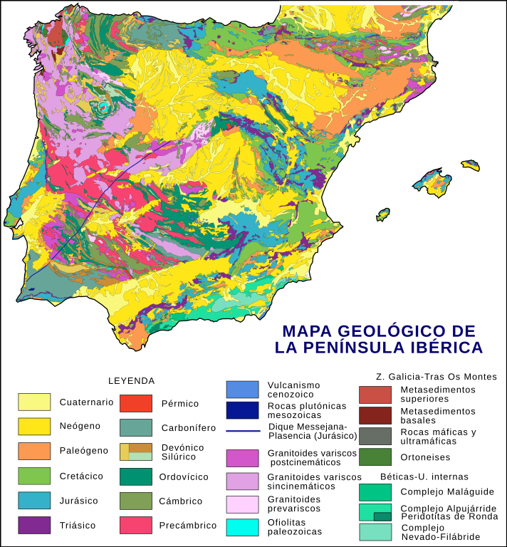
Iberian Peninsula simplified geological map.
Summary[edit]
| Description |
Español: Mapa geológico simplificado de la Península Ibérica. Síntesis basada en la interpretación y simplificación de diferentes fuentes: Gabaldón, V. et al. (1994) Mapa Geológico de la Península Ibérica, Baleares y Canarias. Instituto Tecnológico Geominero de España; Rodríguez Fernández, L. R. et al. (2004) "Mapa geológico de España con la inclusión de Portugal continental y Pirineos franceses. Escala 1:2.000.000" en: Vera, J. A. (ed.) (2004) Geología de España. Sociedad Geológica de España e Instituto Geológico y Minero de España. ISBN 84-7840-546-1 y "Mapa Geológico de España" en: Meléndez Hevia, I. (2004) Geología de España. Una historia de seiscientos millones de años. Rueda. ISBN 84-7207-144-8 y de numerosos esquemas parciales en Vera (op. cit.). Todos los errores cartográficos e imprecisiones debidas a la necesaria simplificación son achacables exclusivamente a este usuario (PePeEfe). La dilatada evolución geológica de la península y lo complejo de las exóticas unidades alóctonas del Macizo Ibérico y de las Béticas han requerido una simplificación excesiva, por lo que este mapa debe ser tomado como una mera aproximación a la geología ibérica. Se recomienda, por tanto, consultar las fuentes originales, y otras más especializadas, para su correcta comprensión. Para las unidades cronoestratigráficas (Silúrico, Jurásico, etc.) se han usado los colores estándares RGB de la escala estratigráfica internacional, el resto son arbitrarios, intentando la correcta visualización. English: Iberian Peninsula simplified geological map. Summary based on the interpretation and simplification of different sources: Gabaldón, V. et al. (1994) Mapa Geológico de la Península Ibérica, Baleares y Canarias. Instituto Tecnológico Geominero de España; Rodríguez Fernández, L. R. et al. (2004) "Mapa geológico de España con la inclusión de Portugal continental y Pirineos franceses. Escala 1:2.000.000" in: Vera, J. A. (ed.) (2004) Geología de España. Sociedad Geológica de España & Instituto Geológico y Minero de España. ISBN 84-7840-546-1 and "Mapa Geológico de España" in: Meléndez Hevia, I. (2004) Geología de España. Una historia de seiscientos millones de años. Rueda. ISBN 84-7207-144-8 and numerous partial schemes from Vera (op. cit.). All cartographic errors and inaccuracies, due to the necessary simplification, are attributable solely to this user (PePeEfe). The long geological evolution of the Iberian Peninsula and the complexity of the exotic allochthonous units of the Iberian Massif and the Baetic Ranges have required an oversimplification, so this map should be taken as an rough approximation to the Iberian Geology. For proper understanding, it is recommended, therefore, consult the original sources, and other more specialized. For chronostratigraphic units (Silurian, Jurassic, etc.) have been used the International Stratigraphic Scale RGB standard colors, others are arbitrary, trying a correct display. |
| Date | |
| Source | Own work |
| Author | PePeEfe |
| Other versions | Derivative works of this file: Iberian Peninsula geological map EN.svg |
Licensing[edit]
I, the copyright holder of this work, hereby publish it under the following license:
This file is licensed under the Creative Commons Attribution-Share Alike 4.0 International license.
- You are free:
- to share – to copy, distribute and transmit the work
- to remix – to adapt the work
- Under the following conditions:
- attribution – You must give appropriate credit, provide a link to the license, and indicate if changes were made. You may do so in any reasonable manner, but not in any way that suggests the licensor endorses you or your use.
- share alike – If you remix, transform, or build upon the material, you must distribute your contributions under the same or compatible license as the original.
This vector image was created with Inkscape .
File history
Click on a date/time to view the file as it appeared at that time.
| Date/Time | Thumbnail | Dimensions | User | Comment | |
|---|---|---|---|---|---|
| current | 20:27, 10 February 2022 | | 559 × 603 (3.76 MB) | PePeEfe (talk | contribs) | my own mistake, the Quaternary is not visible |
| 20:20, 10 February 2022 |  | 559 × 603 (3.76 MB) | PePeEfe (talk | contribs) | Update of the chronostratigraphy (Neogene to Paleogene) of the Cenozoic basins of the NW: El Bierzo, As Pontes, etc. | |
| 14:41, 11 July 2019 |  | 559 × 603 (3.76 MB) | Rowanwindwhistler (talk | contribs) | fake text added, slight change in font to try to improve readability in the articles. | |
| 10:02, 1 February 2015 |  | 542 × 603 (2.91 MB) | PePeEfe (talk | contribs) | User created page with UploadWizard |
You cannot overwrite this file.
File usage on Commons
The following 3 pages use this file:
File usage on other wikis
The following other wikis use this file:
- Usage on ca.wikipedia.org
- Usage on es.wikipedia.org
- Usage on ky.wikipedia.org