File:IPY Antarctica 2012 150.pdf
Jump to navigation
Jump to search

Size of this JPG preview of this PDF file: 600 × 600 pixels. Other resolutions: 240 × 240 pixels | 480 × 480 pixels | 768 × 768 pixels | 1,024 × 1,024 pixels | 2,048 × 2,048 pixels | 4,987 × 4,987 pixels.
Original file (4,987 × 4,987 pixels, file size: 2.8 MB, MIME type: application/pdf)
Captions
Captions
Add a one-line explanation of what this file represents

|
File:IPY Antarctica 2012 150.svg is a vector version of this file. It should be used in place of this PDF file.
File:IPY Antarctica 2012 150.pdf → File:IPY Antarctica 2012 150.svg
For more information, see Help:SVG. |
 |
| Description |
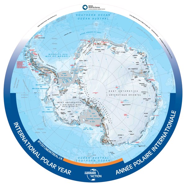
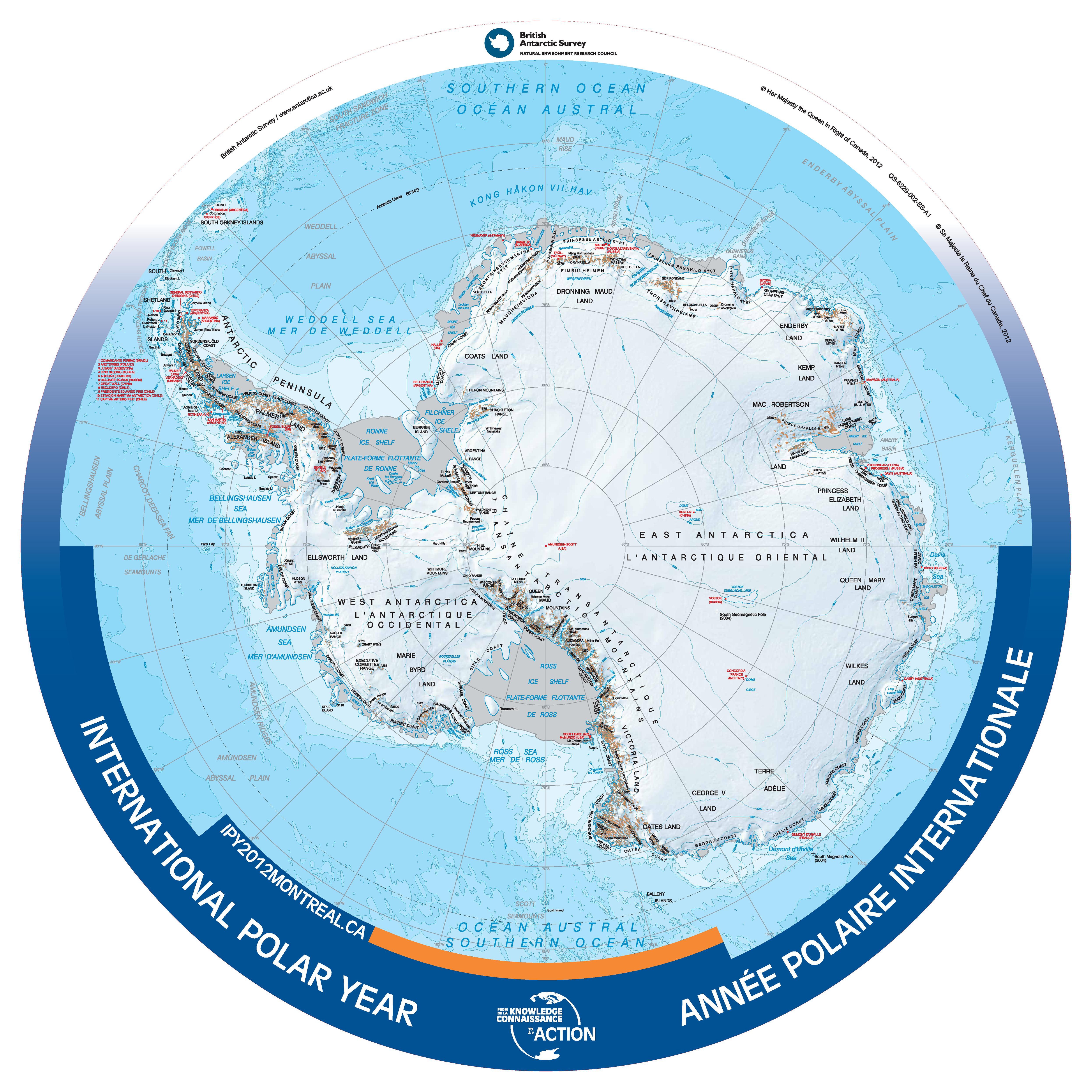
English: Bilingual (French/English) map of Antarctica, produced for the 2012 International Polar Year.
International Polar Year - 2012 - Antarctic Region Contained within the Atlas of Canada's Reference Map Series, 1961 to 2012, is a revised bilingual map which was produced as a special product for the International Polar Year 2012. It was produced from the British Antarctic Survey (2010) Antarctica and the Arctic 1:10 000 000 scale map, Series BAS (Misc) Sheets 15A and 15B. Its round shape shows detail from south of 60 degrees latitude. The map uses the Polar Stereographic projection. All international boundaries are shown. Some seasonally populated places are shown. A number of significant features can be found such as coastline and ice shelves; bathymetry; ice/rock limits; contours, key mountain summits and hill-shaded terrain, and scientific research stations. |
|||||
| Date | ||||||
| Source | Data.gc.ca, http://data.gc.ca/data/en/dataset/952e973e-6ff4-5664-a1cc-8036b2f461fc | |||||
| Author | British Antarctic Survey/Government of Canada | |||||
| Permission (Reusing this file) |
|
.svg)
File history
Click on a date/time to view the file as it appeared at that time.
| Date/Time | Thumbnail | Dimensions | User | Comment | |
|---|---|---|---|---|---|
| current | 21:29, 5 January 2014 |  | 4,987 × 4,987 (2.8 MB) | Oaktree b (talk | contribs) | {{Information |Description ={{en|1=Bilingual (French/English) map of Antarctica, produced for the 2012 International Polar Year.}} |Source =Data.gc.ca, http://data.gc.ca/data/en/dataset/952e973e-6ff4-5664-a1cc-8036b2f461fc |Author =B... |
You cannot overwrite this file.
File usage on Commons
The following page uses this file:
File usage on other wikis
The following other wikis use this file:
- Usage on hy.wikipedia.org