File:Hydrograph of Patapsco River near Elkridge at Patapsco Valley State Park.png
Jump to navigation
Jump to search

No higher resolution available.
Hydrograph_of_Patapsco_River_near_Elkridge_at_Patapsco_Valley_State_Park.png (600 × 465 pixels, file size: 18 KB, MIME type: image/png)
Captions
Captions
Add a one-line explanation of what this file represents
Summary
[edit]
| Description |
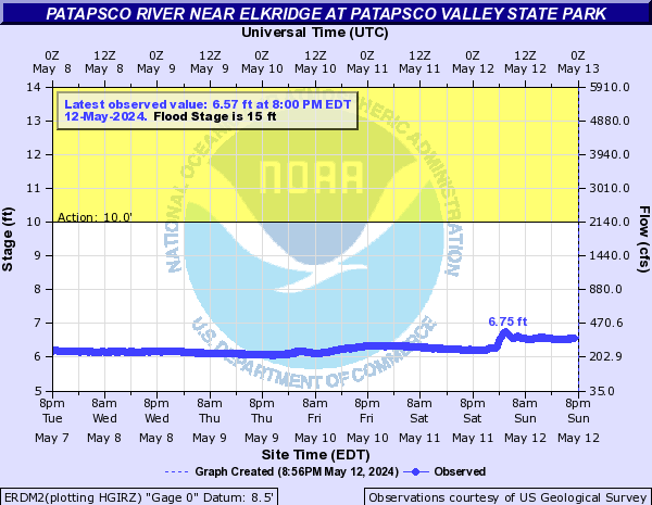
English: Hydrograph of Patapsco River near Elkridge at Patapsco Valley State Park Purple: Major Flood Stage; Red: Moderate Flood Stage; Orange: Minor Flood Stage; Yellow: Action Stage; |
| Date | |
| Source |
Patapsco River near Elkridge at Patapsco Valley State Park archived at the Wayback Machine |
| Author | Advanced Hydrologic Prediction Service, National Weather Service, NOAA |
Licensing
[edit]
This image is in the public domain because it contains materials that originally came from the U.S. National Oceanic and Atmospheric Administration, taken or made as part of an employee's official duties.
|
File history
Click on a date/time to view the file as it appeared at that time.
| Date/Time | Thumbnail | Dimensions | User | Comment | |
|---|---|---|---|---|---|
| current | 06:06, 30 May 2018 | | 600 × 465 (18 KB) | Phoenix7777 (talk | contribs) | User created page with UploadWizard |
You cannot overwrite this file.
File usage on Commons
There are no pages that use this file.
File usage on other wikis
The following other wikis use this file:
- Usage on en.wikipedia.org