File:Harz map.svg
Jump to navigation
Jump to search

Size of this PNG preview of this SVG file: 512 × 303 pixels. Other resolutions: 320 × 189 pixels | 640 × 379 pixels | 1,024 × 606 pixels | 1,280 × 758 pixels | 2,560 × 1,515 pixels.
Original file (SVG file, nominally 512 × 303 pixels, file size: 2.97 MB)
Captions
Captions
Add a one-line explanation of what this file represents

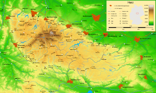
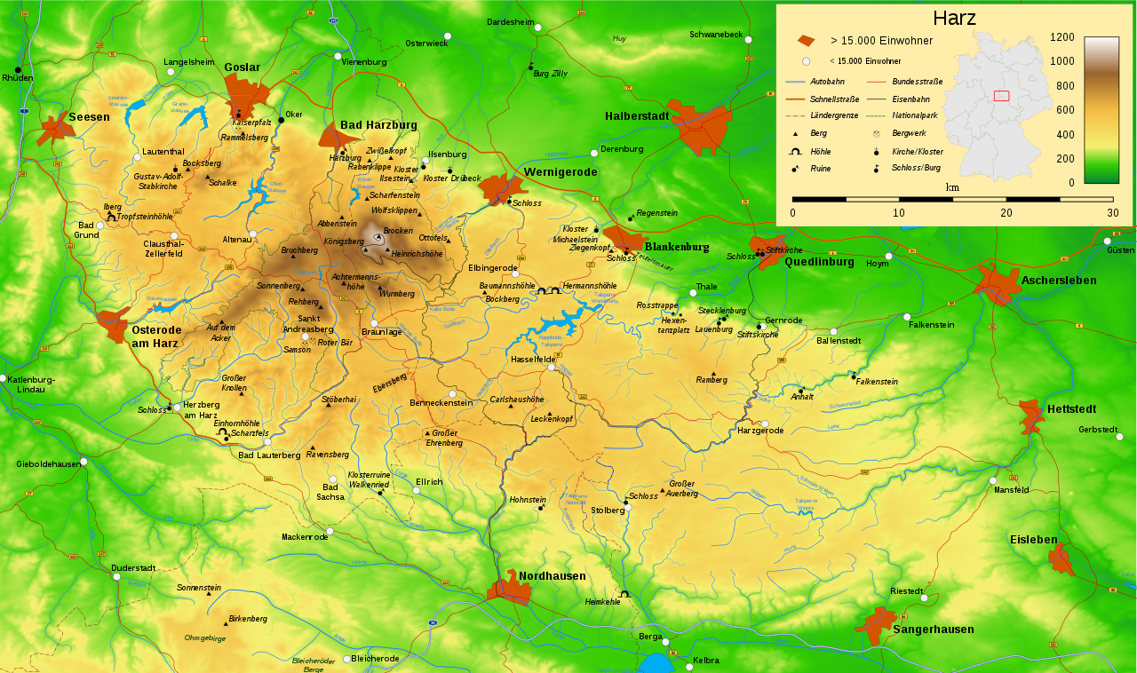
| Description | Map of the Harz mountains in Germany with mountains, rivers, lakes, reservoirs, all highways, all Bundesstraßen, Harzquerbahn, Brockenbahn, Selketalbahn, major towns and sights. svg-version (German) | ||
| Date | |||
| Source | Own work | ||
| Author | Bamse | ||
| Other versions |
 , ,  , , |
||
| SVG development |
|

The map has been created with the Generic Mapping Tools: https://www.generic-mapping-tools.org/ using one or more of these public-domain datasets for the relief:
|

|
Permission is granted to copy, distribute and/or modify this document under the terms of the GNU Free Documentation License, Version 1.2 or any later version published by the Free Software Foundation; with no Invariant Sections, no Front-Cover Texts, and no Back-Cover Texts. A copy of the license is included in the section entitled GNU Free Documentation License. |
| This file is licensed under the Creative Commons Attribution-Share Alike 3.0 Unported license. | ||
| ||
| This licensing tag was added to this file as part of the GFDL licensing update. |

|
This SVG file contains embedded text that can be translated into your language, using any capable SVG editor, text editor or the SVG Translate tool. For more information see: About translating SVG files. |
File history
Click on a date/time to view the file as it appeared at that time.
| Date/Time | Thumbnail | Dimensions | User | Comment | |
|---|---|---|---|---|---|
| current | 21:47, 12 May 2018 | | 512 × 303 (2.97 MB) | JoKalliauer (talk | contribs) | combined both old version, because last one had more text, but in the legend were not working pictures |
| 09:33, 3 October 2011 |  | 10,084 × 5,973 (3.64 MB) | McZusatz (talk | contribs) | Reverted to version as of 15:58, 15 December 2009(this thumbnail seems to work as well) | |
| 09:32, 3 October 2011 |  | 10,084 × 5,973 (3.64 MB) | McZusatz (talk | contribs) | Reverted to version as of 11:26, 27 August 2008(thumbnail) | |
| 15:58, 15 December 2009 |  | 10,084 × 5,973 (3.64 MB) | Bamse (talk | contribs) | update completed B6n | |
| 11:26, 27 August 2008 |  | 10,084 × 5,973 (3.64 MB) | Sémhur (talk | contribs) | visible | |
| 04:34, 26 September 2007 |  | 10,084 × 5,973 (3.63 MB) | Bamse (talk | contribs) | {{Information |Description=Map of the Harz mountains in Germany with mountains, rivers, lakes, reservoirs, all highways, all Bundesstraßen, Harzquerbahn, Brockenbahn, [[:w:Selketalba |
You cannot overwrite this file.
File usage on Commons
The following 7 pages use this file:
File usage on other wikis
The following other wikis use this file: