File:GER — BY — Landkreis Garmisch-Partenkirchen — Laber (Südaussicht, Panorama).jpg
Jump to navigation
Jump to search

Size of this preview: 799 × 283 pixels. Other resolutions: 320 × 113 pixels | 640 × 227 pixels | 1,024 × 363 pixels | 1,280 × 454 pixels | 2,560 × 907 pixels | 9,214 × 3,265 pixels.
Original file (9,214 × 3,265 pixels, file size: 9.62 MB, MIME type: image/jpeg)
Captions
Captions
Add a one-line explanation of what this file represents
Summary[edit]
.jpg&action=edit§ion=1)
| Description |
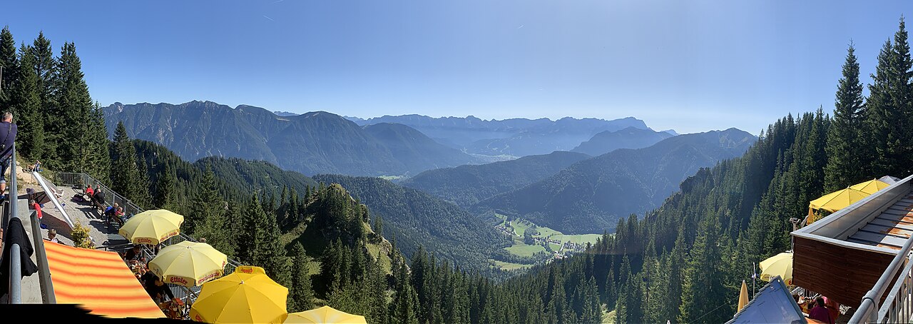
Deutsch: Laber-Berggaststätte im Gebäudekomplex der Seilbahn-Bergstation: Blick gen Süden |
| Date | Taken on 21 September 2019 |
| Source | Self-photographed |
| Author | User:Mateus2019 |
| Camera location | | View this and other nearby images on: OpenStreetMap |
|---|
.jpg¶ms=047.585969_N_0011.102969_E_globe:Earth_type:camera_scale:100000_&language=en)
Licensing[edit]
.jpg&action=edit§ion=2)
This file is licensed under the Creative Commons Attribution 2.0 Germany license.
- You are free:
- to share – to copy, distribute and transmit the work
- to remix – to adapt the work
- Under the following conditions:
- attribution – You must give appropriate credit, provide a link to the license, and indicate if changes were made. You may do so in any reasonable manner, but not in any way that suggests the licensor endorses you or your use.

|
The photographical reproduction of this work is covered under the article § 59 of the German copyright law, which states that "It shall be permissible to reproduce, by painting, drawing, photography or cinematography, works which are permanently located on public ways, streets or places and to distribute and publicly communicate such copies. For works of architecture, this provision shall be applicable only to the external appearance."
As with all other “limits of copyright by legally permitted uses”, no changes to the actual work are permitted under § 62 of the German copyright law (UrhG). See Commons:Copyright rules by territory/Germany#Freedom of panorama for more information.
|
This photograph was taken with an iPhone X
| Annotations | This image is annotated: View the annotations at Commons |
.jpg)
File history
Click on a date/time to view the file as it appeared at that time.
| Date/Time | Thumbnail | Dimensions | User | Comment | |
|---|---|---|---|---|---|
| current | 11:08, 22 September 2019 | 9,214 × 3,265 (9.62 MB) | Mattes (talk | contribs) | Cropped 15 % horizontally, 10 % vertically using CropTool with precise mode. | |
| 05:58, 22 September 2019 | 10,888 × 3,628 (10.08 MB) | Mateus2019 (talk | contribs) | == {{int:filedesc}} == {{Information |Description={{GER}} > {{Bavaria}} > Landkreis Weilheim-Schongau > Oberammergau > Laber (1686 m ü. NHN) {{de|Laber-Bergbahn, Bergstation: Blick gen Süden}} |Date=2019-09-21 |Source={{Self-photographed}} |Author=User:Mattes |Permission= |other_versions= }} {{Location possible}} {{location possible}} == {{int:license-header}} == {{cc-by-2.0-de}} {{FoP-Germany}} {{Taken with iPhone X}} Category:Laber-Bergbahn Category:Zugspitze [[Category:... |
You cannot overwrite this file.
File usage on Commons
The following 4 pages use this file:
.JPG&redirect=no)
File usage on other wikis
The following other wikis use this file:
- Usage on de.wikipedia.org
.jpg&oldid=768857863)