File:Fullarton, Paris and its surrounding fortifications, 1872 - David Rumsey.jpg
Jump to navigation
Jump to search

Size of this preview: 746 × 600 pixels. Other resolutions: 299 × 240 pixels | 597 × 480 pixels | 955 × 768 pixels | 1,274 × 1,024 pixels | 2,547 × 2,048 pixels | 4,676 × 3,760 pixels.
Original file (4,676 × 3,760 pixels, file size: 11.86 MB, MIME type: image/jpeg)
Captions
Captions
Add a one-line explanation of what this file represents
Summary
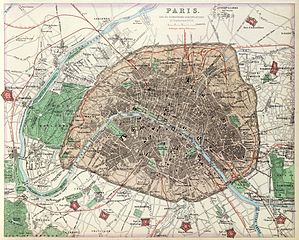
[edit]| Paris and its surrounding fortifications. French Ports & Harbours, and Plan of Paris. By J. Bartholomew, F.R.G.S. XLV. (with) seven inset maps. A. Fullarton & Co. London and Edinburgh. | |
|---|---|
| Author |
Archibald Fullarton and Co. |
| Title |
Paris and its surrounding fortifications. French Ports & Harbours, and Plan of Paris. By J. Bartholomew, F.R.G.S. XLV. (with) seven inset maps. A. Fullarton & Co. London and Edinburgh. |
| Description |
In full color. Seven maps include: (1) Paris. and its surrounding fortifications by J. Bartholomew. F.R.G.S., (2) Boulogne, (3) Le Havre, (4) Cherbourg, (5) Brest, (6) Marseilles, (7) Toulon Harbour. |
| Date | 1872 |
| Dimensions | height: 47 cm (18.5 in); width: 30 cm (11.8 in) |
| Collection | David Rumsey Historical Map Collection |
| Notes | 1st edition 1864; published in 27 parts 1854-62. The date of 1872 is estimated by the Australia map; all the maps are undated and probably date throughout the period 1864 to 1872: the North America map shows Colorado and Russian America while the United States map has no Colorado. The World maps show Alaska. This is the last highly decorative atlas published in England. Even the maps without views or figures are beautifully engraved and colored with a mixture of printed color and hand color. Swanston, Petermann, Bartholomew, Macnab and Johnson engraved the maps. The introduction by Shaw among other things lists important general atlases published over a long period. He lists only one United States atlas, Mitchell's Universal Atlas of 1853! The maps bear a superficial resemblance to Keith Johnston's Royal Atlas. Fullarton frequently gives the sources for his maps - for the United States maps he gives Calvin Smith and Tanner as sources. The atlas is bound in half leather dark green cloth covered boards with "The Royal Illustrated Atlas." stamped in gilt on the cover; the spine reads "Royal Illustrated Atlas" in gold. |
| Source/Photographer | David Rumsey Historical Map Collection |
| Other versions |
|

Licensing
[edit]
|
This work is in the public domain in its country of origin and other countries and areas where the copyright term is the author's life plus 100 years or fewer. | |
| This file has been identified as being free of known restrictions under copyright law, including all related and neighboring rights. | |
File history
Click on a date/time to view the file as it appeared at that time.
| Date/Time | Thumbnail | Dimensions | User | Comment | |
|---|---|---|---|---|---|
| current | 16:34, 7 September 2014 | | 4,676 × 3,760 (11.86 MB) | Paris 16 (talk | contribs) | |
| 16:23, 7 September 2014 |  | 4,676 × 3,760 (12.05 MB) | Paris 16 (talk | contribs) |
You cannot overwrite this file.
File usage on Commons
The following 3 pages use this file: