File:Fort Stanwix, Fort Stanwix National Monument, New York LOC 2009584219.tif
Jump to navigation
Jump to search

Size of this JPG preview of this TIF file: 800 × 559 pixels. Other resolutions: 320 × 224 pixels | 640 × 447 pixels | 1,024 × 715 pixels | 1,280 × 894 pixels | 2,560 × 1,789 pixels | 10,366 × 7,243 pixels.
Original file (10,366 × 7,243 pixels, file size: 214.81 MB, MIME type: image/tiff)
Captions
Captions
Add a one-line explanation of what this file represents
Summary
[edit]| Description |
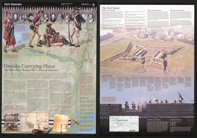
English: Aerial view (partly photographic) of reconstructed Revolutionary War fort in Rome (N.Y.). "*GPO:2009--349-224/80278 Reprint 2007." Title from panel. Oriented with north toward the upper right. Includes text, descriptive index to points of interest, location map, and col. ill. Text, map of "Oneida Carrying Place--six miles that changed the course of America" (showing troop movements of the Saratoga Campaign, June-Oct. 1777), chronology, and ill. (some col.) on verso. Available also through the Library of Congress Web site as a raster image. |
||
| Title | Fort Stanwix, Fort Stanwix National Monument, New York | ||
| Shelf ID | G3804.R7:2F6A3 2007 .U6 | ||
| Date | |||
| Source | https://www.loc.gov/item/2009584219/ | ||
| Author | United States. National Park Service | ||
| Permission (Reusing this file) |
|
||
| Other versions |
|
||
| Location | Fort Stanwix · Fort Stanwix National Monument · Rome · United States · New York · New York (State) · Saratoga Campaign | ||
| Part of | American Memory · General Maps · Catalog · Geography And Map Division | ||
| Subject | Fort Stanwix · Aerial Views · Fort Stanwix National Monument · Rome · United States · Maps · Fort Stanwix (Rome, N.Y.) · Fort Stanwix National Monument (Rome, N.Y.) · Saratoga Campaign, N.Y. · New York (State) |


Licensing
[edit]| This image or media file contains material based on a work of a National Park Service employee, created as part of that person's official duties. As a work of the U.S. federal government, such work is in the public domain in the United States. See the NPS website and NPS copyright policy for more information. |
File history
Click on a date/time to view the file as it appeared at that time.
| Date/Time | Thumbnail | Dimensions | User | Comment | |
|---|---|---|---|---|---|
| current | 08:52, 9 June 2018 |  | 10,366 × 7,243 (214.81 MB) | Fæ (talk | contribs) | LOC Maps https://www.loc.gov/item/2009584219/ #24589 |
You cannot overwrite this file.
File usage on Commons
The following 2 pages use this file: