File:Firth River, tributary and V-shaped valley, Ivvavik National Park, YT.jpg
Original file (6,048 × 3,564 pixels, file size: 18.43 MB, MIME type: image/jpeg)
Captions
DescriptionFirth River, tributary and V-shaped valley, Ivvavik National Park, YT.jpg |
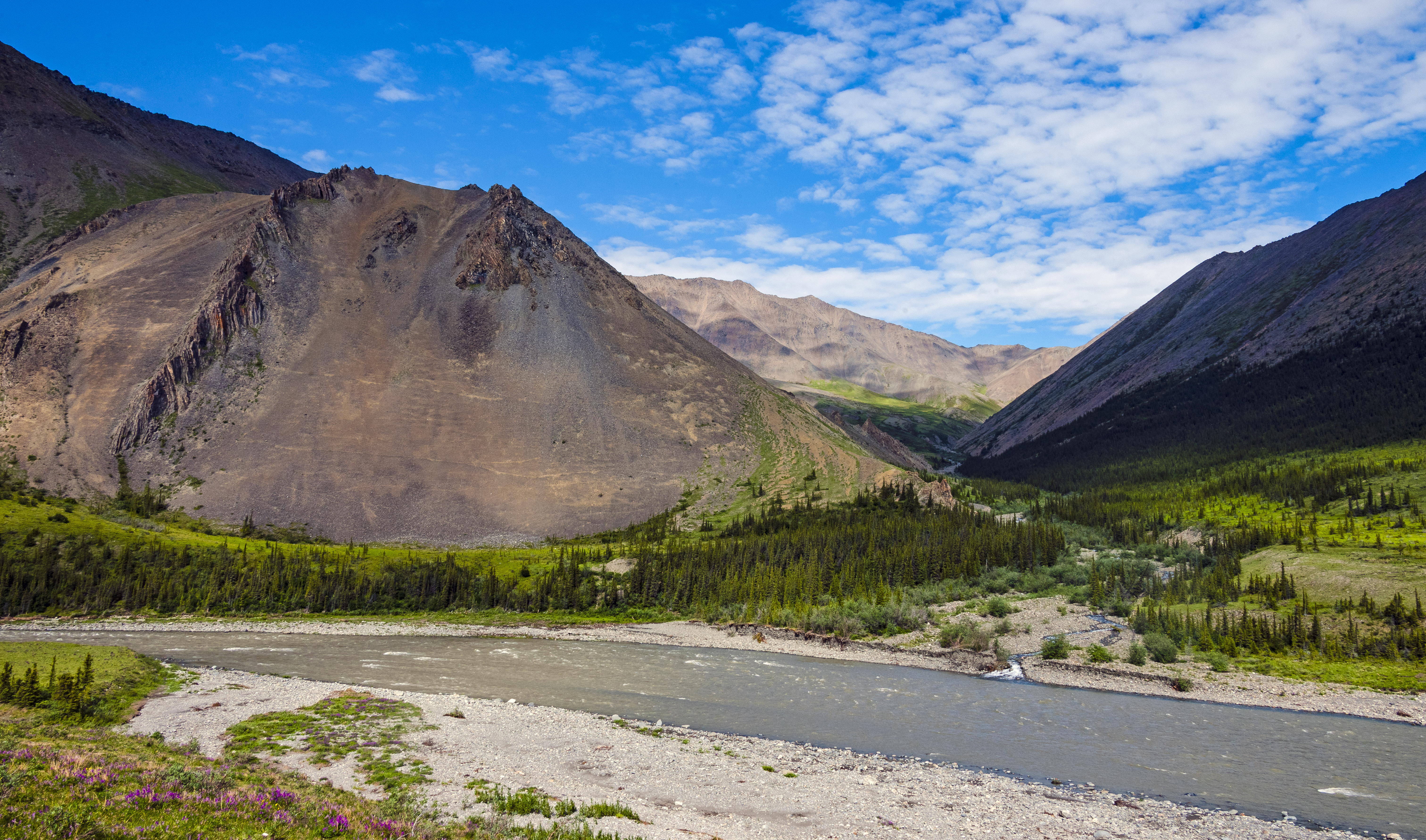
English: V-shaped valley of an unnamed tributary of the Firth River in Canada's Ivvavik National Park, demonstrating that the area, unusually, never experienced the glaciation common elsewhere in North America, and the valley was created purely through the tributary's erosion (as opposed to the U-shaped look of most glacial cirques). |
||
Date | |||
Source | Own work | ||
Author | Daniel Case | ||
Permission (Reusing this file) |
I, the copyright holder of this work, hereby publish it under the following licenses:
This file is licensed under the Creative Commons Attribution-Share Alike 3.0 Unported license.
You may select the license of your choice. |
Camera location | 69° 06′ 26.57″ N, 140° 20′ 05.03″ W | View this and other nearby images on: OpenStreetMap | 69.107380; -140.334730 |
---|
The geographical information in this file was retrospectively estimated.
The location may therefore be somewhat imprecise. Verifying and refining these coordinates is strongly encouraged. |
This image has been assessed using the Quality image guidelines and is considered a Quality image.
العربية ∙ جازايرية ∙ беларуская ∙ беларуская (тарашкевіца) ∙ български ∙ বাংলা ∙ català ∙ čeština ∙ Cymraeg ∙ Deutsch ∙ Schweizer Hochdeutsch ∙ Zazaki ∙ Ελληνικά ∙ English ∙ Esperanto ∙ español ∙ eesti ∙ euskara ∙ فارسی ∙ suomi ∙ français ∙ galego ∙ עברית ∙ हिन्दी ∙ hrvatski ∙ magyar ∙ հայերեն ∙ Bahasa Indonesia ∙ italiano ∙ 日本語 ∙ Jawa ∙ ქართული ∙ 한국어 ∙ kurdî ∙ Lëtzebuergesch ∙ lietuvių ∙ македонски ∙ മലയാളം ∙ मराठी ∙ Bahasa Melayu ∙ Nederlands ∙ Norfuk / Pitkern ∙ polski ∙ português ∙ português do Brasil ∙ rumantsch ∙ română ∙ русский ∙ sicilianu ∙ slovenčina ∙ slovenščina ∙ shqip ∙ српски / srpski ∙ svenska ∙ தமிழ் ∙ తెలుగు ∙ ไทย ∙ Tagalog ∙ Türkçe ∙ toki pona ∙ українська ∙ vèneto ∙ Tiếng Việt ∙ 中文 ∙ 中文(简体) ∙ 中文(繁體) ∙ +/− |
File history
Click on a date/time to view the file as it appeared at that time.
Date/Time | Thumbnail | Dimensions | User | Comment | |
---|---|---|---|---|---|
current | 05:23, 22 April 2017 | 6,048 × 3,564 (18.43 MB) | Daniel Case (talk | contribs) | {{Information |Description ={{en|1=V-shaped valley of an unnamed tributary of the Firth River in Canada's Ivvavik National Park, demonstrating that the area, unusually, never experienced the [[w:Ice Age|... |
You cannot overwrite this file.
File usage on Commons
The following 4 pages use this file:
Metadata
This file contains additional information such as Exif metadata which may have been added by the digital camera, scanner, or software program used to create or digitize it. If the file has been modified from its original state, some details such as the timestamp may not fully reflect those of the original file. The timestamp is only as accurate as the clock in the camera, and it may be completely wrong.
Camera manufacturer | NIKON CORPORATION |
---|---|
Camera model | NIKON D3X |
Exposure time | 1/125 sec (0.008) |
F-number | f/16 |
ISO speed rating | 160 |
Date and time of data generation | 13:49, 5 July 2015 |
Lens focal length | 28 mm |
Orientation | Normal |
Horizontal resolution | 300 dpi |
Vertical resolution | 300 dpi |
Software used | Adobe Photoshop CC 2017 (Windows) |
File change date and time | 01:08, 22 April 2017 |
Exposure Program | Normal program |
Exif version | 2.21 |
Date and time of digitizing | 13:49, 5 July 2015 |
APEX shutter speed | 6.965784 |
APEX aperture | 8 |
APEX exposure bias | −0.5 |
Maximum land aperture | 3.6 APEX (f/3.48) |
Metering mode | Pattern |
Light source | Fine weather |
Flash | Flash did not fire |
DateTime subseconds | 87 |
DateTimeOriginal subseconds | 87 |
DateTimeDigitized subseconds | 87 |
Color space | Uncalibrated |
Sensing method | One-chip color area sensor |
File source | Digital still camera |
Scene type | A directly photographed image |
Custom image processing | Normal process |
Exposure mode | Auto exposure |
White balance | Manual white balance |
Digital zoom ratio | 1 |
Focal length in 35 mm film | 28 mm |
Scene capture type | Standard |
Scene control | None |
Contrast | Normal |
Saturation | Normal |
Sharpness | Normal |
Subject distance range | Unknown |
Serial number of camera | 5028808 |
Lens used | 28.0-300.0 mm f/3.5-5.6 |
Rating (out of 5) | 0 |
Date metadata was last modified | 21:08, 21 April 2017 |
Unique ID of original document | 0C59F671CFE8B740EE925E73506569CE |
- License migration redundant
- GFDL
- CC-BY-SA-3.0
- Self-published work
- Files with coordinates missing SDC location of creation
- Media with estimated locations
- Quality images of Yukon
- Quality images of mountains in Canada
- Quality images of rivers in Canada
- Quality images
- Quality images missing SDC depicts
- Canada photographs taken on 2015-07-05
- Pages with maps