File:Försök til en magnetisk inclinations charta - Kungliga Biblioteket - 10344951.tif
Jump to navigation
Jump to search

Size of this JPG preview of this TIF file: 800 × 551 pixels. Other resolutions: 320 × 220 pixels | 640 × 441 pixels | 1,024 × 705 pixels | 1,280 × 881 pixels | 2,560 × 1,762 pixels | 8,088 × 5,568 pixels.

Original file (8,088 × 5,568 pixels, file size: 257.72 MB, MIME type: image/tiff, 2 pages)
Captions
Captions
Add a one-line explanation of what this file represents
| Title |
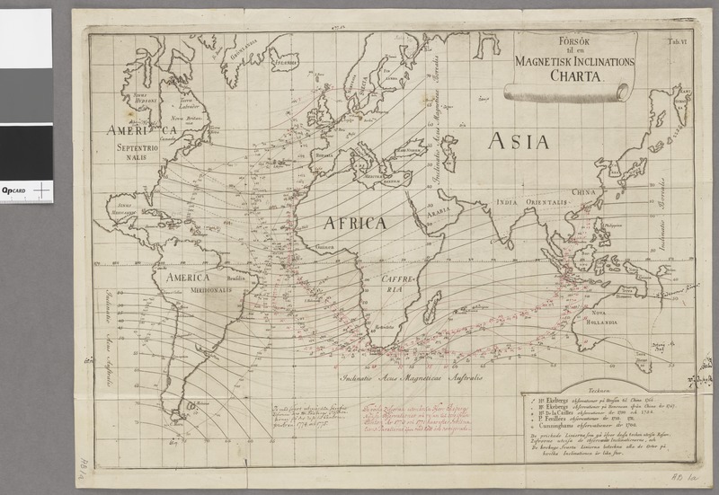
Försök til en magnetisk inclinations charta |
||||||||||||||||||||||||||
| Description |
Svenska: Världskarta som visar den magnetiska inklinationen på olika platser i havet. - Teckenförklaring |
||||||||||||||||||||||||||
| Source |
|
||||||||||||||||||||||||||
| Creator |
Johan Carl Wilcke (1732-1796; creator) |
||||||||||||||||||||||||||
| Permission (Reusing this file) |
Per the source the digitisations are under
|
||||||||||||||||||||||||||
| Geotemporal data | |||||||||||||||||||||||||||
| Scale | 1:70,000,000 | ||||||||||||||||||||||||||
| Georeferencing | If inappropriate please set warp_status = skip to hide. | ||||||||||||||||||||||||||
| Bibliographic data | |||||||||||||||||||||||||||
| Map sheet | 1 karta | ||||||||||||||||||||||||||
| Language | Swedish | ||||||||||||||||||||||||||
| Publisher |
Unknown, Sverige, Sweden |
||||||||||||||||||||||||||
| Archival data | |||||||||||||||||||||||||||
| Collection |
|
||||||||||||||||||||||||||
| Accession number |
10344951 |
||||||||||||||||||||||||||
| Dimensions | plåt 33 x 45 cm | ||||||||||||||||||||||||||
| Medium | kopparstick | ||||||||||||||||||||||||||
| Notes |
Enligt 2. uppl.: Av Carl Johan Wilcke
|
||||||||||||||||||||||||||

File history
Click on a date/time to view the file as it appeared at that time.
| Date/Time | Thumbnail | Dimensions | User | Comment | |
|---|---|---|---|---|---|
| current | 16:47, 21 January 2015 |  | 8,088 × 5,568, 2 pages (257.72 MB) | L PBot (talk | contribs) | {{subst:User:André_Costa_(WMSE)/KB-map |title = Försök til en magnetisk inclinations charta |description = {{sv|Världskarta som visar den magnetiska inklinationen på olika platser i havet. - Teckenförklaring}} |author =... |
You cannot overwrite this file.
File usage on Commons
The following 2 pages use this file: