File:Erickson-1 pia17064-MarsCuriosityRover-MapFromGlenelgToMountSharp-20130605.jpg
Jump to navigation
Jump to search

Size of this preview: 776 × 600 pixels. Other resolutions: 311 × 240 pixels | 621 × 480 pixels | 994 × 768 pixels | 1,280 × 989 pixels | 2,560 × 1,978 pixels | 3,300 × 2,550 pixels.
Original file (3,300 × 2,550 pixels, file size: 1.39 MB, MIME type: image/jpeg)
Captions
Captions
Add a one-line explanation of what this file represents
Summary
[edit]
| Description |
English: http://mars.jpl.nasa.gov/msl/multimedia/images/?ImageID=5326
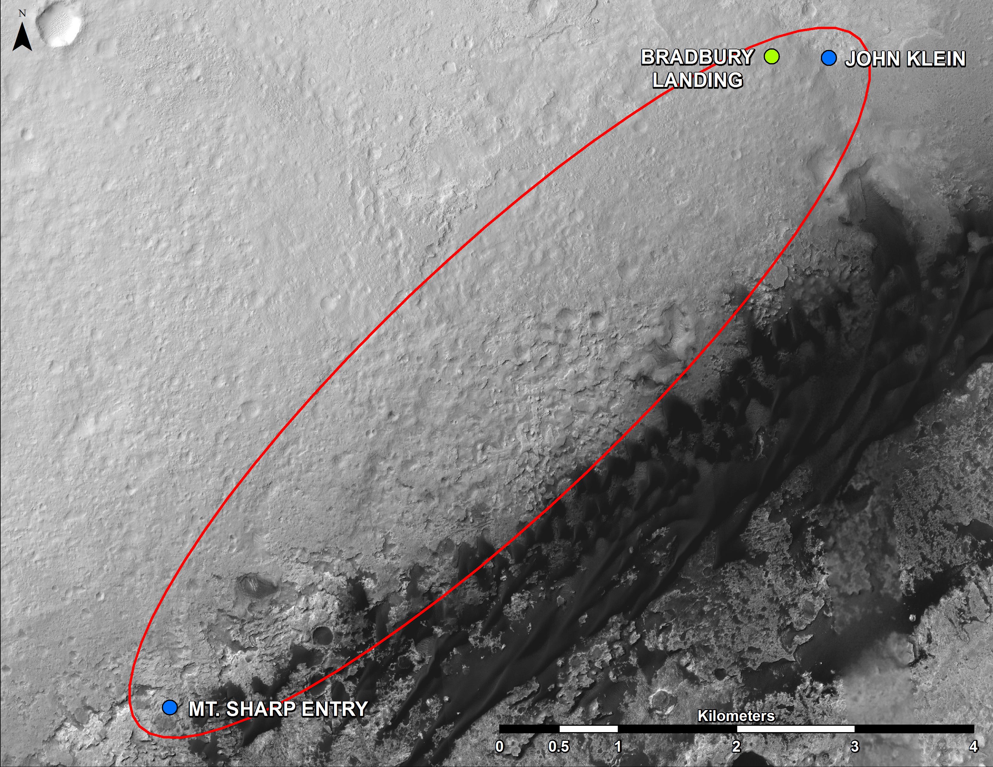
06.05.2013 From 'Glenelg' to Mount Sharp This map shows where NASA's Mars rover Curiosity landed in August 2012 at "Bradbury Landing"; the area where the rover worked from November 2012 through May 2013 at and near the "John Klein" target rock in the "Glenelg" area; and the mission's next major destination, the entry point to the base of Mount Sharp. The precise route has not been determined, but the rover's path will likely be within the swath outlined in red. All of these features are inside Gale Crater. North is toward the top. The scale bar is 4 kilometers (2.5 miles). The base map is an image acquired by the High Resolution Imaging Science Experiment (HiRISE) camera on NASA's Mars Reconnaissance Orbiter. |
| Date | |
| Source | http://mars.jpl.nasa.gov/msl/images/Erickson-1_pia17064-full.jpg |
| Author | NASA/JPL-Caltech/Univ. of Arizona |
Licensing
[edit]
| This file is in the public domain in the United States because it was solely created by NASA. NASA copyright policy states that "NASA material is not protected by copyright unless noted". (See Template:PD-USGov, NASA copyright policy page or JPL Image Use Policy.) | ||
 |
Warnings:
|
File history
Click on a date/time to view the file as it appeared at that time.
| Date/Time | Thumbnail | Dimensions | User | Comment | |
|---|---|---|---|---|---|
| current | 22:25, 6 June 2013 | | 3,300 × 2,550 (1.39 MB) | Drbogdan (talk | contribs) | User created page with UploadWizard |
You cannot overwrite this file.
File usage on Commons
The following page uses this file: