File:Engineering work has not been completed at West Leigh, Havant, and no trains are running on 7 November 2022 0830 local (3116).jpg
Jump to navigation
Jump to search

Size of this preview: 800 × 600 pixels. Other resolutions: 320 × 240 pixels | 640 × 480 pixels | 1,024 × 768 pixels | 1,280 × 960 pixels | 2,560 × 1,920 pixels | 4,000 × 3,000 pixels.
Original file (4,000 × 3,000 pixels, file size: 4.72 MB, MIME type: image/jpeg)
Captions
Captions
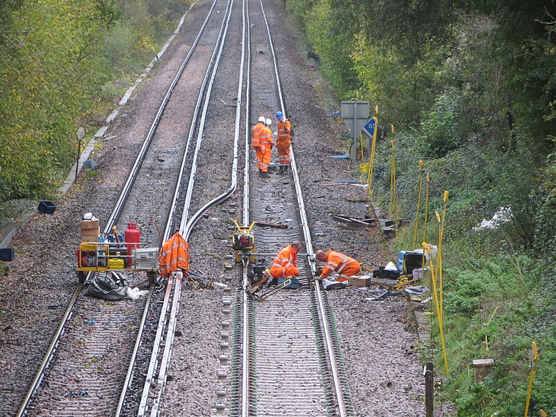
Engineering work has not been completed at West Leigh, Havant, and no trains are running on 7 November 2022 0830 local
Summary[edit]
.jpg&action=edit§ion=1)
| Description |
English: The RMT had called called off strikes on Sunday 5th and Monday 7th November 2022. At about 14:30 on Sunday 6th November planned tracked renewals near West Leigh, Havant, were underway although at that point there appears little activity with the job incomplete, unmanned JCBs on the rails and track waiting to be ballasted and have chairs fitted to the concrete sleepers for the 3rd electricity conductor rail widely used in the UK SR region. In the event by 8:30 on the monday the ballast and chairs were fitted but the conductor rail remained absent and engineers still working on the job meaning trains could not run.
Zooming in on the image reveals a little about the tools and lightweight rail vehicles in use at the time the image was taken. The photo was take from a distance of about 200m on quite a high optical zoom, the sx240 is perhaps a 10-year old compact camera but it does have image stabilisation and the bridge parapet could be used for support. However distortion can be seen by railways lines that should obviously be straight. The 3rd rail used to conduct electricity to the trains has been bent of the way and it is probably most of it will be reseated back on the chairs that are on every 4th or so sleeper at some point. Compared to the previous day the sleepers on the new track are seated in stone ballasts and have the chairs fitted. |
| Date | |
| Source | https://www.flickr.com/photos/196366907@N03/52483596985/ |
| Author | Deirge (Del) |
| Camera location | | View this and other nearby images on: OpenStreetMap |
|---|
.jpg¶ms=050.866470_N_-000.963880_E_globe:Earth_type:camera_heading:20.00&language=en)
| Object location | | View this and other nearby images on: OpenStreetMap |
|---|
.jpg¶ms=050.868000_N_-000.962900_E_globe:Earth_class:object_type:object__&language=en)
Licensing[edit]
.jpg&action=edit§ion=2)
This file is licensed under the Creative Commons Attribution-Share Alike 2.0 Generic license.
- You are free:
- to share – to copy, distribute and transmit the work
- to remix – to adapt the work
- Under the following conditions:
- attribution – You must give appropriate credit, provide a link to the license, and indicate if changes were made. You may do so in any reasonable manner, but not in any way that suggests the licensor endorses you or your use.
- share alike – If you remix, transform, or build upon the material, you must distribute your contributions under the same or compatible license as the original.
| This image was originally posted to Flickr by Deirge (Del) at https://flickr.com/photos/196366907@N03/52483596985. It was reviewed on 7 November 2022 by FlickreviewR 2 and was confirmed to be licensed under the terms of the cc-by-sa-2.0. |
File history
Click on a date/time to view the file as it appeared at that time.
| Date/Time | Thumbnail | Dimensions | User | Comment | |
|---|---|---|---|---|---|
| current | 09:51, 7 November 2022 | | 4,000 × 3,000 (4.72 MB) | DeirgeDel (talk | contribs) | Uploaded a work by Deirge (Del) from https://www.flickr.com/photos/196366907@N03/52483596985/ with UploadWizard |
You cannot overwrite this file.
File usage on Commons
The following 4 pages use this file:
.jpg&oldid=703662774)