File:Edinburgh Trams line 1.png
Jump to navigation
Jump to search

Size of this preview: 800 × 260 pixels. Other resolutions: 320 × 104 pixels | 640 × 208 pixels | 1,800 × 584 pixels.
Original file (1,800 × 584 pixels, file size: 137 KB, MIME type: image/png)
Captions
Captions
Add a one-line explanation of what this file represents
| Description |
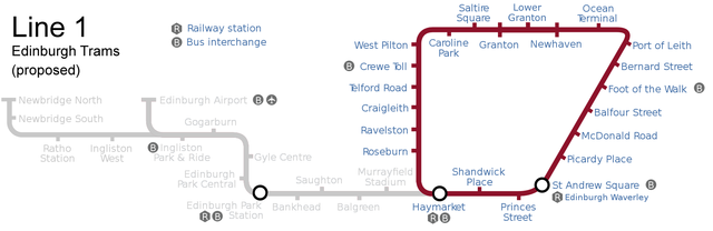
English: A map showing the extent of the track and stops of the Edinburgh Trams system which actually gained parliamentary approval in 2006 (not shown is the track needed for Line 3, which was also proposed but not approved). Highlighted here is 'Line 2', while in the background is 'Line 1', which would have operated as a linear service, running from either Newbridge North or the airport, to st Andrew Square. After various revisions and cancellations, the only part of the track that was eventually built was the section from the airport to York Place (between St Andrew Square and Picardy Place), which runs as a single line (opened in 2014). |
| Date | (UTC) |
| Source | |
| Author |
|
| This is a retouched picture, which means that it has been digitally altered from its original version. Modifications: changed colours to highlight line 1 as described in main article. The original can be viewed here: Edinburgh tramway map.svg:
|
I, the copyright holder of this work, hereby publish it under the following licenses:
This file is licensed under the Creative Commons Attribution-Share Alike 3.0 Unported, 2.5 Generic, 2.0 Generic and 1.0 Generic license.
- You are free:
- to share – to copy, distribute and transmit the work
- to remix – to adapt the work
- Under the following conditions:
- attribution – You must give appropriate credit, provide a link to the license, and indicate if changes were made. You may do so in any reasonable manner, but not in any way that suggests the licensor endorses you or your use.
- share alike – If you remix, transform, or build upon the material, you must distribute your contributions under the same or compatible license as the original.

|
Permission is granted to copy, distribute and/or modify this document under the terms of the GNU Free Documentation License, Version 1.2 or any later version published by the Free Software Foundation; with no Invariant Sections, no Front-Cover Texts, and no Back-Cover Texts. A copy of the license is included in the section entitled GNU Free Documentation License. |
You may select the license of your choice.
Original upload log[edit]
This image is a derivative work of the following images:
- File:Edinburgh_tramway_map.svg licensed with Cc-by-sa-3.0,2.5,2.0,1.0, GFDL
- 2007-11-17T17:48:00Z DavidArthur 850x275 (74983 Bytes) {{Information |Description={{en|[[Image:Flag of the United Kingdom.svg|20px|English]] A map of the [[:en:Edinburgh Tram Network|proposed Edinburgh tramway]].}} |Source=self-made |Date=17 November 2007 |Author= [[User:DavidArt
Uploaded with derivativeFX
File history
Click on a date/time to view the file as it appeared at that time.
| Date/Time | Thumbnail | Dimensions | User | Comment | |
|---|---|---|---|---|---|
| current | 13:08, 12 January 2010 | 1,800 × 584 (137 KB) | Cnbrb (talk | contribs) | {{Information |Description={{en|20px|English A map of the original route proposal for Line 1 of the proposed Edinburgh tramway.}} |Source=*File:Edinburgh_tramway_map.svg |Date=2 |
You cannot overwrite this file.
File usage on Commons
The following page uses this file:
File usage on other wikis
The following other wikis use this file:
- Usage on en.wikipedia.org