File:Easter Island district map.jpg
Jump to navigation
Jump to search

Size of this preview: 800 × 549 pixels. Other resolutions: 320 × 220 pixels | 640 × 439 pixels | 1,024 × 703 pixels | 1,280 × 878 pixels | 1,536 × 1,054 pixels.
Original file (1,536 × 1,054 pixels, file size: 527 KB, MIME type: image/jpeg)
Captions
Captions
Add a one-line explanation of what this file represents
Summary
[edit]| Description |
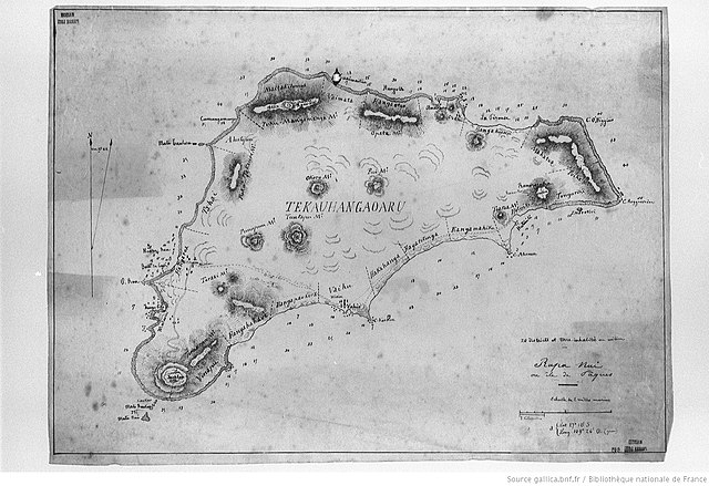
English: map of Easter island, Eastern Pacific Ocean, Chile, original size 26 cm × 18 cm, with historic districts. 20 inhabited coastal districts listed clockwise, starting at current capital Hanga Roa (Bold until middle of 19th century):
|
| Date | |
| Source | http://gallica.bnf.fr/ark:/12148/btv1b14000189/f48.item.r=carte%20rapanui.zoom |
| Author |
Pierre Loti (1850-1923) Joseph Bernard (18..-19..?) |
| Other versions |

Licensing
[edit]
|
This work is in the public domain in its country of origin and other countries and areas where the copyright term is the author's life plus 70 years or fewer. This work is in the public domain in the United States because it was published (or registered with the U.S. Copyright Office) before January 1, 1929. | |
| This file has been identified as being free of known restrictions under copyright law, including all related and neighboring rights. | |
File history
Click on a date/time to view the file as it appeared at that time.
| Date/Time | Thumbnail | Dimensions | User | Comment | |
|---|---|---|---|---|---|
| current | 16:14, 1 February 2018 | | 1,536 × 1,054 (527 KB) | Ratzer (talk | contribs) | User created page with UploadWizard |
You cannot overwrite this file.
File usage on Commons
The following page uses this file:
File usage on other wikis
The following other wikis use this file:
- Usage on de.wikipedia.org