File:Dobrizhoffer Paraguay.jpg
Jump to navigation
Jump to search
Size of this preview: 478 × 599 pixels. Other resolutions: 191 × 240 pixels | 383 × 480 pixels | 613 × 768 pixels | 817 × 1,024 pixels | 1,590 × 1,993 pixels.
Original file (1,590 × 1,993 pixels, file size: 623 KB, MIME type: image/jpeg)
Captions
Captions
Add a one-line explanation of what this file represents
Summary
[edit]
| Description |
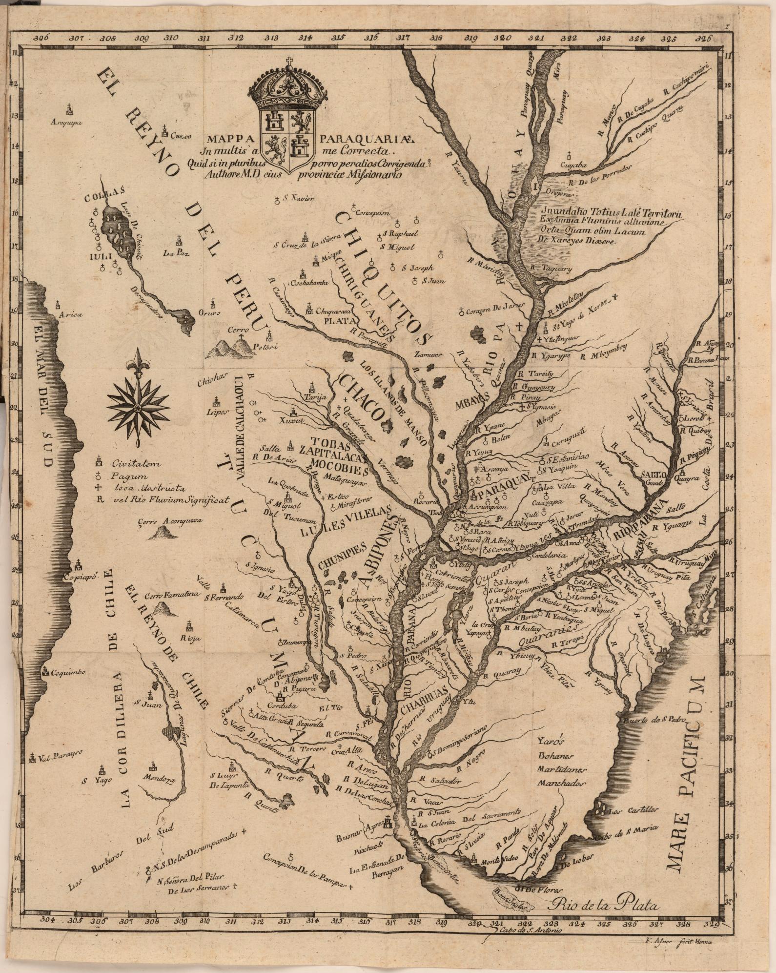
English: Map of Paraguay showing the Rio de la Plata. Cartographic elements includes degrees of latitude and longitude, compass rose, locations of missions, rivers and streams, notable mountains including Potosí, shoals or sea banks, and lakes. Also includes royal coat of arms of Spain. Engraved map; ink on paper.
Español: Mapa de Paraguay incluye el Rio de la Plata. Muestra latitud y longitud, rose de los vientos, misiones, ríos y corrientes, montañas importantes como Potosí, la orilla del mar, y lagos. También incluye el escudo de armas de la realeza española. Mapa grabado; tinte en papel. |
| Date | |
| Source |
Historia de Abiponibus equestri (Vienna: 1784) Volumes 1-3 digitized on Internet Archive |
| Author | Martin Dobrizhoffer |
Licensing
[edit]
|
This work is in the public domain in its country of origin and other countries and areas where the copyright term is the author's life plus 70 years or fewer. This work is in the public domain in the United States because it was published (or registered with the U.S. Copyright Office) before January 1, 1929. | |
| This file has been identified as being free of known restrictions under copyright law, including all related and neighboring rights. | |
File history
Click on a date/time to view the file as it appeared at that time.
| Date/Time | Thumbnail | Dimensions | User | Comment | |
|---|---|---|---|---|---|
| current | 16:09, 7 May 2020 | | 1,590 × 1,993 (623 KB) | Gpcantu (talk | contribs) | Uploaded a work by Martin Dobrizhoffer from Historia de Abiponibus equestri (Vienna: 1784) [https://archive.org/search.php?query=creator%3A%22Dobrizhoffer%2C%20Martin%2C%201717-1791%22%20J784%20D634h Volumes 1-3 digitized on Internet Archive] with UploadWizard |
You cannot overwrite this file.
File usage on Commons
There are no pages that use this file.
File usage on other wikis
The following other wikis use this file:
- Usage on es.wikipedia.org
- Usage on pl.wikipedia.org