File:Corpus der römischen Funde im europäischen Barbaricum. Polen 4. Lubliner Land (verso).pdf
Jump to navigation
Jump to search

Size of this JPG preview of this PDF file: 412 × 599 pixels. Other resolutions: 165 × 240 pixels | 330 × 480 pixels | 528 × 768 pixels | 705 × 1,024 pixels | 2,479 × 3,602 pixels.
Original file (2,479 × 3,602 pixels, file size: 1.59 MB, MIME type: application/pdf)
Captions
Captions
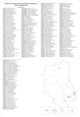
Corpus of Roman finds in the European Barbaricum. Poland 4. Lublin Land (map reverse)
Summary[edit]
| Title |
English: 'Corpus der römischen Funde im europäischen Barbaricum. Polen 4. Lubliner Land (verso)' |
| Description |
English: The map presents distribution of archaeological sites of Roman finds in the Lubelskie Voivodship as listed in 2021 Corpus der römischen Funde im europäischen Barbaricum (CBRF). Poland, vol. 4. Lublin Land. Polish Academy of Arts and Sciences, ISBN: 978-83-66210-21-9. The Corpus was elaborated by M. Gładysz-Juścińska, A. Kokowski, B. Niezabitowska-Wiśniewska in cooperation with J. Bagińska, M. Barakszyn, B. Bartecki, M. Bienia, S. Hanejko, A. Hyrchała, M. Koperwas, J. Kuna, G. Kuś, P. Lis, P. Łuczkiewicz, T. Markiewicz, T. Mazurek, A. Mucha, K. Myzgin, S. Sadowski, M. Stasiak-Cyran and M. Zawadzki. The main map scale is 1:450,000, with four cartons at scale 1:100,000. The map was elaborated at Maria Cuie-Skłodowska University in Lublin by A. Kokowski, J. Kuna and M. Zawadzki.
Deutsch: Die Karte zeigt die Verteilung der archäologischen Fundstellen in der Woiwodschaft Lubelskie, wie sie im Jahr 2021 im Corpus der römischen Funde im europäischen Barbaricum (CBRF) aufgeführt sind. Polen, Bd. 4. Lubliner Land. Polnische Akademie der Künste und Wissenschaften, ISBN: 978-83-66210-21-9. Das Corpus wurde von M. Gładysz-Juścińska, A. Kokowski, B. Niezabitowska-Wiśniewska in Zusammenarbeit mit J. Bagińska, M. Barakszyn, B. Bartecki, M. Bienia, S. Hanejko, A. Hyrchała, M. Koperwas, J. Kuna, G. Kuś, P. Lis, P. Łuczkiewicz, T. Markiewicz, T. Mazurek, A. Mucha, K. Myzgin, S. Sadowski, M. Stasiak-Cyran und M. Zawadzki. Der Hauptkartenmaßstab ist 1:450.000, mit vier Kartons im Maßstab 1:100.000. Die Karte wurde an der Maria-Cuie-Skłodowska-Universität in Lublin von A. Kokowski, J. Kuna und M. Zawadzki ausgearbeitet.
Polski: Mapa przedstawia rozmieszczenie stanowisk archeologicznych ze znaleziskami rzymskimi na terenie województwa lubelskiego, wymienionych w 2021 r. w Corpus der römischen Funde im europäischen Barbaricum (CBRF). Polen 4. Lubliner-Land. Polska Akademia Umiejętności, ISBN: 978-83-66210-21-9. Korpus został opracowany przez M. Gładysz-Juścińską, A. Kokowskiego, B. Niezabitowską-Wiśniewską we współpracy z J. Bagińską, M. Barakszyn, B. Barteckim, M. Bienia, S. Hanejko, A. Hyrchała, M. Koperwas, J. Kuna, G. Kuś, P. Lis, P. Łuczkiewicz, T. Markiewicz, T. Mazurek, A. Mucha, K. Myzgin, S. Sadowski, M. Stasiak-Cyran i M. Zawadzkim. Skala mapy głównej to 1:450 000, plus cztery kartony w skali 1:100 000. Mapa została opracowana na Uniwersytecie Marii Cuie-Skłodowskiej w Lublinie przez A. Kokowskiego, J. Kunę i M. Zawadzkiego. |
| Date | |
| Source | Own work |
| Creator | |
| Geotemporal data | |
| Map location | Lubelskie Voivodship, Poland |
| Spatial reference system | ETRS_1989_Poland_CS2000 - modified Zone 7.5, central meridian 23.0, halfway between EPSG:2178 and EPSG:2179 |
| Archival data | |
| Dimensions | height: 61 cm (24 in); width: 42 cm (16.5 in) |
| Other versions | Corpus Lublin Land (at arcgis.com) |
| Camera location | | View this and other nearby images on: OpenStreetMap |
|---|
Licensing[edit]
I, the copyright holder of this work, hereby publish it under the following license:
This file is licensed under the Creative Commons Attribution-Share Alike 4.0 International license.
- You are free:
- to share – to copy, distribute and transmit the work
- to remix – to adapt the work
- Under the following conditions:
- attribution – You must give appropriate credit, provide a link to the license, and indicate if changes were made. You may do so in any reasonable manner, but not in any way that suggests the licensor endorses you or your use.
- share alike – If you remix, transform, or build upon the material, you must distribute your contributions under the same or compatible license as the original.
File history
Click on a date/time to view the file as it appeared at that time.
| Date/Time | Thumbnail | Dimensions | User | Comment | |
|---|---|---|---|---|---|
| current | 07:37, 19 January 2023 |  | 2,479 × 3,602 (1.59 MB) | Jakub Kuna (talk | contribs) | Uploaded own work with UploadWizard |
You cannot overwrite this file.
File usage on Commons
There are no pages that use this file.