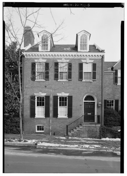
File:Close view of the north end of the west elevation, with scale - Ambassador Bruce House, 1422 Thirty-Fifth Street, Northwest, Washington, District of Columbia, DC HABS DC,GEO,229-5.tif
Jump to navigation
Jump to search
Size of this JPG preview of this TIF file: 435 × 599 pixels. Other resolutions: 174 × 240 pixels | 348 × 480 pixels | 558 × 768 pixels | 743 × 1,024 pixels | 1,487 × 2,048 pixels | 3,631 × 5,000 pixels.
Original file (3,631 × 5,000 pixels, file size: 17.32 MB, MIME type: image/tiff)
Captions
Captions
Add a one-line explanation of what this file represents
Summary[edit]
| Close view of the north end of the west elevation, with scale - Ambassador Bruce House, 1422 Thirty-Fifth Street, Northwest, Washington, District of Columbia, DC | ||||
|---|---|---|---|---|
| Photographer |
Boucher, Jack E. Related names:
|
|||
| Title |
Close view of the north end of the west elevation, with scale - Ambassador Bruce House, 1422 Thirty-Fifth Street, Northwest, Washington, District of Columbia, DC |
|||
| Depicted place | District of Columbia; District of Columbia; Washington | |||
| Date | 2000 | |||
| Dimensions | 5 x 7 in. | |||
| Current location |
Library of Congress Prints and Photographs Division Washington, D.C. 20540 USA http://hdl.loc.gov/loc.pnp/pp.print |
|||
| Accession number |
HABS DC,GEO,229-5 |
|||
| Credit line |
|
|||
| Notes |
|
|||
| References |
|
|||
| Source | https://www.loc.gov/pictures/item/dc0978.photos.378913p | |||
| Permission (Reusing this file) |
|
|||

| Object location | | View this and other nearby images on: OpenStreetMap |
|---|
File history
Click on a date/time to view the file as it appeared at that time.
| Date/Time | Thumbnail | Dimensions | User | Comment | |
|---|---|---|---|---|---|
| current | 05:18, 11 July 2014 |  | 3,631 × 5,000 (17.32 MB) | Fæ (talk | contribs) | GWToolset: Creating mediafile for Fæ. HABS 08 July 2014 (701:800) |
You cannot overwrite this file.
File usage on Commons
The following page uses this file: