File:Caucasus region Ovest.jpg
Jump to navigation
Jump to search
Size of this preview: 618 × 600 pixels. Other resolutions: 247 × 240 pixels | 494 × 480 pixels | 651 × 632 pixels.
Original file (651 × 632 pixels, file size: 94 KB, MIME type: image/jpeg)
Captions
Captions
Add a one-line explanation of what this file represents
Summary[edit]
| Description |
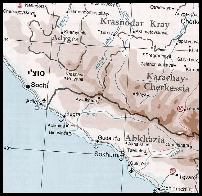
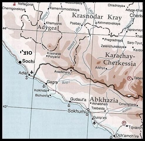
English: Map of the North Caucasus region, in 1994.
Includes northwest Georgia (Abkhazia) and southwest Russia (Krasnodar Krai and Karachay-Cherkessia). Français : Carte du Caucase en 1994 |
|||
| Date | ||||
| Source | University of Texas Library [1] | |||
| Author | CIA [2] | |||
| Permission (Reusing this file) |
|
|||
| Other versions |


![[1]](http://www.lib.utexas.edu/maps/commonwealth/caucasus_region_1994.jpg)
This image was intentionally uploaded with a border. Please do not remove the border. Upload a new version under a different filename without a border if you want a version without a border.
|
File history
Click on a date/time to view the file as it appeared at that time.
| Date/Time | Thumbnail | Dimensions | User | Comment | |
|---|---|---|---|---|---|
| current | 23:03, 10 November 2015 | | 651 × 632 (94 KB) | BurritoBazooka (talk | contribs) | Reverted to version as of 15:37, 30 April 2010 (UTC) per image: "This image was intentionally uploaded with a border. Please do not remove it. Upload a new version under a different filename without a border if you want a version without a border." |
| 20:43, 14 July 2010 |  | 629 × 609 (91 KB) | Cropbot (talk | contribs) | upload cropped version, operated by User:Beao. Summary: cropped | |
| 15:37, 30 April 2010 |  | 651 × 632 (94 KB) | Ori~ (talk | contribs) | Reverted to version as of 22:07, 16 July 2008 | |
| 11:09, 30 April 2010 |  | 631 × 612 (92 KB) | DieBuche (talk | contribs) | -border | |
| 22:07, 16 July 2008 |  | 651 × 632 (94 KB) | Nard the Bard (talk | contribs) | Reverted to version as of 23:22, 11 January 2008 | |
| 19:47, 16 July 2008 |  | 631 × 612 (92 KB) | Finavon (talk | contribs) | border cropped with Paint.Net | |
| 23:22, 11 January 2008 |  | 651 × 632 (94 KB) | Ori~ (talk | contribs) | {{Information |Description= |Source= |Date= |Author= |Permission= |other_versions= }} | |
| 20:47, 1 January 2008 |  | 651 × 632 (93 KB) | Ori~ (talk | contribs) | {{Information |Description= |Source= |Date= |Author= |Permission= |other_versions= }} | |
| 13:03, 1 January 2008 |  | 631 × 612 (89 KB) | Ori~ (talk | contribs) | {{Information |Description= |Source= |Date= |Author= |Permission= |other_versions= }} | |
| 02:35, 26 December 2007 |  | 631 × 612 (90 KB) | Ori~ (talk | contribs) | source: http://commons.wikimedia.org/wiki/Image:Caucasus_region_1994.jpg {{Information |Description= {{en|Map of the Caucasus region in 1994}} {{fr|Carte du Caucase en 1994}} |Source=University of Texas Library [http://www.lib.utexas.edu/maps/commonweal |
You cannot overwrite this file.
File usage on Commons
The following 5 pages use this file:
File usage on other wikis
The following other wikis use this file:
- Usage on el.wikipedia.org
- Usage on he.wikipedia.org
- Usage on it.wikipedia.org
- Usage on www.wikidata.org