File:Carte universelle du commerce, c'est a dire carte hidrographique, ou sont exactement decrites, les costes des 4 parties du monde, par P.Du-Val Geographe Ordinaire du Roy. 1686. A Paris. Chez l'auteur, en l'Isle du Palais, RMG F0342.tiff

Original file (7,229 × 5,196 pixels, file size: 107.47 MB, MIME type: image/tiff)
Captions
Captions
Summary[edit]
| Author |
Pierre Du Val |
| Description |
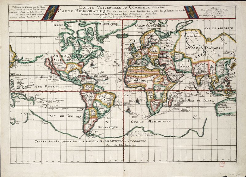
English: Carte universelle du commerce, c'est a dire carte hidrographique, ou sont exactement decrites, les costes des 4 parties du monde, par P.Du-Val Geographe Ordinaire du Roy. 1686. A Paris. Chez l'auteur, en l'Isle du Palais, sur le quay de l'Orloge, au coin de la rue de Harlay. Avec privilege du Roy pour vingt ans.Single sheet, engraving coloured in outline. Scale: [circa 1:55,000,000]. Plane projection. Prime meridian through the Canary Islands. Third state of Du Val's map (earlier editions 1674 and 1677).
There is a key to the track conventions at top left and four ships are drawn sailing on the routes.
This chart plots the routes, from France and Spain, of the outward and return voyages to the West Indies and East Indies, with branches for different destinations. The northern route to India and the East Indies, which was used by French and English ships, is shown, rather than the southern route across the Indian Ocean generally used by Dutch mariners. |
| Date | 1686 |
| Dimensions | Printed area 37 x 54cm, on sheet 42 x 58.5cm. |
| Source/Photographer | http://collections.rmg.co.uk/collections/objects/540217 |
| Permission (Reusing this file) |
The original artefact or artwork has been assessed as public domain by age, and faithful reproductions of the two dimensional work are also public domain. No permission is required for reuse for any purpose. The text of this image record has been derived from the Royal Museums Greenwich catalogue and image metadata. Individual data and facts such as date, author and title are not copyrightable, but reuse of longer descriptive text from the catalogue may not be considered fair use. Reuse of the text must be attributed to the "National Maritime Museum, Greenwich, London" and a Creative Commons CC-BY-NC-SA-3.0 license may apply if not rewritten. Refer to Royal Museums Greenwich copyright. |
| Identifier | Acquisition Number: NA1970-2. id number: G201:1/32 |
| Collection | Charts and maps |
Licensing[edit]
|
This is a faithful photographic reproduction of a two-dimensional, public domain work of art. The work of art itself is in the public domain for the following reason:
The official position taken by the Wikimedia Foundation is that "faithful reproductions of two-dimensional public domain works of art are public domain".
This photographic reproduction is therefore also considered to be in the public domain in the United States. In other jurisdictions, re-use of this content may be restricted; see Reuse of PD-Art photographs for details. | ||||
File history
Click on a date/time to view the file as it appeared at that time.
| Date/Time | Thumbnail | Dimensions | User | Comment | |
|---|---|---|---|---|---|
| current | 02:27, 28 August 2017 |  | 7,229 × 5,196 (107.47 MB) | Fæ (talk | contribs) | Royal Museums Greenwich Charts and maps, http://collections.rmg.co.uk/collections/objects/540217 |
You cannot overwrite this file.
File usage on Commons
The following page uses this file:
File usage on other wikis
The following other wikis use this file:
- Usage on fr.wikipedia.org