File:Buurtspoorwegen Oost-Vlaanderen.png
Jump to navigation
Jump to search
Size of this preview: 742 × 600 pixels. Other resolutions: 297 × 240 pixels | 594 × 480 pixels | 950 × 768 pixels | 1,267 × 1,024 pixels | 2,230 × 1,803 pixels.
Original file (2,230 × 1,803 pixels, file size: 1.6 MB, MIME type: image/png)
Captions
Captions
Add a one-line explanation of what this file represents
Summary[edit]
| Description |
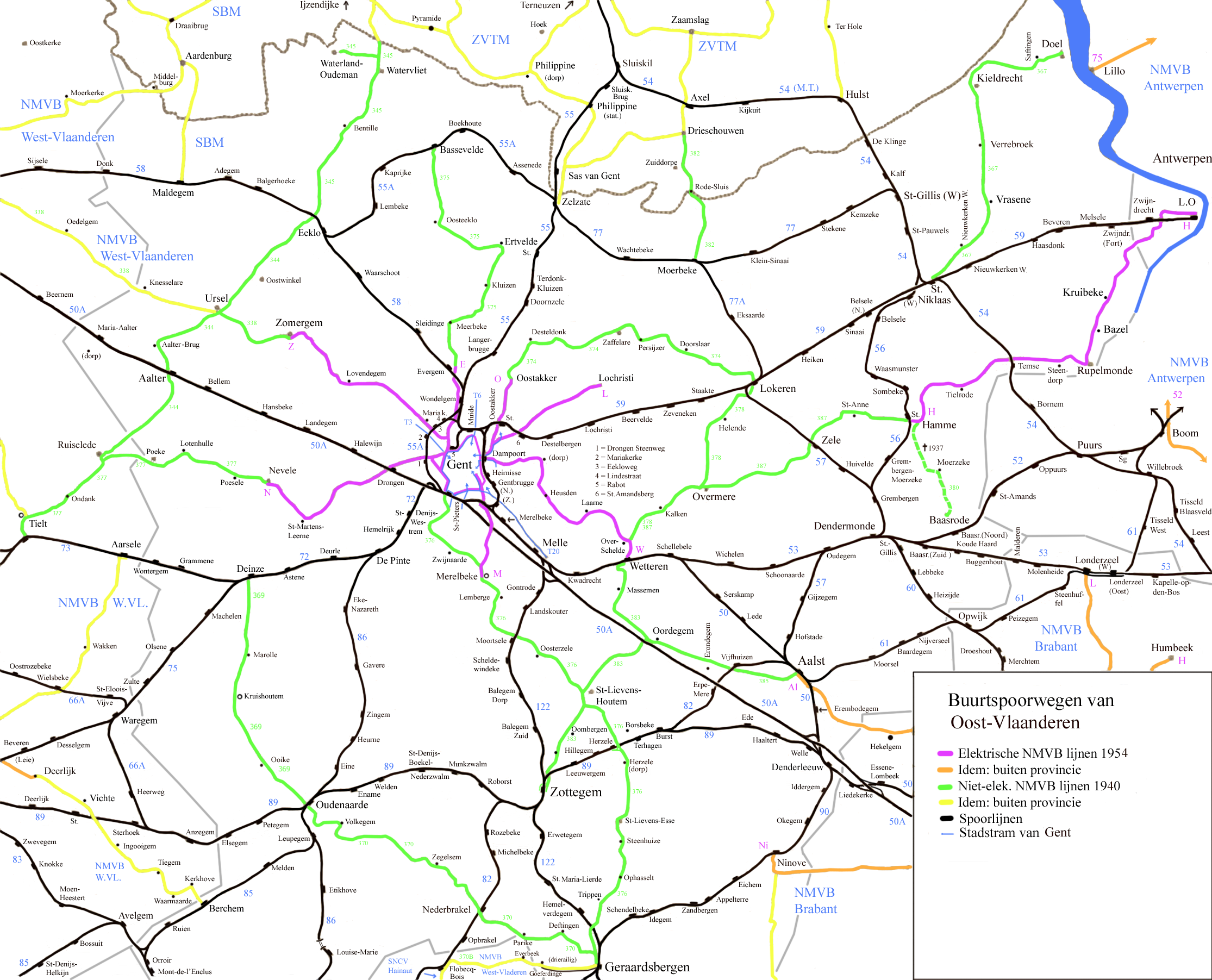
English: Map off the vicinal railways in the province off East Flandres.
Nederlands: Kaart van de buurtspoorwegen in de provincie Oost-Vlaanderen. |
| Date | 8-1-2009 |
| Source | Own work |
| Author | Smiley.toerist |
| Other versions |
Detail Ghent  |
Licensing[edit]
I, the copyright holder of this work, hereby publish it under the following licenses:

|
Permission is granted to copy, distribute and/or modify this document under the terms of the GNU Free Documentation License, Version 1.2 or any later version published by the Free Software Foundation; with no Invariant Sections, no Front-Cover Texts, and no Back-Cover Texts. A copy of the license is included in the section entitled GNU Free Documentation License. |
This file is licensed under the Creative Commons Attribution-Share Alike 3.0 Unported, 2.5 Generic, 2.0 Generic and 1.0 Generic license.
- You are free:
- to share – to copy, distribute and transmit the work
- to remix – to adapt the work
- Under the following conditions:
- attribution – You must give appropriate credit, provide a link to the license, and indicate if changes were made. You may do so in any reasonable manner, but not in any way that suggests the licensor endorses you or your use.
- share alike – If you remix, transform, or build upon the material, you must distribute your contributions under the same or compatible license as the original.
You may select the license of your choice.
File history
Click on a date/time to view the file as it appeared at that time.
| Date/Time | Thumbnail | Dimensions | User | Comment | |
|---|---|---|---|---|---|
| current | 16:02, 20 May 2021 | | 2,230 × 1,803 (1.6 MB) | Arflhn (talk | contribs) | suite 383 |
| 15:57, 20 May 2021 |  | 2,230 × 1,803 (1.6 MB) | Arflhn (talk | contribs) | correction mineures 345 et 378 | |
| 12:44, 25 April 2021 |  | 2,230 × 1,803 (1.6 MB) | Arflhn (talk | contribs) | Deinze - Oudenaarde timetable n°369 | |
| 16:14, 28 August 2020 |  | 2,230 × 1,803 (1.34 MB) | Smiley.toerist (talk | contribs) | Aanpassing lijnnummers 344/377 | |
| 11:52, 2 December 2010 |  | 2,230 × 1,803 (1.33 MB) | Smiley.toerist (talk | contribs) | Weg/spoorkruisingen rond Geraardsbergen aangepast. Station Herzele, Zottegem, Nederbraken bijgewerkt. Oombergen toegevoegd. | |
| 22:23, 10 May 2009 |  | 2,230 × 1,803 (1.33 MB) | Smiley.toerist (talk | contribs) | ||
| 14:49, 5 March 2009 |  | 2,230 × 1,803 (1.27 MB) | Smiley.toerist (talk | contribs) | ||
| 11:40, 7 February 2009 |  | 2,230 × 1,803 (1.37 MB) | Smiley.toerist (talk | contribs) | ||
| 09:48, 5 February 2009 |  | 2,230 × 1,803 (1.37 MB) | Smiley.toerist (talk | contribs) | ||
| 13:47, 30 January 2009 |  | 2,230 × 1,803 (1.37 MB) | Smiley.toerist (talk | contribs) |
You cannot overwrite this file.
File usage on Commons
The following 9 pages use this file:
- User:Chumwa/OgreBot/Public transport information/2020 August 21-31
- User:Chumwa/OgreBot/Public transport information/2021 April 21-30
- User:Chumwa/OgreBot/Public transport information/2021 May 11-20
- User:Chumwa/OgreBot/Transport Maps/2020 August 21-31
- User:Chumwa/OgreBot/Transport Maps/2021 April 21-30
- User:Chumwa/OgreBot/Transport Maps/2021 May 11-20
- File:Buurtspoorwegen Brabant.png
- File:Gent NMVB.png
- Category:SNCV/NMVB East Flanders tram routes
File usage on other wikis
The following other wikis use this file:
- Usage on cs.wikipedia.org
- Usage on de.wikipedia.org
- Usage on fr.wikipedia.org
- Société nationale des chemins de fer vicinaux
- Utilisateur:Arflhn/Brouillon 5
- Lignes de tramway de la SNCV dans la province de Flandre-Orientale
- Ligne de tramway N (SNCV Groupe de Gand Rabot)
- Ligne de tramway Z (SNCV Groupe de Gand Rabot)
- Ligne de tramway E (SNCV Groupe de Gand Rabot)
- Ligne de tramway O (SNCV Groupe de Gand Dampoort)
- Ligne de tramway L (SNCV Groupe de Gand Dampoort)
- Ligne de tramway W (SNCV Groupe de Gand Dampoort)
- Ligne de tramway M (SNCV Groupe de Gand Dampoort)
- Ligne de tramway 376
- Ligne de tramway H (SNCV Groupe de Gand Dampoort)
- Ligne de tramway 385
- Ligne de tramway 387
- Ligne de tramway 370/1
- Ligne de tramway 369
- Usage on nl.wikipedia.org
- Usage on www.wikidata.org