File:Bundesarchiv Bild 137-066679, Karte zur Umsiedlung Baltendeutscher.jpg
Jump to navigation
Jump to search

Size of this preview: 692 × 599 pixels. Other resolutions: 277 × 240 pixels | 554 × 480 pixels.
Original file (800 × 693 pixels, file size: 84 KB, MIME type: image/jpeg)
Captions
Captions
Add a one-line explanation of what this file represents
Summary[edit]
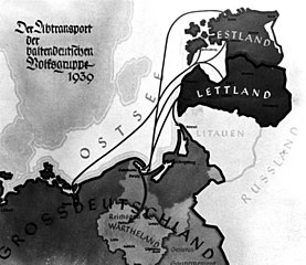
| Karte zur Umsiedlung Baltendeutscher
( |
|||||||||||||||||||||||||||
|---|---|---|---|---|---|---|---|---|---|---|---|---|---|---|---|---|---|---|---|---|---|---|---|---|---|---|---|
| Photographer |
Bogner |
||||||||||||||||||||||||||
| Title |
Karte zur Umsiedlung Baltendeutscher |
||||||||||||||||||||||||||
| Original caption |
For documentary purposes the German Federal Archive often retained the original image captions, which may be erroneous, biased, obsolete or politically extreme. Balten-Umsiedlung: Karte: Der Abtransport der baltendeutschen Volksgruppen
Die Linien auf diesem Kartenbild veranschaulichen den Weg der Rückwanderer aus dem Baltenland. Die meisten von ihnen haben im Wartheland ihre neue Heimat gefunden. Ein Teil von ihnen ist nunmehr im Gau Danzig-Westpreussen zu Hause. |
||||||||||||||||||||||||||
| Description |
English: Map showing the Nazi's plans for the forced relocation of Baltic Germans, called "remigrants", in "Warthegau" |
||||||||||||||||||||||||||
| Date | 1939 | ||||||||||||||||||||||||||
| Collection |
|
||||||||||||||||||||||||||
| Current location |
Deutsches Ausland-Institut (Bild 137) |
||||||||||||||||||||||||||
| Accession number | |||||||||||||||||||||||||||
| Source |
|
||||||||||||||||||||||||||


|
This old map image could be re-created using vector graphics as an SVG file. This has several advantages; see Commons:Media for cleanup for more information. If an SVG form of this image is available, please upload it and afterwards replace this template with
{{vector version available|new image name}}.
It is recommended to name the SVG file “Bundesarchiv Bild 137-066679, Karte zur Umsiedlung Baltendeutscher.svg”—then the template Vector version available (or Vva) does not need the new image name parameter. |


Licensing[edit]
This file is licensed under the Creative Commons Attribution-Share Alike 3.0 Germany license.
Attribution: Bundesarchiv, Bild 137-066679 / Bogner / CC-BY-SA 3.0
- You are free:
- to share – to copy, distribute and transmit the work
- to remix – to adapt the work
- Under the following conditions:
- attribution – You must give appropriate credit, provide a link to the license, and indicate if changes were made. You may do so in any reasonable manner, but not in any way that suggests the licensor endorses you or your use.
- share alike – If you remix, transform, or build upon the material, you must distribute your contributions under the same or compatible license as the original.

File history
Click on a date/time to view the file as it appeared at that time.
| Date/Time | Thumbnail | Dimensions | User | Comment | |
|---|---|---|---|---|---|
| current | 07:00, 14 April 2009 | | 800 × 693 (84 KB) | Cropbot (talk | contribs) | upload cropped version, operated by User:Yarnalgo. Summary: removed caption |
| 22:09, 3 December 2008 |  | 800 × 715 (86 KB) | BArchBot (talk | contribs) | == Summary == {{Information |Description={{de|1='''Karte zur Umsiedlung Baltendeutscher''' Balten-Umsiedlung: Karte: Der Abtransport der baltendeutschen Volksgruppen Die Linien auf diesem Kartenbild veranschaulichen den Weg der Rückwanderer aus dem Bal |
You cannot overwrite this file.
File usage on Commons
The following 2 pages use this file:
File usage on other wikis
The following other wikis use this file:
- Usage on ar.wikipedia.org
- Usage on de.wikipedia.org
- Usage on en.wikipedia.org
- Usage on eo.wikipedia.org
- Usage on et.wikipedia.org
- Usage on fi.wikipedia.org
- Usage on hu.wikipedia.org
- Usage on it.wikipedia.org
- Usage on ja.wikipedia.org
- Usage on lv.wikipedia.org
- Usage on nl.wikipedia.org
- Usage on no.wikipedia.org
- Usage on pl.wikipedia.org
- Usage on ru.wikipedia.org
- Usage on sv.wikipedia.org