File:Bulgaria geographic map Belasitsa Ograzhden bg.svg
Jump to navigation
Jump to search

Size of this PNG preview of this SVG file: 800 × 473 pixels. Other resolutions: 320 × 189 pixels | 640 × 378 pixels | 1,024 × 605 pixels | 1,280 × 757 pixels | 2,560 × 1,514 pixels | 4,228 × 2,500 pixels.
Original file (SVG file, nominally 4,228 × 2,500 pixels, file size: 10.06 MB)
Captions
Captions
Add a one-line explanation of what this file represents
Summary[edit]
| Description |
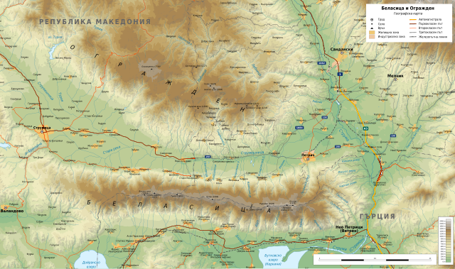
English: Geographic map of Belasitsa and Ograzhden, Bulgaria in Bulgarian. Geographic limits of the map:
Македонски: Топографска карта на Беласица и Огражден на бугарски јазик.
|
| Date | |
| Source |
Own work
|
| Author | Ikonact |
| Permission (Reusing this file) |
Any use of this map is subject of the license(s) stated below with the condition that you credit (Wikimedia Commons user: Ikonact) as the author . A message with a reply address would also be greatly appreciated. |
| Other versions | Macedonian version |

|
This SVG file contains embedded text that can be translated into your language, using any capable SVG editor, text editor or the SVG Translate tool. For more information see: About translating SVG files. |
Licensing[edit]
| This work contains information from OpenStreetMap, which is made available under the Open Database License (ODbL).
The ODbL does not require any particular license for maps produced from ODbL data. Prior to 1 August 2020, map tiles produced by the OpenStreetMap Foundation were licensed under the CC-BY-SA-2.0 license. Maps produced by other people may be subject to other licences. |
I, the copyright holder of this work, hereby publish it under the following license:
This file is licensed under the Creative Commons Attribution-Share Alike 4.0 International license.
- You are free:
- to share – to copy, distribute and transmit the work
- to remix – to adapt the work
- Under the following conditions:
- attribution – You must give appropriate credit, provide a link to the license, and indicate if changes were made. You may do so in any reasonable manner, but not in any way that suggests the licensor endorses you or your use.
- share alike – If you remix, transform, or build upon the material, you must distribute your contributions under the same or compatible license as the original.
File history
Click on a date/time to view the file as it appeared at that time.
| Date/Time | Thumbnail | Dimensions | User | Comment | |
|---|---|---|---|---|---|
| current | 21:35, 13 October 2018 | | 4,228 × 2,500 (10.06 MB) | Ikonact (talk | contribs) | + rivers, peaks, names |
| 21:07, 12 October 2018 |  | 4,228 × 2,500 (10.06 MB) | Ikonact (talk | contribs) | names | |
| 20:49, 12 October 2018 |  | 4,228 × 2,500 (10.05 MB) | Ikonact (talk | contribs) | +names, size optimisation | |
| 21:09, 11 October 2018 |  | 4,228 × 2,500 (15.61 MB) | Ikonact (talk | contribs) | text removed from corner | |
| 20:48, 11 October 2018 |  | 4,228 × 2,500 (15.56 MB) | Ikonact (talk | contribs) | == {{int:filedesc}} == {{Information |description={{en|1=Geographic map of Belasitsa and Ograzhden, Bulgaria in Bulgarian. Geographic limits of the map:}} {{bg|1=Географска карта на Беласица и Огражден. Карта на български. Граници на картата:}} *N: 41.65° N *S: 41.22° N *W: 22.55° E *E: 23.52° E Projection: Equidistant Cylindrical |date=2018-10-11 |source={{own}} *Sources of data:<br/> **Topograp... |
You cannot overwrite this file.
File usage on Commons
The following 2 pages use this file:
File usage on other wikis
The following other wikis use this file:
- Usage on bg.wikipedia.org
- Usage on en.wikipedia.org
- Usage on www.wikidata.org