File:Breimeier-Trassee.png
Jump to navigation
Jump to search

Size of this preview: 800 × 314 pixels. Other resolutions: 320 × 126 pixels | 640 × 251 pixels | 1,024 × 402 pixels | 1,280 × 503 pixels | 2,904 × 1,141 pixels.
Original file (2,904 × 1,141 pixels, file size: 4.54 MB, MIME type: image/png)
Captions
Captions
Add a one-line explanation of what this file represents
Summary[edit]
| Description |
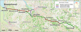
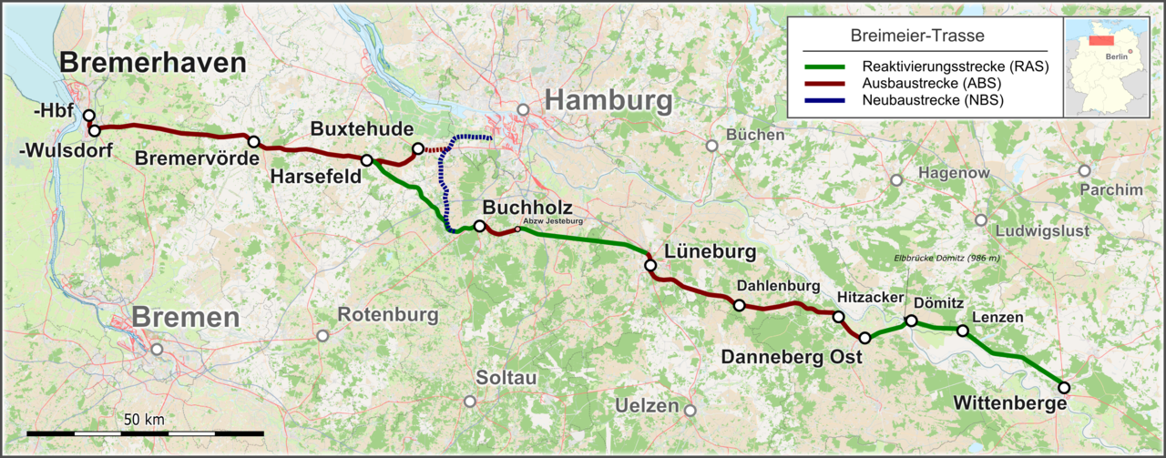
Deutsch: Verlauf der Breimeier-Trasse. Alternativvorschlag zur Y-Trasse, der die Knoten Bremen und Hamburg-Harburg entlastet. |
| Date | |
| Source |
Open Street Map Data Location map: Germany location map.svg Route data: Dr. Carsten Hein: Alternative Y-TrasseRudolf Breimeier: Alternativen zur Y-Trasse |
| Author |
Raw data map background: OpenStreetMap contributers, SRTM |
| Permission (Reusing this file) |
Map data (c) OpenStreetMap (and) contributors, CC-BY-SA |
Licensing[edit]
This file is licensed under the Creative Commons Attribution-Share Alike 4.0 International license.
- You are free:
- to share – to copy, distribute and transmit the work
- to remix – to adapt the work
- Under the following conditions:
- attribution – You must give appropriate credit, provide a link to the license, and indicate if changes were made. You may do so in any reasonable manner, but not in any way that suggests the licensor endorses you or your use.
- share alike – If you remix, transform, or build upon the material, you must distribute your contributions under the same or compatible license as the original.
| This work is licensed under the Open Database License (summary). |
File history
Click on a date/time to view the file as it appeared at that time.
| Date/Time | Thumbnail | Dimensions | User | Comment | |
|---|---|---|---|---|---|
| current | 23:43, 8 September 2015 | 2,904 × 1,141 (4.54 MB) | Pechristener (talk | contribs) | Typo-fix: 'Rotenburg', statt 'Rothenburg' | |
| 03:40, 8 May 2015 | 2,904 × 1,141 (4.54 MB) | Pechristener (talk | contribs) | Heine-Trassee ergänzt, Beschriftung neu arangiert | ||
| 03:37, 8 May 2015 | 2,904 × 1,141 (4.54 MB) | Pechristener (talk | contribs) | Heine-Trassee ergänzt, Beschriftung neu arangiert | ||
| 11:54, 6 April 2015 | 2,904 × 1,141 (4.53 MB) | Pechristener (talk | contribs) | zuvor falsche Datei hochgeladen | ||
| 10:30, 4 April 2015 | 3,095 × 1,216 (5.5 MB) | Pechristener (talk | contribs) | Dömitz korriegiert, Elbbrücke eingetragen | ||
| 18:38, 2 April 2015 | 2,904 × 1,141 (4.52 MB) | Pechristener (talk | contribs) | Distinction between upgraded, reactivated and new built routes. Caption and location map added | ||
| 15:51, 2 April 2015 | 2,904 × 1,141 (4.73 MB) | Pechristener (talk | contribs) | corr Dörnitz | ||
| 12:38, 2 April 2015 | 2,904 × 1,141 (4.73 MB) | Pechristener (talk | contribs) | background less intensive | ||
| 12:27, 2 April 2015 | 2,904 × 1,141 (4.96 MB) | Pechristener (talk | contribs) | neue Version generiert zusammen mit Kopiersperre | ||
| 12:23, 2 April 2015 | 2,904 × 1,141 (4.96 MB) | Pechristener (talk | contribs) | neue Version generiert zusammen mit kopiersperre |
You cannot overwrite this file.
File usage on Commons
The following 9 pages use this file:
- User:Chumwa/OgreBot/Public transport information/2015 April 1-10
- User:Chumwa/OgreBot/Public transport information/2015 May 1-10
- User:Chumwa/OgreBot/Public transport information/2015 September 1-10
- User:Chumwa/OgreBot/Transport Maps/2015 April 1-10
- User:Chumwa/OgreBot/Transport Maps/2015 May 1-10
- User:Chumwa/OgreBot/Transport Maps/2015 September 1-10
- User:Nordlicht8/Rail Germany/2015 April 1-10
- User:Nordlicht8/Rail Germany/2015 May 1-10
- User:Nordlicht8/Rail Germany/2015 September 1-10
File usage on other wikis
The following other wikis use this file:
- Usage on de.wikipedia.org