File:Boundary between Turkey and Armenia - as determined by Woodrow Wilson, president of the United States of America LOC 80695244.jpg
Jump to navigation
Jump to search

Size of this preview: 609 × 600 pixels. Other resolutions: 244 × 240 pixels | 487 × 480 pixels | 780 × 768 pixels | 1,039 × 1,024 pixels | 2,079 × 2,048 pixels | 8,953 × 8,820 pixels.
Original file (8,953 × 8,820 pixels, file size: 11.44 MB, MIME type: image/jpeg)
Captions
Captions
Add a one-line explanation of what this file represents
Summary
[edit]| Warning | The original file is very high-resolution. It might not load properly or could cause your browser to freeze when opened at full size. |
|---|
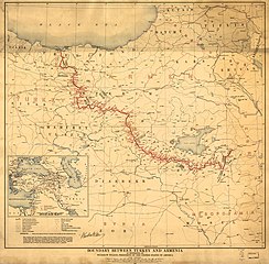
| Description |
English: Scale 1:1,000,000. Relief shown by spot heights. From the President Woodrow Wilson papers. Available also through the Library of Congress Web site as a raster image. Includes location map. LC copy 2 signed by Woodrow Wilson. Vault AACR2 |
||
| Title | Boundary between Turkey and Armenia : as determined by Woodrow Wilson, president of the United States of America | ||
| Shelf ID | G7431.F2 1920 .M3 | ||
| Date | |||
| Source | https://www.loc.gov/item/80695244/ | ||
| Author | Martin, Lawrence; Wilson, Woodrow; Geological Survey (U.S.). Topographic Branch; United States. Department Of State | ||
| Permission (Reusing this file) |
|
||
| Other versions |
|
||
| Location | Turkey · Armenia | ||
| Part of | American Memory · General Maps · Catalog · Geography And Map Division | ||
| Subject | Turkey · Boundaries · Armenia |


Licensing
[edit]
|
This is a faithful photographic reproduction of a two-dimensional, public domain work of art. The work of art itself is in the public domain for the following reason:
The official position taken by the Wikimedia Foundation is that "faithful reproductions of two-dimensional public domain works of art are public domain".
This photographic reproduction is therefore also considered to be in the public domain in the United States. In other jurisdictions, re-use of this content may be restricted; see Reuse of PD-Art photographs for details. | ||||
File history
Click on a date/time to view the file as it appeared at that time.
| Date/Time | Thumbnail | Dimensions | User | Comment | |
|---|---|---|---|---|---|
| current | 22:48, 23 May 2018 | | 8,953 × 8,820 (11.44 MB) | Fæ (talk | contribs) | LOC Maps https://www.loc.gov/item/80695244/ #257 |
You cannot overwrite this file.
File usage on Commons
The following 2 pages use this file:
File usage on other wikis
The following other wikis use this file:
- Usage on ru.wikipedia.org