File:Bathymetry and ocean currents of the Taiwan Strait and nearby areas.png
Jump to navigation
Jump to search

Size of this preview: 593 × 599 pixels. Other resolutions: 237 × 240 pixels | 475 × 480 pixels | 760 × 768 pixels | 1,205 × 1,218 pixels.
Original file (1,205 × 1,218 pixels, file size: 687 KB, MIME type: image/png)
Captions
Captions
Add a one-line explanation of what this file represents
Summary
[edit]
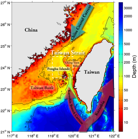
| Description |
English: Figure 1. Bathymetric chart (shaded color) and sketches of the China Coastal Current, Kuroshio, and Kuroshio Branch Current. |
| Date | |
| Source | Cheng, Y.-H.; Chang, M.-H. (2018). "Exceptionally cold water days in the southern Taiwan Strait: their predictability and relation to La Niña". Natural Hazards and Earth System Sciences Discussions 18 (7): 1999–2010. DOI:10.5194/nhess-18-1999-2018. |
| Author | Yu-Hsin Cheng, Ming-Huei Chang |
| Permission (Reusing this file) |
"All site content, except where otherwise noted, is licensed under the Creative Commons Attribution 4.0 License." |
Licensing
[edit]
This file is licensed under the Creative Commons Attribution-Share Alike 4.0 International license.
- You are free:
- to share – to copy, distribute and transmit the work
- to remix – to adapt the work
- Under the following conditions:
- attribution – You must give appropriate credit, provide a link to the license, and indicate if changes were made. You may do so in any reasonable manner, but not in any way that suggests the licensor endorses you or your use.
- share alike – If you remix, transform, or build upon the material, you must distribute your contributions under the same or compatible license as the original.
File history
Click on a date/time to view the file as it appeared at that time.
| Date/Time | Thumbnail | Dimensions | User | Comment | |
|---|---|---|---|---|---|
| current | 07:21, 10 May 2023 | | 1,205 × 1,218 (687 KB) | Tiouraren (talk | contribs) | Uploaded a work by Yu-Hsin Cheng, Ming-Huei Chang from {{cite journal|authors=Cheng, Y.-H.; Chang, M.-H.|year=2018|title=Exceptionally cold water days in the southern Taiwan Strait: their predictability and relation to La Niña|journal=Natural Hazards and Earth System Sciences Discussions|volume=18|issue=7|pages=1999–2010|doi=10.5194/nhess-18-1999-2018}} with UploadWizard |
You cannot overwrite this file.
File usage on Commons
There are no pages that use this file.
File usage on other wikis
The following other wikis use this file:
- Usage on en.wikipedia.org
- Usage on zh.wikipedia.org