File:Aubach Unterlauf Perchtoldsdorf Wien.jpg

Original file (3,612 × 2,084 pixels, file size: 5.51 MB, MIME type: image/jpeg)
Captions
Captions
Summary[edit]
| DescriptionAubach Unterlauf Perchtoldsdorf Wien.jpg |
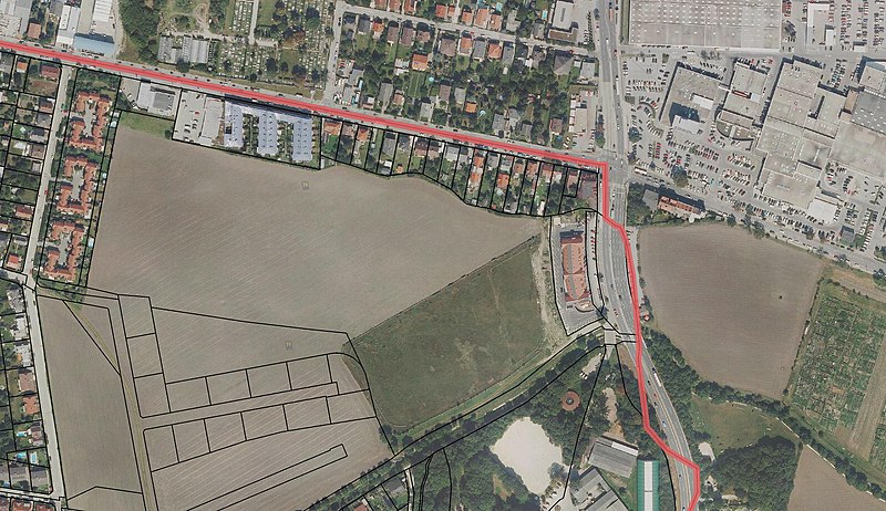
Deutsch: Grenze zwischen den Ländern Wien und Niederösterreich, Österreich, Grundstücksgrenzen des amtlichen Katasters. Der Verlauf von Grundstücksgrenzen,die in dem flachen Gebiet auf den ersten Blick nicht nachvollziehbare Linien ergeben, erklärt sich durch das Bachbett des früheren Wassergrabens, des Aubaches |
| Date | |
| Source | Geographisches Informationssystem des Landes Niederösterreich, Österreich. Grenzen und Grundstücke nach dem Kataster. Amtliche Werke, keine Werkhöhe, freies Werk |
| Author | Behörden des Landes Niederösterreich |
| Camera location | 48° 07′ 45.77″ N, 16° 17′ 44.09″ E | View this and other nearby images on: OpenStreetMap |
|---|
Licensing[edit]
| Public domainPublic domainfalsefalse |
This image is in the public domain according to Austrian copyright law because it is part of a law, ordinance or official decree issued by an Austrian federal or state authority, or because it is of predominantly official use. (§7 UrhG)
To uploader: Please provide where the image was first published and who created it. Deutsch ∙ English ∙ മലയാളം ∙ македонски ∙ русский ∙ Nederlands ∙ français ∙ magyar ∙ +/− |
| Annotations InfoField | This image is annotated: View the annotations at Commons |
Graben im Gelände
Die Südgrenze der Grundstücke zeichnet den ehemaligen Bachlauf nach
Der Aubach fließt hier nach Süden und mündet in den Petersbach
Grundstück des Petersbach-Laufes
Petersbach
Brücken über den Petersbach
Ketzergasse
Wien (23. Liesing)
Perchtoldsdorf
Brunnerstraße
Ketzergasse Richtung Siebenhirten und B 17
Theresienau
File history
Click on a date/time to view the file as it appeared at that time.
| Date/Time | Thumbnail | Dimensions | User | Comment | |
|---|---|---|---|---|---|
| current | 19:21, 15 January 2016 |  | 3,612 × 2,084 (5.51 MB) | Josef Moser (talk | contribs) | User created page with UploadWizard |
You cannot overwrite this file.
File usage on Commons
There are no pages that use this file.
Metadata
This file contains additional information such as Exif metadata which may have been added by the digital camera, scanner, or software program used to create or digitize it. If the file has been modified from its original state, some details such as the timestamp may not fully reflect those of the original file. The timestamp is only as accurate as the clock in the camera, and it may be completely wrong.
| Orientation | Normal |
|---|---|
| Horizontal resolution | 96 dpi |
| Vertical resolution | 96 dpi |
| Software used | Adobe Photoshop CS2 Windows |
| File change date and time | 20:11, 15 January 2016 |
| Color space | Uncalibrated |
| Image width | 3,612 px |
| Image height | 2,084 px |
| Date and time of digitizing | 21:11, 15 January 2016 |
| Date metadata was last modified | 21:11, 15 January 2016 |