File:Atlas of fifteen miles around Washington, including the counties of Fairfax and Alexandria, Virginia LOC map53000779.tif
Jump to navigation
Jump to search

Size of this JPG preview of this TIF file: 461 × 599 pixels. Other resolutions: 185 × 240 pixels | 369 × 480 pixels | 591 × 768 pixels | 788 × 1,024 pixels | 1,576 × 2,048 pixels | 3,980 × 5,170 pixels.
Original file (3,980 × 5,170 pixels, file size: 58.87 MB, MIME type: image/tiff)
Captions
Captions
Add a one-line explanation of what this file represents
Summary
[edit]| Description |
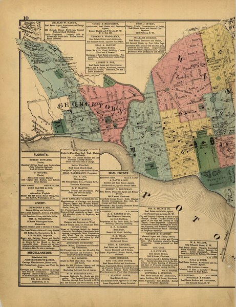
English: Some p. were originally folded. Phillips 1500 Available also through the Library of Congress Web site as a raster image. LC copy deacidified and rebound with each leaf encapsulated. Pages 86-87 numbered 76-77. Map of the United States on p. [90]-[91] and world map on p. [94]-[95]. |
||
| Title | Atlas of fifteen miles around Washington, including the counties of Fairfax and Alexandria, Virginia | ||
| Shelf ID | G1275 .H57 1879 | ||
| Date | |||
| Source | https://www.loc.gov/item/map53000779/ | ||
| Author | Hopkins, Griffith Morgan | ||
| Permission (Reusing this file) |
|
||
| Other versions |
|
||
| Location | Washington D.C. · Washington Suburban Area · Virginia · United States · District Of Columbia · Fairfax County | ||
| Part of | American Memory · Cities And Towns · Catalog · Geography And Map Division · Cultural Landscapes | ||
| Subject | Washington Suburban Area · Fairfax County (Va.) · Virginia · United States · Maps · District Of Columbia · Fairfax County · Real Property |


Licensing
[edit]|
This is a faithful photographic reproduction of a two-dimensional, public domain work of art. The work of art itself is in the public domain for the following reason:
The official position taken by the Wikimedia Foundation is that "faithful reproductions of two-dimensional public domain works of art are public domain".
This photographic reproduction is therefore also considered to be in the public domain in the United States. In other jurisdictions, re-use of this content may be restricted; see Reuse of PD-Art photographs for details. | ||||
File history
Click on a date/time to view the file as it appeared at that time.
| Date/Time | Thumbnail | Dimensions | User | Comment | |
|---|---|---|---|---|---|
| current | 06:02, 7 June 2018 |  | 3,980 × 5,170 (58.87 MB) | Fæ (talk | contribs) | LOC Maps https://www.loc.gov/item/map53000779/ #22453 |
You cannot overwrite this file.
File usage on Commons
The following page uses this file: