File:Atlas of Joan Martines WDL10091.pdf
Jump to navigation
Jump to search

Size of this JPG preview of this PDF file: 440 × 600 pixels. Other resolutions: 176 × 240 pixels | 352 × 480 pixels | 563 × 768 pixels | 751 × 1,024 pixels | 1,503 × 2,048 pixels | 2,752 × 3,750 pixels.

Original file (2,752 × 3,750 pixels, file size: 15.34 MB, MIME type: application/pdf, 19 pages)
Captions
Captions
Add a one-line explanation of what this file represents
Summary
[edit]| Author |
Русский: Мартинес, Хуан, 1556—1590 гг.
Français : Martines, Joan, 1556–1590
English: Martines, Joan, 1556–1590
中文:琼·马丁内斯,1556–1590 年
Português: Martines, Joan, 1556–1590
العربية: خوان مارتينيز، 1556–1590
Español: Martines, Joan, 1556–1590 |
| Title |
Русский: Атлас Хуана Мартинеса
Français : Atlas de Joan Martines
English: Atlas of Joan Martines
中文:琼·马丁内斯地图集
Português: Atlas de Joan Martines
العربية: أطلس خوان مارتينيز
Español: Atlas de Joan Martines |
| Description |
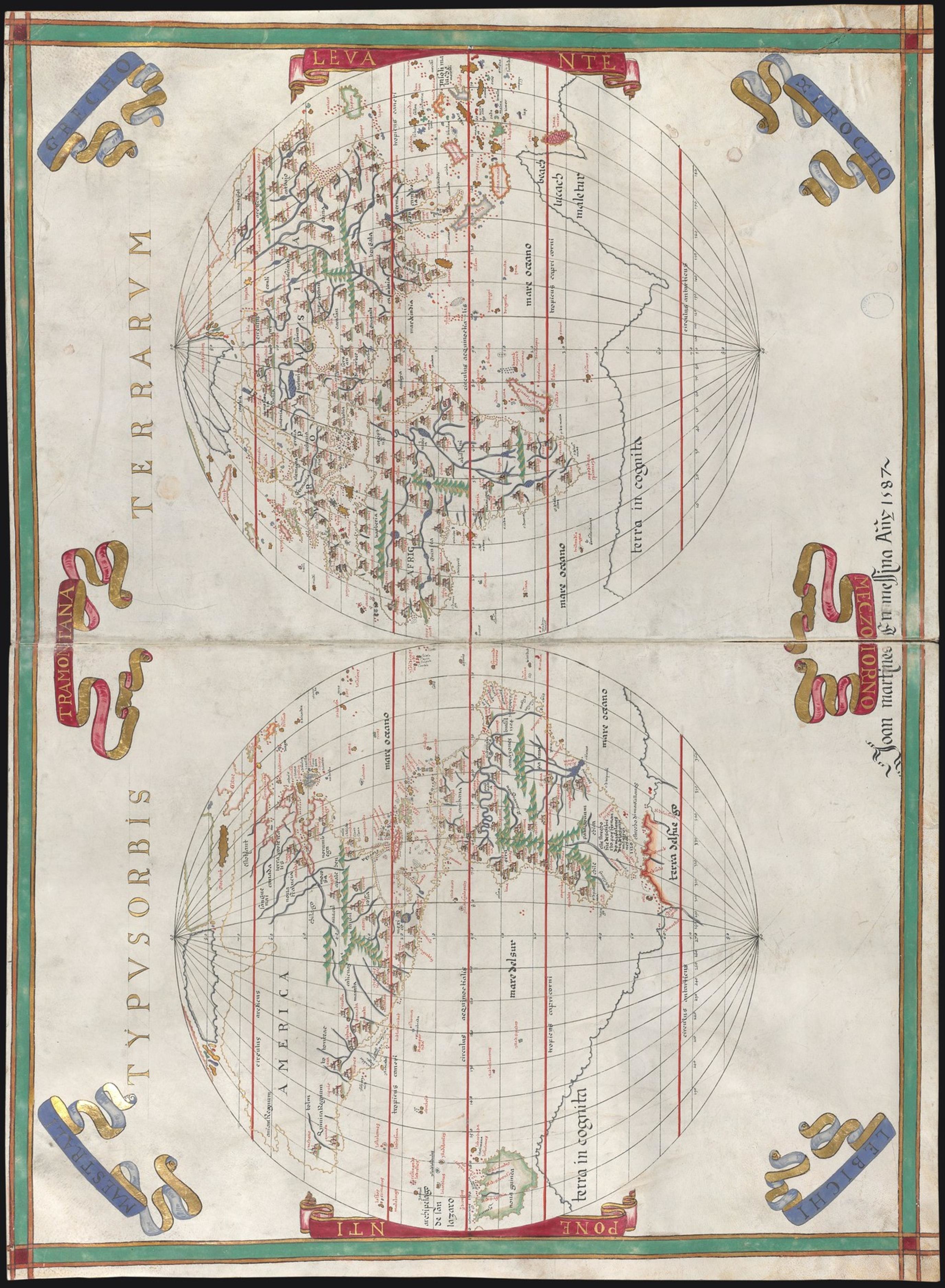
Русский: В этом рукописном атласе, созданном Хуаном Мартинесом, космографом короля Испании Филиппа II в 1587 г., представлено сочетание двух картографических школ, существовавших к моменту его создания. Более старая школа — традиционная школа Майорки — специализировалась на декоративных картах-портуланах, которые к тому моменту уже были устаревшими с точки зрения содержащейся в них географической информации. Более новая школа — картографическая школа Нидерландов — использовала принципы эпохи Возрождения и различные формы картографического представления, основанные на новых понятиях в астрономии, математике и географии; карты этой школы содержали больше информации, чем традиционные портуланы. Атлас состоит из 19 карт, каждая на двух страницах, с рисунками, занимающими практически всю длину страниц, обрамленными бордюрами разных цветов. Названия населенных пунктов написаны готическим шрифтом красными и черными чернилами, а также маленькими заглавными римскими буквами. В атлас входят шесть морских карт, 11 карт областей и две карты мира, пышно иллюминированные цветными рисунками с золотыми и серебряными панелями. На большинстве карт присутствует большая компасная роза, показывающая 16 или 32 направления, а на некоторых картах изображены корабли, плывущие по морям.
Иллюминирование рукописей; Рукописные карты; Морские карты; Карты-портуланы; Карты мира Français : Cet atlas manuscrit, daté de 1587 et réalisé par Joan Martines, cosmographe du roi Philippe II d'Espagne, constitue un mélange des deux écoles cartographiques existantes lors de sa création. La plus ancienne, l'école traditionnelle de Majorque, était spécialisée dans les cartes-portulans décoratives qui, à cette époque, transmettaient des informations géographiques obsolètes. La plus récente, l'école cartographique des Pays-Bas bourguignons, appliquait les principes de la Renaissance et utilisait différentes formes de représentation cartographique basées sur de nouveaux concepts d'astronomie, de mathématiques et de géographie afin de produire des cartes contenant davantage d'informations que les portulans traditionnels. Cet atlas comporte 19 cartes, chacune sur deux pages, avec des dessins occupant presque toute la longueur des pages et encadrés de bordures de différentes couleurs. Les noms de lieux sont écrits en lettres gothiques, à l'encre rouge et noire, et avec de petites majuscules en caractères romains. Il contient des cartes nautiques, 11 cartes régionales et deux mappemondes, chacune d'entre elles est somptueusement enluminée de dessins au lavis de couleurs, avec des panneaux dorés et argentés. La plupart des cartes sont accompagnées d'une rose des vents indiquant 16 ou 32 directions, et des bateaux naviguant sur les mers sont dessinés sur certaines.
Enluminures; Cartes manuscrites; Cartes marines; Cartes-portulans; Cartes du monde English: This manuscript atlas by Joan Martines, cosmographer to King Philip II of Spain, dated 1587, represents the combination of two cartographic schools that existed at the time of its creation. The older one was the traditional school of Majorca, which specialized in decorative portolan maps that by this time were obsolete with regard to the geographic information they conveyed. The newer one was the cartographic school of the Low Countries, which applied Renaissance principles and used different forms of cartographic representation based on new concepts in astronomy, mathematics, and geography to produce maps containing more information than the traditional portolans. The atlas consists of 19 maps, each on two pages, with the drawings occupying nearly the length of the pages and framed by edgings of different colors. Place-names are given in Gothic letters, in red and black ink, and in Roman small capitals. There are six nautical charts, 11 regional maps, and two maps of the world, all luxuriously illuminated in colored-wash drawing, with panes of gold and silver. Most of the maps have a large compass rose showing 16 or 32 directions, and some of the maps depict ships sailing the seas.
Illuminations; Manuscript maps; Nautical charts; Portolan charts; World maps 中文:这份手绘地图集由西班牙国王菲利普二世 (Philip II) 的宇宙学家琼·马丁内斯 (Joan Martines) 绘制于 1587 年,结合了当时的两个制图学派的风格。 旧的马略卡岛传统学派的波多兰航海图较注重装饰,但表达的地理信息不精确,在当时已经过时。 新的低地国家制图学派采用文艺复兴时期的原则,根据天文、数学和地理新概念,以不同的形式绘制地图,比传统的波多兰地图包含更多信息。 这份地图集包括 19 幅地图,每一幅占两个页面,图几乎铺满页面的整个长度,并以不同颜色的边框装饰。 地名用红色和黑色墨水以哥特式字体书写,采用小号的罗马大写字母。 图集中有 6 幅航海图、11 幅地区地图和两幅世界地图,所有地图均饰以华丽的水彩图以及金粉和银粉窗格。 大部分地图上均有一个大罗盘,显示 16 或 32 个方向,部分地图描绘了航行在海上的船舶。
插图; 手绘地图; 航海图; 波多兰航海图; 世界地图 Português: Este atlas manuscrito de Joan Martines, cosmógrafo do rei Filipe II da Espanha, com data de 1587, representa a combinação de duas escolas cartográficas que existiam no momento de sua criação. A mais antiga era a tradicional escola de Maiorca, que era especializada em mapas portolanos decorativos que, nessa época, eram obsoletos com relação às informações geográficas que transmitiam. A mais recente era a escola cartográfica dos Países Baixos, que aplicavam princípios da Renascença e usavam formas diferentes de representação cartográfica com base nos novos conceitos em astronomia, matemática e geografia para produzir mapas contendo mais informações que os portolanos tradicionais. O atlas consiste em 19 mapas, cada um em duas páginas, com os desenhos ocupando quase o comprimento das páginas e enquadrados por molduras de cores diferentes. Os nomes de locais são fornecidos em letras góticas, em vermelho e preto, e em letras maiúsculas romanas pequenas. Existem seis mapas náuticos, 11 mapas regionais e dois mapas do mundo, todos luxuosamente iluminados em desenhos pincelados coloridos, com áreas em ouro e prata. A maioria dos mapas tem uma rosa dos ventos grande que mostra 16 ou 32 direções, e alguns dos mapas relatam navios navegando nos mares.
Iluminuras; Mapas manuscritos; Cartas náuticas; Cartas portulanas; Mapas-múndi العربية: يرجع تاريخ هذا الأطلس المخطوط باليد والذي صممه الكوزوموغرافي خوان مارتينز لملك إسبانيا فيليب الثاني إلى عام 1587، ويُمثل اندماج مدرستين من مدارس رسم الخرائط كانتا قائمتين وقت تصميمه. كانت المدرسة الأقدم هي المدرسة التقليدية بمَيُورَقة، والتي تخصصت في تصميم خرائط البورتولان الزخرفية والتي كانت تُعد قديمة فيما يتعلق بالمعلومات التي تقدمها مقارنة بالوقت الذي ظهرت فيه. أما المدرسة الأخرى الأحدث فكانت مدرسة رسم الخرائط بالبلدان المنخفضة، والتي طبقت مبادئ عصر النهضة واستخدمت أشكالاً مختلفة من رسم الخرائط المبنية على مبادئ جديدة في علم الفلك والرياضيات والجغرافيا وذلك لتصميم خرائط تحتوي على معلومات أكثر من تلك الموجودة بخرائط البورتولان التقليدية. تضمن الأطلس 19 خريطة، كل منها من صفحتين، واحتلت الرسوم تقريباً كامل طول الصفحات وكانت مخيطة بإطارات بألوان مختلفة. أسماء الأماكن مكتوبة بحروف قوطية، بالحبر الأحمر والأسود وبحروف رومانية كبيرة بخط صغير. هناك ست خرائط ملاحية و11 خريطة إقليمية وخريطتان للعالم، وجميعها مزخرفة برسم مائي ملون بشكلٍ فخم، مع وجود بعض الأجزاء من الذهب والفضة. مُعظم الخرائط مزودة بمحور بوصلة كبير يُوضح 16 أو 32 اتجاهاً، وبعضها يرصد سفناً أثناء إبحارها.
الزخارف; الخرائط المخطوطة; الخرائط البحرية; الرسوم البيانية البورتولانية; خرائط العالم Español: Este atlas manuscrito de Joan Martines, cosmógrafo del rey Felipe II de España, fechado en 1587, representa la combinación de dos escuelas cartográficas que existían al momento de su creación. La más antigua era la escuela tradicional de Mallorca, especializada en mapas portuláneos decorativos que por esa época eran obsoletas con respecto a la información geográfica que transmitían. La más reciente era la escuela cartográfica de los Países Bajos, que aplicaba los principios del Renacimiento y utilizaba diferentes formas de representación cartográfica, sobre la base de nuevos conceptos en astronomía, matemática y geografía, para producir mapas que contenían más información que los portuláneos tradicionales. El atlas consta de 19 mapas, cada uno en dos páginas, con los dibujos que ocupan casi la longitud de las páginas y están enmarcados por ribetes de colores diferentes. Los topónimos están en letra gótica, en tinta roja y negra, y en pequeñas mayúsculas romanas. Hay seis cartas náuticas, 11 mapas regionales y dos mapas del mundo, todos lujosamente iluminados a la aguada, con áreas de oro y plata. La mayoría de los mapas tienen una gran rosa de los vientos que indica 16 o 32 direcciones, y algunos de los mapas muestran barcos que navegan los mares.
Iluminaciones; Mapas manuscritos; Cartas náuticas; Cartas portulanas; Mapas del mundo |
| Date | 1587 |
| Medium |
Русский: Карты
Français : Cartes
English: Maps
中文:地图
Português: Mapas
العربية: خرائط
Español: Mapas |
| Dimensions |
English: 19 maps ; 58 x 80 centimeters |
| Collection |
Русский: Национальная библиотека Испании
Français : Bibliothèque nationale d'Espagne
English: National Library of Spain
中文:西班牙国家图书馆
Português: Biblioteca Nacional da Espanha
العربية: مكتبة إسبانيا الوطنية
Español: Biblioteca Nacional de España |
| Place of creation |
Русский: Мир
Français : Monde
English: World
中文:世界
Português: Mundo
العربية: العالم
Español: Mundo |
| Notes | Original language title: Atlas de Joan Martines |
| References | http://hdl.loc.gov/loc.wdl/spmabn.10091 |
| Source/Photographer |
http://dl.wdl.org/10091/service/10091.pdf
|
Licensing
[edit]|
This is a faithful photographic reproduction of a two-dimensional, public domain work of art. The work of art itself is in the public domain for the following reason:
The official position taken by the Wikimedia Foundation is that "faithful reproductions of two-dimensional public domain works of art are public domain".
This photographic reproduction is therefore also considered to be in the public domain in the United States. In other jurisdictions, re-use of this content may be restricted; see Reuse of PD-Art photographs for details. | ||||
[Category:Portolan charts made in the 16th century]]
File history
Click on a date/time to view the file as it appeared at that time.
| Date/Time | Thumbnail | Dimensions | User | Comment | |
|---|---|---|---|---|---|
| current | 07:35, 12 July 2017 |  | 2,752 × 3,750, 19 pages (15.34 MB) | PawełMM (talk | contribs) | Reverted to version as of 11:01, 10 March 2014 (UTC) rotation not done! |
| 07:26, 12 July 2017 | No thumbnail | 0 × 0 (15.34 MB) | PawełMM (talk | contribs) | rotated | |
| 11:01, 10 March 2014 |  | 2,752 × 3,750, 19 pages (15.34 MB) | Fæ (talk | contribs) | =={{int:filedesc}}== {{Artwork |artist = |author ={{ru|1=Мартинес, Хуан, 1556—1590 гг.}} {{fr|1=Martines, Joan, 1556–1590}} {{en|1=Martines, Joan, 1556–1590}} {{zh|1=琼·马丁内斯,1556–1590 年}} {{pt|1=Martines, Joan, 1556... |
You cannot overwrite this file.
File usage on Commons
The following page uses this file: