File:AtlBalk1500.jpg
AtlBalk1500.jpg (318 × 327 pixels, file size: 162 KB, MIME type: image/jpeg)
Captions
Captions
Summary
[edit]
| Description |
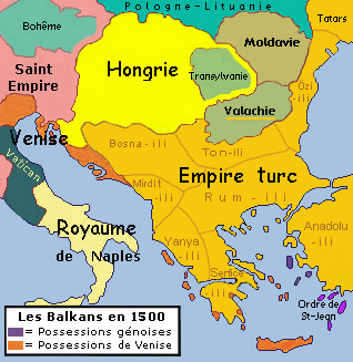
English: Historic map of Balkan peninsula, 1500
Français : Carte des Balkans en 1500 |
| Date | |
| Source | Own work |
| Author | Spiridon MANOLIU |
Cette carte, comme les 36 autres de cette série, est une synthèse du "Westermann Grosser Atlas zur Weltgeschichte", 1985, ISBN 3-14-100919-8, du "DTV Atlas zur Weltgeschichte", 1987 traduit chez Perrin, ISBN 2-7242-3596-7, du "Putzger historischer Weltatlas Cornelsen" 1990, ISBN 3-464-00176-8, de l'"Atlas historique Georges Duby" chez Larousse 1987, ISBN 2-03-503009-9, de la série des "Atlas des Peuples" d'André et Jean Sellier à La Découverte : "Europe occidentale" : 1995, ISBN 2-7071-2505-9, "Europe centrale" : 1992, ISBN 2-7071-2032-4, "Orient" : 1993, ISBN 2-7071-2222-X, avec des détails pris dans le Történelmi atlasz de l'Académie hongroise, 1991, ISBN 963-351-422-3 CM et dans l'Atlas istorico-geografic de l'Académie roumaine, 1995, ISBN 973-27-0500-0.
Licensing
[edit]

|
Permission is granted to copy, distribute and/or modify this document under the terms of the GNU Free Documentation License, Version 1.2 or any later version published by the Free Software Foundation; with no Invariant Sections, no Front-Cover Texts, and no Back-Cover Texts. A copy of the license is included in the section entitled GNU Free Documentation License. |
- You are free:
- to share – to copy, distribute and transmit the work
- to remix – to adapt the work
- Under the following conditions:
- attribution – You must give appropriate credit, provide a link to the license, and indicate if changes were made. You may do so in any reasonable manner, but not in any way that suggests the licensor endorses you or your use.
- share alike – If you remix, transform, or build upon the material, you must distribute your contributions under the same or compatible license as the original.
File history
Click on a date/time to view the file as it appeared at that time.
| Date/Time | Thumbnail | Dimensions | User | Comment | |
|---|---|---|---|---|---|
| current | 18:29, 20 February 2014 | | 318 × 327 (162 KB) | Spiridon Ion Cepleanu (talk | contribs) | Ottoman ilis (elis) since Berindei |
| 19:39, 1 March 2010 |  | 318 × 327 (151 KB) | Spiridon Ion Cepleanu (talk | contribs) | {{Information |Description={{en|1=Historic map of Balkan peninsula, 1500}} {{fr|1=Carte des Balkans en 1500}} |Source={{own}} |Author=Spiridon MANOLIU |Date=March 1, 2010 |Permission= |other_versions= }} Cette carte, comme les 36 |
You cannot overwrite this file.
File usage on Commons
The following page uses this file:
File usage on other wikis
The following other wikis use this file:
- Usage on fr.wikipedia.org
- Empire ottoman
- Histoire de la Roumanie
- Histoire de l'Albanie
- Histoire de la Bulgarie
- Histoire de la Croatie
- Histoire de la Hongrie
- Histoire de la Slovénie
- Histoire de la Serbie
- Histoire de la Macédoine du Nord
- Histoire de la Bosnie-Herzégovine
- Histoire du Monténégro
- Histoire de la Moldavie
- Guerres ottomanes en Europe
- Portail:Balkans
- Portail:Balkans/Histoire
- Histoire des Balkans
Metadata
- Maps of the Ottoman period in the history of the Balkans
- Maps of the history of the Ottoman Empire in the 1500s
- Maps of the history of Greece
- Maps of the history of Early Modern Romania
- Maps of the history of Transylvania
- Maps of the history of Moldova
- Maps of the history of Hungary in the Late Middle Ages
- Derivative maps of Putzgers Historischer Schul-Atlas